Navigation
PADI - ReActivate (Refresher)
Got a bit stale and been out of the water for a while, need to brush up on the basics skills again, this one is for you.
Cambridge
![]() Wreck Dive |
Wreck Dive | ![]() Boat access
Boat access
![]()
![]()
![]()
Steel Twin Screw Steamer | Max Depth: 68 m (223 ft)
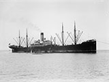
The Cambridge (SS Cambridge) was a refrigerated steam cargo liner that was built in Germany and launched in 1916 as the Vogtland. Later renamed Cambridge, she operated between Britain and Australasia until 1940, when a German mine sank her off the coast of Wilsons Promontory.
The shipwreck of the SS Cambridge is historically significant as the first Allied vessel to be lost in Australian waters in World War II. Along with the wrecks of the MS City of Rayville (1940), HMAS Goorangai (1940) and SS Iron Crown (1942) the Cambridge represents the arrival of World War II in Australian waters, the strategic importance of the Bass Strait shipping lane, and the extent of Axis activities in the Southern hemisphere.
Diving the Cambridge Shipwreck
The Cambridge was located on 21 May 1988 by the National Safety Council vessel M.V. Blue Nabila using side scan sonar. The vessel is relatively intact and lies in 68 metres of water. The GPS mark we have for the Cambridge is near the stern.
Cambridge Shipwreck History — Built in 1916
The Cambridge was a steel twin screw steamer built in 1916, by J. C. Tecklenborg AG in Wesermunde, Germany. She was built as a refrigerated steam cargo liner on a length of 524.5 ft (160 m), a breadth of 65.7 ft (20 m) and a draught of 37.3 ft (11 m). As built, her tonnages were Units: unknown unit type given, Units: unknown unit type given and Units: unknown unit type given. Her holds had Units: unknown unit type given of refrigerated cargo space.
The vessel had two screws, each driven by a triple expansion engine. Between them her twin engines were rated at 1,106 nominal horsepower (nhp) or 3,475 indicated horsepower (ihp), giving her a speed of 14 knots (26 kpm). The ship had one funnel and four masts.
The steamer was originally built as the Vogtland, but after World War 1, the vessel was taken as part war reparations and its name changed to Cambridge.
Cambridge Sinking — Wrecked 7 November 1940
While on a voyage from Cardiff (United Kingdom) to Brisbane via Sydney, with tin plate and a general cargo, with a crew of 58 under the command of Captain A. J. Paddy Agnell, the SS Cambridge struck a German mine and sunk in Bass Strait, 3.7 nm (6.85 km) SE of Wilsons Promontory.
At about 11 p.m. on Thursday 7 November 1940 as the Cambridge headed east past Wilsons Promontory, a sudden explosion occurred and the vessel started to sink by the stern. The explosion occurred in the after end of the ship. An attempt to send out a distress signal on the wireless failed because the dynamos had been damaged in the explosion. The emergency wireless set was used to send distress signals. As the ship was settling quickly the crew were mustered and ordered to abandon ship, and three lifeboats were launched.
The lifeboats with the crew aboard quickly cleared the sinking vessel. However, the ship's carpenter, J. Kinnear, was observed on the deck of the Cambridge. Because of the danger of being submerged by the suction of the fast sinking vessel, the lifeboats were unable to get close enough to save him. It was believed that he went below to retrieve personal items when the rest of the crew were abandoning ship.
Captain Angell later described the Cambridge as it "sank under the waves and disappeared leaving only a great spout of water and steam rising into the sky, then settling down into a bubbling patch of sea".
The gear from the lifeboats was salved but the boats themselves were abandoned because the sea was too rough to take them in tow. The crew then spent an anxious night floating around in a minefield. They knew land was not far away as they could see the South-East Point lighthouse, but were additionally worried about drifting further out to sea. However they were picked up in the morning by the minesweeper HMAS Orara, and taken ashore at Port Welshpool.
Bass Strait was closed to shipping and the HMAS Orara and another minesweeper the HMAS Durraween commenced sweeping off the Promontory on 9 November 1940, and eventually 43 mines from the Bass Strait fields were detonated or rendered safe after being washed ashore.
See also, Wikipedia: SS Cambridge (1916),
Heritage Council Victoria: SS Cambridge, and
Australian National Shipwreck Database: S.S.Cambridge.
Heritage Warning: Any shipwreck or shipwreck relic that is 75 years or older is protected by legislation. Other items of maritime heritage 75 years or older are also protected by legislation. Activities such as digging for bottles, coins or other artefacts that involve the disturbance of archaeological sites may be in breach of the legislation, and penalties may apply. The legislation requires the mandatory reporting to Heritage Victoria as soon as practicable of any archaeological site that is identified. See Maritime heritage. Anyone with information about looting or stolen artefacts should call Heritage Victoria on (03) 7022 6390, or send an email to heritage.victoria@delwp.vic.gov.au.
Bass Strait Warning: Always keep an eye on sea conditions throughout any shore or boat dive in Bass Strait on Victoria's coastline. Please read the warnings on the web page diving-in-bass-strait before diving or snorkelling this site.
Finding the Cambridge Shipwreck
Over the years we've been provided with different GPS marks for the Cambridge shipwreck. The GPS marks we know of in circulation for the Cambridge are:
- GetUnder Dive Club (verified):
Latitude: 39° 9.660′ S (39.161° S / 39° 9′ 39.6″ S)
Longitude: 146° 29.748′ E (146.4958° E / 146° 29′ 44.88″ E)
- GPS:
Latitude: 39° 9.810′ S (39.1635° S / 39° 9′ 48.6″ S)
Longitude: 146° 29.780′ E (146.496333° E / 146° 29′ 46.8″ E)
282 m, bearing 170°, S
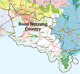
Traditional Owners — This dive site is in the traditional Country of the Boon Wurrung / Bunurong people of the Kulin Nation. This truly ancient Country includes parts of Port Phillip, from the Werribee River in the north-west, down to Wilson's Promontory in the south-east, including the Mornington Peninsula, French Island and Phillip Island, plus Western Port. We wish to acknowledge the Boon Wurrung as Traditional Owners. We pay respect to their Ancestors and their Elders, past, present and emerging. We acknowledge Bunjil the Creator Spirit of this beautiful land, who travels as an eagle, and Waarn, who protects the waterways and travels as a crow, and thank them for continuing to watch over this Country today and beyond.
Cambridge Location Map
Latitude: 39° 9.660′ S (39.161° S / 39° 9′ 39.6″ S)
Longitude: 146° 29.748′ E (146.4958° E / 146° 29′ 44.88″ E)
Datum: WGS84 |
Google Map
Added: 2012-07-22 09:00:00 GMT, Last updated: 2022-04-27 08:27:30 GMT
Source: GetUnder Dive Club (verified) - near the stern
Nearest Neighbour: South East Point, 6,921 m, bearing 298°, WNW
Steel twin screw steamer.
Built: Wesermunde, Germany, 1916.
Sunk:7 November 1940.
Wilsons Promontory, Bass Strait.
Depth: 68 m.
Dive only on:SWF, SWE.
[ Top ]
DISCLAIMER: No claim is made by The Scuba Doctor as to the accuracy of the dive site coordinates listed here. Should anyone decide to use these GPS marks to locate and dive on a site, they do so entirely at their own risk. Always verify against other sources.
The marks come from numerous sources including commercial operators, independent dive clubs, reference works, and active divers. Some are known to be accurate, while others may not be. Some GPS marks may even have come from maps using the AGD66 datum, and thus may need be converted to the WGS84 datum. To distinguish between the possible accuracy of the dive site marks, we've tried to give each mark a source of GPS, Google Earth, or unknown.




![Halcyon Infinity 30lb System [SS Small Backplate] Halcyon Infinity 30lb System [SS Small Backplate]](/diveshop/images/halcyon/Halcyon-Evolve-Wing.jpg)


