Navigation
Shark Repellent Systems
These shark defence products repel the sharks via an electric field that induces spasms in the sharks' snouts. It does not attract sharks to the area or leave permanent damage to the animals, or harm the environment. These products are proven to prevent shark attacks.
Rubicon
![]() Wreck Dive |
Wreck Dive | ![]() Boat access
Boat access
![]()
![]()
![]()
![]()
Two-Masted Topsail Wooden Schooner | Max Depth: 4 m (13 ft)
Level: Open Water and beyond.
The schooner Rubicon was loading lime for Melbourne at the jetty at Walkerville when a heavy swell set in. The vessel was hauled off from the jetty to the safety of the anchorage. Shortly afterwards, the wind shifted and the ship parted from its cables and drove onto the rocks to become a total wreck in Waratah Bay, Wilson Promontory.
Rubicon Shipwreck History
The Rubicon was a two-masted topsail schooner of 64 l-ton (65 t), built in 1872, by Sydney Griffiths, Port Sorell in Tasmania. The vessel has a square stern with dimensons of 74.9 ft (23 m) long, breath of 19.64 ft (5.99 m)1, and a depth of 8.6 ft (2.62 m).
In August 1882, the Rubicon was purchased by William Froggatt Walker, who had interests in the lime kilns at Waratah Bay. These kilns supplied Melbourne, and to a lesser extent Sydney and the Gippsland Lakes with building line. The Rubicon was thus employed in transporting the products of these kilns to various destinations around the coast.
Rubicon Sinking
On the evening of 10 October 1887, the Rubicon, under the command of Captain Henry John Cameron with a crew of seven, had loaded 700 bags of lime. The weather was deteriorating with the wind from the south-west, but at midnight the wind backed around to the south-east and freshened to hurricane force.
The hurricane caused the Rubicon to be plunged for a few seconds in the mountainous sea. She then parted both or anchors, carried away the buoy, and in less than 5 minutes was on the reef. The captain had only time to fire a gun and burn a signal of distress to alert those on shore. The sound of the gun above the roaring of the sea reached the ears of Mr Wallace, state school teacher, and in a moment he, along with Mr Dewar and a band of gallant fellows, were climbing in the darkness onto the face of the rugged cliffs to render what assistance they could to the ill-fated crew, whose position at the time was too awful to contemplate. The ship lay broadside on the reef, the seas making a clean sweep right over her.
One of the crew endeavoured to swim ashore, but became tangled in the reef and was thought to be lost. The remainder of the crew abandoned the stricken schooner in the ship's boat, only to be immediately swamped. After much exertion the lifeboat was got onto the davits again and subsequently emptied of water. The crew then re-entered the boat to pull for the shore and safety.
Luckily for the crew member previously stranded in the water, his cries for help were heard and he was pulled aboard, only to be flung onto the rocks in the lifeboat with his shipmates. The lifeboat was totally destroyed, but the crew with some help from a party on shore, were all landed safely. The Rubicon was very quickly destroyed on the rocks, with little of any worth being salvaged from the wreck.
The Victorian Steam Navigation Board investigated the circumstances attending the wrecking of the Rubicon and found that the wreck was caused by stress of weather and no claim could be attached to master or crew.
See also, Heritage Council Victoria: Rubicon, and
Australian National Shipwreck Database: Rubicon.
Heritage Warning: Any shipwreck or shipwreck relic that is 75 years or older is protected by legislation. Other items of maritime heritage 75 years or older are also protected by legislation. Activities such as digging for bottles, coins or other artefacts that involve the disturbance of archaeological sites may be in breach of the legislation, and penalties may apply. The legislation requires the mandatory reporting to Heritage Victoria as soon as practicable of any archaeological site that is identified. See Maritime heritage. Anyone with information about looting or stolen artefacts should call Heritage Victoria on (03) 7022 6390, or send an email to heritage.victoria@delwp.vic.gov.au.
Bass Strait Warning: Always keep an eye on sea conditions throughout any shore or boat dive in Bass Strait on Victoria's coastline. Please read the warnings on the web page diving-in-bass-strait before diving or snorkelling this site.
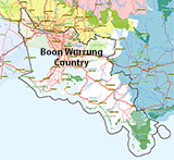
Traditional Owners — This dive site is in the traditional Country of the Boon Wurrung / Bunurong people of the Kulin Nation. This truly ancient Country includes parts of Port Phillip, from the Werribee River in the north-west, down to Wilson's Promontory in the south-east, including the Mornington Peninsula, French Island and Phillip Island, plus Western Port. We wish to acknowledge the Boon Wurrung as Traditional Owners. We pay respect to their Ancestors and their Elders, past, present and emerging. We acknowledge Bunjil the Creator Spirit of this beautiful land, who travels as an eagle, and Waarn, who protects the waterways and travels as a crow, and thank them for continuing to watch over this Country today and beyond.
Rubicon Location Map
Latitude: 38° 51.500′ S (38.858333° S / 38° 51′ 30″ S)
Longitude: 146° 36.390′ E (146.6065° E / 146° 36′ 23.4″ E)
Datum: WGS84 |
Google Map
Added: 2012-07-22 09:00:00 GMT, Last updated: 2022-04-26 18:44:42 GMT
Source: GPS
Nearest Neighbour: Rabbit Island, North, 9,837 m, bearing 235°, SW
Two-Masted Topsail Wooden Schooner.
Built: 1972.
Sunk: 10 October 1887.
Bass Strait.
Depth: 4 m.
[ Top ]
DISCLAIMER: No claim is made by The Scuba Doctor as to the accuracy of the dive site coordinates listed here. Should anyone decide to use these GPS marks to locate and dive on a site, they do so entirely at their own risk. Always verify against other sources.
The marks come from numerous sources including commercial operators, independent dive clubs, reference works, and active divers. Some are known to be accurate, while others may not be. Some GPS marks may even have come from maps using the AGD66 datum, and thus may need be converted to the WGS84 datum. To distinguish between the possible accuracy of the dive site marks, we've tried to give each mark a source of GPS, Google Earth, or unknown.


![Halcyon Infinity 30lb System [SS Small Backplate] Halcyon Infinity 30lb System [SS Small Backplate]](/diveshop/images/halcyon/Halcyon-Evolve-Wing.jpg)


