Navigation
Every freediver knows how important the little things are to make your dive go smoothly. Here at The Scuba Doctor dive shop you will find the Freediving Accessories and Spares you need to have a successful outing.
Black Rock Jetty, Half Moon Bay
![]() Pier Dive |
Pier Dive | ![]() Shore access
Shore access
![]()
![]()
![]()
![]()
Depth: 2 m (6.56 ft) to 8 m (26 ft)
Level: Open Water and beyond.
Ideal Conditions:
Best dived when the wind blows from the north-west, but good in anything but a southerly. Avoid during a southerly as the area can get quite choppy. Just before the high tide will give the clearest water. See WillyWeather (Black Rock) as a guide for the tide times and the height of the tide.
What To Expect:
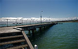
Black Rock Jetty in Half Moon Bay, Port Phillip, is a good site for new divers. Around the Black Rock Jetty are small leather jackets, starfish, gobbleguts and the occasional seahorse. The underwater terrain varies from jetty pylons to rocky reefs to seagrass beds. You'll have all kinds of company, including sea urchins, anemones, nudibranchs and (poisonous) blue-ringed octopuses.
Half Moon Bay, home to the Black Rock Yacht Club and the Half Moon Bay Lifesaving Club, is the crescent-shaped small sandy shallow area to the left of the car park. It is an excellent night dive especially in spring when the phosphorescence is at its brightest. At night you can find octopus, flathead and bull rays.
First proceed from the shore under the jetty out to the end. Then take a heading west and cross the sand plains in a depth of about 5 to 6 metres. You'll find the bottom of a reef in a depth of 3 metres. Follow the reef around the point. Exit up the western beach.
Parking:
You can usually park in the car park, but it fills quickly on nice days. Parking is metered so get a ticket.
Dive Entry:
Enter the water down at the ramp and dive out under the pier. Always take a dive flag!
Also worth a note is the historic protected shipwreck of the HMVS Cerberus warship. Divers are banned from the 0.5-hectare rectangle protective zone around the wreck. It's also too dangerous, so please keep a distance away. The guns from the warship lie on the sandy bottom nearby.
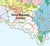
Traditional Owners — This dive site is in the traditional Country of the Boon Wurrung / Bunurong people of the Kulin Nation. This truly ancient Country includes parts of Port Phillip, from the Werribee River in the north-west, down to Wilson's Promontory in the south-east, including the Mornington Peninsula, French Island and Phillip Island, plus Western Port. We wish to acknowledge the Boon Wurrung as Traditional Owners. We pay respect to their Ancestors and their Elders, past, present and emerging. We acknowledge Bunjil the Creator Spirit of this beautiful land, who travels as an eagle, and Waarn, who protects the waterways and travels as a crow, and thank them for continuing to watch over this Country today and beyond.
Black Rock Jetty, Half Moon Bay Location Map
Latitude: 37° 58.158′ S (37.969295° S / 37° 58′ 9.46″ S)
Longitude: 145° 0.590′ E (145.009838° E / 145° 0′ 35.42″ E)
Datum: WGS84 |
Google Map
| Get directions
Added: 2012-07-22 09:00:00 GMT, Last updated: 2022-03-22 15:04:23 GMT
Source: Google Earth
Nearest Neighbour: Cerberus, 274 m, bearing 321°, NW
Black Rock, Bayside, Port Phillip.
Depth: 2 to 8 m.
[ Top ]
DISCLAIMER: No claim is made by The Scuba Doctor as to the accuracy of the dive site coordinates listed here. Should anyone decide to use these GPS marks to locate and dive on a site, they do so entirely at their own risk. Always verify against other sources.
The marks come from numerous sources including commercial operators, independent dive clubs, reference works, and active divers. Some are known to be accurate, while others may not be. Some GPS marks may even have come from maps using the AGD66 datum, and thus may need be converted to the WGS84 datum. To distinguish between the possible accuracy of the dive site marks, we've tried to give each mark a source of GPS, Google Earth, or unknown.
Copyright © 2005-2022 by The Scuba Doctor Australia, ABN 88 116 755 170. All rights reserved.
tel. +61 3 5985 1700 :: email. diveshop@scubadoctor.com.au :: Web site by it'sTechnical 2022









![Halcyon Infinity 30lb System [SS Small Backplate] Halcyon Infinity 30lb System [SS Small Backplate]](/diveshop/images/halcyon/Halcyon-Evolve-Wing.jpg)


