Recent Dive Sites

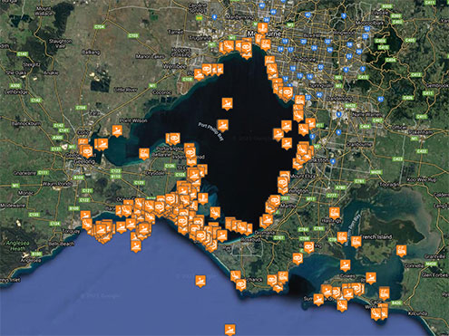
Here are the latest ten dive sites added to our list of Melbourne and Victorian dive sites.
The Passage Reef Deep | Reef Dive | Boat access |
| Latitude: 38° 24.509′ S (38.408483° S / 38° 24′ 30.54″ S) Longitude: 141° 38.703′ E (141.645053° E / 141° 38′ 42.19″ E) | ||
| Datum: WGS84 | Google Map | |
| Added: 2022-05-24 05:33:28 GMT, Last updated: 2022-05-24 05:36:36 GMT Source: GPS | ||
| Nearest Neighbour: Big Reef, Portland , 556 m, bearing 38°, NE | ||
| Portland, Discovery Coast. Depth: 15 to 20 m. | ||
| See the The Passage Reef Deep dive site page | ||
The Passage Reef Shallow | Reef Dive | Boat access |
| Latitude: 38° 23.870′ S (38.397837° S / 38° 23′ 52.21″ S) Longitude: 141° 39.250′ E (141.654166° E / 141° 39′ 15″ E) | ||
| Datum: WGS84 | Google Map | |
| Added: 2022-05-24 05:21:05 GMT, Last updated: 2022-05-24 05:36:36 GMT Source: GPS | ||
| Nearest Neighbour: Little Reef, Portland , 514 m, bearing 58°, ENE | ||
| Portland, Discovery Coast. Depth: 10 to 15 m. | ||
| See the The Passage Reef Shallow dive site page | ||
Grant Bay Reef | Reef Dive | Boat access |
| Latitude: 38° 23.776′ S (38.396267° S / 38° 23′ 46.56″ S) Longitude: 141° 38.072′ E (141.63454° E / 141° 38′ 4.34″ E) | ||
| Datum: WGS84 | Google Map | |
| Added: 2022-05-23 06:13:07 GMT, Last updated: 2022-05-23 23:33:51 GMT Source: GPS | ||
| Nearest Neighbour: Grant Bay Beach, 750 m, bearing 286°, WNW | ||
| Grant Bay, Portland, Discovery Coast. Depth: 5 to 12 m. | ||
| See the Grant Bay Reef dive site page | ||
Boat Bay | Reef Dive | Shore access |
| Latitude: 38° 34.860′ S (38.580996° S / 38° 34′ 51.59″ S) Longitude: 142° 49.688′ E (142.828125° E / 142° 49′ 41.25″ E) | ||
| Datum: WGS84 | Google Map | Get directions | |
| Added: 2022-05-21 22:38:38 GMT, Last updated: 2022-05-23 11:40:52 GMT Source: Goggle Earth | ||
| Nearest Neighbour: Bay of Islands, 577 m, bearing 253°, WSW | ||
| Peterborough, Shipwreck Coast. Depth: 2 to 20 m. | ||
| See the Boat Bay dive site page | ||
Hopkins Reef | Reef Dive | Boat access |
| Latitude: 38° 24.474′ S (38.407903° S / 38° 24′ 28.45″ S) Longitude: 142° 30.419′ E (142.506986° E / 142° 30′ 25.15″ E) | ||
| Datum: WGS84 | Google Map | |
| Added: 2022-05-21 09:48:42 GMT, Last updated: 2022-05-23 11:20:12 GMT Source: Google Earth | ||
| Nearest Neighbour: Edinburgh Castle, 1,239 m, bearing 321°, NW | ||
| Warrnambool, Shipwreck Coast. Depth: 6 to 12 m. | ||
| See the Hopkins Reef dive site page | ||
Horseshoe Reef | Reef Dive | Boat access |
| Latitude: 38° 22.712′ S (38.37853° S / 38° 22′ 42.71″ S) Longitude: 141° 24.718′ E (141.411963° E / 141° 24′ 43.07″ E) | ||
| Datum: WGS84 | Google Map | |
| Added: 2022-05-20 20:07:06 GMT, Last updated: 2022-05-23 08:12:34 GMT Source: Google Earth | ||
| Nearest Neighbour: SS Barwon, 163 m, bearing 352°, N | ||
| Cape Bridgewater, Portland, Discovery Coast. Depth: 2 to 8 m. | ||
| See the Horseshoe Reef dive site page | ||
Yellow Rock Beach | Reef Dive | Shore access |
| Latitude: 38° 23.289′ S (38.388155° S / 38° 23′ 17.36″ S) Longitude: 141° 34.918′ E (141.581961° E / 141° 34′ 55.06″ E) | ||
| Datum: WGS84 | Google Map | Get directions | |
| Added: 2022-05-20 12:24:41 GMT, Last updated: 2022-05-23 08:19:22 GMT Source: Google Earth | ||
| Nearest Neighbour: Flat Rock, Cape Nelson, 1,371 m, bearing 223°, SW | ||
| Nelson Bay, Portland, Discovery Coast. Depth: 5 to 10 m. | ||
| See the Yellow Rock Beach dive site page | ||
Seal Colony, Cape Bridgewater | Reef Dive | Boat access |
| Latitude: 38° 23.540′ S (38.392334° S / 38° 23′ 32.4″ S) Longitude: 141° 24.806′ E (141.41343° E / 141° 24′ 48.35″ E) | ||
| Datum: WGS84 | Google Map | |
| Added: 2022-05-20 08:14:07 GMT, Last updated: 2022-05-23 08:12:57 GMT Source: Google Earth | ||
| Nearest Neighbour: Horseshoe Reef, 1,540 m, bearing 355°, N | ||
| Cape Bridgewater, Portland, Discovery Coast. Depth: 5 to 10 m. | ||
| See the Seal Colony, Cape Bridgewater dive site page | ||
The Boatshed, Cape Bridgewater | Reef Dive | Boat access |
| Latitude: 38° 22.616′ S (38.37694° S / 38° 22′ 36.98″ S) Longitude: 141° 24.446′ E (141.407433° E / 141° 24′ 26.76″ E) | ||
| Datum: WGS84 | Google Map | |
| Added: 2022-05-20 07:08:18 GMT, Last updated: 2022-05-23 08:14:03 GMT Source: GPS | ||
| Nearest Neighbour: SS Barwon, 375 m, bearing 92°, E | ||
| Cape Bridgewater, Portland, Discovery Coast. Depth: 2 to 8 m. | ||
| See the The Boatshed, Cape Bridgewater dive site page | ||
Brads Bommie | Bommie Dive | Boat access |
| Latitude: 38° 23.612′ S (38.393541° S / 38° 23′ 36.75″ S) Longitude: 141° 38.778′ E (141.646299° E / 141° 38′ 46.68″ E) | ||
| Datum: WGS84 | Google Map | |
| Added: 2022-05-20 06:22:40 GMT, Last updated: 2022-05-24 05:36:34 GMT Source: Google Earth | ||
| Nearest Neighbour: The Passage Reef Shallow, 836 m, bearing 124°, SE | ||
| Point Danger, Portland, Discovery Coast. Depth: 5 to 15 m. | ||
| See the Brads Bommie dive site page | ||
Total of 10 dive sites.
[ Top ]
DISCLAIMER: No claim is made by The Scuba Doctor as to the accuracy of the dive site coordinates listed here. Should anyone decide to use these GPS marks to locate and dive on a site, they do so entirely at their own risk. Always verify against other sources.
The marks come from numerous sources including commercial operators, independent dive clubs, reference works, and active divers. Some are known to be accurate, while others may not be. Some GPS marks may even have come from maps using the AGD66 datum, and thus may need be converted to the WGS84 datum. To distinguish between the possible accuracy of the dive site marks, we've tried to give each mark a source, e.g. GPS, Google Earth, or unknown.
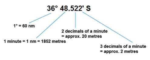
If you don't understand the differences between the different ways coordinates are given, plus how different datum come into play, you might find the article GPS Conversions by Lloyd Borrett a useful read. It describes the problems associated with locating dive sites using a GPS receiver.

Scuba Doctor Dive Map KML File
In the true spirit of making it easy to obtain, utilise and share the information for non-commercial purposes, you can now Download/view the Scuba Doctor Dive Map GPS Marks (KML file | 427.19 KB | 24-May-2022) in the Keyhole Markup Language (KML) file format used to display geographic data in an Earth browser such as Google Earth or Google Maps.
Some marine GPS units can import the information from a KML file. For others you can use use a file translate program (e.g. GPSBabel) to convert the KML file into an import file format (e.g. GPX) supported by your GPS unit.
Please Help Us To Correct GPS Marks and Add More Melbourne Dive Sites
If you have have information about other dive sites you'd be happy to see added to the information available here, or any corrections and/or updates to the diving site GPS marks listed here, please feel free to Contact Us. See also, Dive Site Help.

