Melbourne Pier Dives

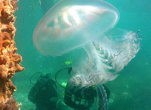
Divers with Jellyfish at Blairgowrie Pier, Anzac Day 2006. Photo: David Bryant, SeaPics.
Given the greater city of Melbourne and surrounds includes the shorelines of Port Phillip (shore length 264 km) and Western Port (shore length 263 km), there are many piers, jetties, wharfs and quays which are great dive sites. We have customers who almost exclusively dive Blairgowrie Pier, with occasional visits to Rosebud Pier or Flinders Pier. So much diversity and great stuff to see and it's just an easy pier dive away.
Underwater footage illustrating the beautiful marine life found in the southern waters
of Port Phillip in Melbourne, Australia. | David Bryant, SeaPics.
10 Things You May Not Know About Diving Victoria's Piers
- Spoiled For Choice
Victoria is loaded with easily accessible pier diving choices, attracting divers from interstate and overseas, plus many die-hard local divers. From Flinders Pier in Western Port to nearby Mordialloc, Mornington, Rye, Blairgowrie, Sorrento and Portsea Piers on the Mornington Peninsula and across to St Leonards Pier near Queenscliff, this smorgasbord of options rates with some of the best dives in the country and rarely disappoint. - The Ultimate Artificial Reefs
Piers in Victoria generally feature long rows of wooden pylons coupled with expansive wooden or concrete seawalls. These structures become encrusted with vibrant sponges, ascidians, bryzoans and kelp, forming a rich tapestry that plays host to all manner of sea life. Some piers rival the Great Barrier Reef for colour and diversity, often in just two to six metres depth. - Teeming With Life In Critter Paradise
Dragons and ponies. Smooth rays, eagle rays, skates and banjo sharks. Giant cuttlefish, squid squads and octopus allsorts. Angel and Port Jackson sharks. Tasseled anglerfish, sea jellies and seals. Leatherjackets, salmon, pipefish, dragonets, blennies, seamoths, goblinfish and gobies. Massive seasonal aggregations of giant spider crabs, nudibranchs galore and more. Even the odd cormorant, penguin or lost turtle have been spotted beneath Victoria's piers. - Each Pier Has A Unique Personality
Flinders Pier is renowned for weedy sea dragons and draughtboard sharks. Sorrento Pier can only be dived at night after the ferry to Queenscliff has stopped operating. Blairgowrie Pier is considered a Mecca for nudibranchs, offers some of the greatest diversity of marine life in the state and — being well protected — is diveable under most conditions. - And Each Is Best Dived Under Certain Conditions
While Victoria's piers can generally be dived any time of the day or night and all year round, each has its own optimal conditions based on wind direction and strength, and time of entry in relation to the tide (visibility is often better on incoming and around high tide). Willyweather and webcams are a pier diver's best buddy in pre-assessing likely conditions beneath the surface. - Intricate Tapestries Of Micro-Environments
Don't under-estimate less obvious parts of the terrain. Be sure to thoroughly explore the sandy bottom, surrounding seagrass, pylons, seawalls, natural and man-made nooks and crannies and the surrounding open water (though make sure you watch out for hooks and lines in action from the pier above!) - The Slower You Go, The More You Will See
While it might be tempting to think of the pier as some sort of end-to-end underwater racetrack, the slower you go, the more you will see. - Buoyancy Is Key
Careless diving can quickly silt up the water, and fins swiping against sandy bottoms and pylons can cause significant damage to marine life. Neutral buoyancy will always result in a better experience for you and for the environment you are visiting. - Piers Are Subject To Construction, Decay And Repairs
Piers are subject to works in alignment with human needs and responsibilities. The current replacement of the eastern seawall at Blairgowrie Pier provides excellent opportunities for volunteer divers to be involved in the ground breaking 'Operation Sponge'. This initiative aims to salvage thousands of sponges, relocating them to new sections of seawall before the decaying sections are removed from the water (well worth checking out on Facebook and getting involved!) - Pier Diving Is 100% Addictive
Victoria's piers are accessible for divers of all levels and experience and filled with endless possibilities for underwater photographers. Satisfy you OCD (Obsessive Compulsive Diving) and check out one of Victoria's amazing piers soon!
The above information is taken, with permission, from an article by PT Hirschfield (Pink Tank Scuba), as published in the September 2016 edition of DiveLog Australasia on page 16. See also PT's blog, Pink Tank Scuba.
[ Top ]
Best 5 Melbourne Pier Dive Sites
Our five favourite Melbourne pier dive sites, listed in order of popularity, are:
Blairgowrie Pier | Pier Dive | Shore access |
| Latitude: 38° 21.407′ S (38.356778° S / 38° 21′ 24.4″ S) Longitude: 144° 46.416′ E (144.773597° E / 144° 46′ 24.95″ E) | ||
| Datum: WGS84 | Google Map | Get directions | |
| Added: 2012-07-22 01:00:00 GMT, Last updated: 2022-04-14 04:30:20 GMT Source: Google Earth | ||
| Nearest Neighbour: Geoffs Scallop Hole, 2,001 m, bearing 97°, E | ||
| Blairgowrie, Mornington Peninsula, Port Phillip. Depth: 2 to 7 m. | ||
| See the Blairgowrie Pier dive site page | ||
Rye Pier | Pier Dive | Shore access |
| Latitude: 38° 21.968′ S (38.366125° S / 38° 21′ 58.05″ S) Longitude: 144° 49.378′ E (144.822961° E / 144° 49′ 22.66″ E) | ||
| Datum: WGS84 | Google Map | Get directions | |
| Added: 2012-07-22 01:00:00 GMT, Last updated: 2022-04-15 06:29:26 GMT Source: Google Earth | ||
| Nearest Neighbour: Eivion, 114 m, bearing 154°, SSE | ||
| Rye, Mornington Peninsula, Port Phillip. Depth: 1 to 6 m. | ||
| See the Rye Pier dive site page | ||
Flinders Pier | Pier Dive | Shore access |
| Latitude: 38° 28.534′ S (38.475562° S / 38° 28′ 32.02″ S) Longitude: 145° 1.624′ E (145.027069° E / 145° 1′ 37.45″ E) | ||
| Datum: WGS84 | Google Map | Get directions | |
| Added: 2012-07-22 01:00:00 GMT, Last updated: 2022-05-22 23:47:55 GMT Source: Google Earth | ||
| Nearest Neighbour: Mushroom Reef, 1,137 m, bearing 233°, SW | ||
| Flinders, Mornington Peninsula, Western Port. Depth: 1 to 6 m. | ||
| See the Flinders Pier dive site page | ||
Portsea Pier | Pier Dive | Shore access |
| Latitude: 38° 19.107′ S (38.318444° S / 38° 19′ 6.4″ S) Longitude: 144° 42.803′ E (144.713389° E / 144° 42′ 48.2″ E) | ||
| Datum: WGS84 | Google Map | Get directions | |
| Added: 2012-07-22 01:00:00 GMT, Last updated: 2022-04-15 06:10:19 GMT Source: Google Earth | ||
| Nearest Neighbour: Portsea Cray Reef, 178 m, bearing 45°, NE | ||
| Portsea, Mornington Peninsula, Port Phillip. Depth: 1 to 7 m. | ||
| See the Portsea Pier dive site page | ||
Mornington Pier | Pier Dive | Shore access |
| Latitude: 38° 12.761′ S (38.212684° S / 38° 12′ 45.66″ S) Longitude: 145° 2.016′ E (145.033593° E / 145° 2′ 0.93″ E) | ||
| Datum: WGS84 | Google Map | Get directions | |
| Added: 2012-07-22 01:00:00 GMT, Last updated: 2022-04-15 06:04:39 GMT Source: Google Earth | ||
| Nearest Neighbour: Schnapper Point, Mornington Pier, 96 m, bearing 263°, W | ||
| Mornington, Mornington Peninsula, Port Phillip. Depth: 1 to 12 m. | ||
| See the Mornington Pier dive site page | ||
Most of the above details about our favourite pier dives were kindly provided by Michael Mallis.
[ Top ]
Other Melbourne Pier, Jetty, Wharf and Quay Dive Sites
Altona Pier | Pier Dive | Shore access |
| Latitude: 37° 52.384′ S (37.873071° S / 37° 52′ 23.06″ S) Longitude: 144° 49.812′ E (144.830199° E / 144° 49′ 48.72″ E) | ||
| Datum: WGS84 | Google Map | Get directions | |
| Added: 2012-07-22 01:00:00 GMT, Last updated: 2021-07-25 06:36:10 GMT Source: Google Earth | ||
| Nearest Neighbour: Seaholme Reef, Altona, 1,447 m, bearing 67°, ENE | ||
| Altona, Hobson's Bay, Port Phillip. Depth: 1 to 5 m. | ||
| See the Altona Pier dive site page | ||
Black Rock Jetty, Half Moon Bay | Pier Dive | Shore access |
| Latitude: 37° 58.158′ S (37.969295° S / 37° 58′ 9.46″ S) Longitude: 145° 0.590′ E (145.009838° E / 145° 0′ 35.42″ E) | ||
| Datum: WGS84 | Google Map | Get directions | |
| Added: 2012-07-22 01:00:00 GMT, Last updated: 2022-03-22 05:04:23 GMT Source: Google Earth | ||
| Nearest Neighbour: Cerberus, 274 m, bearing 321°, NW | ||
| Black Rock, Bayside, Port Phillip. Depth: 2 to 8 m. | ||
| See the Black Rock Jetty, Half Moon Bay dive site page | ||
No locations found. |
Clifton Springs Piers | Shore Dive | Shore access |
| Latitude: 38° 9.177′ S (38.15295° S / 38° 9′ 10.62″ S) Longitude: 144° 33.726′ E (144.5621° E / 144° 33′ 43.56″ E) | ||
| Datum: WGS84 | Google Map | Get directions | |
| Added: 2012-07-22 01:00:00 GMT, Last updated: 2022-03-22 04:13:16 GMT Source: Google Earth | ||
| Nearest Neighbour: Clifton Springs, Steamship Pier, 599 m, bearing 48°, NE | ||
| Bellarine Peninsula. Depth: 1 to 4 m. | ||
| See the Clifton Springs Piers dive site page | ||
Cunningham Pier, Geelong | Pier Dive | Shore access |
| Latitude: 38° 8.534′ S (38.142239° S / 38° 8′ 32.06″ S) Longitude: 144° 21.725′ E (144.362077° E / 144° 21′ 43.48″ E) | ||
| Datum: WGS84 | Google Map | Get directions | |
| Added: 2012-07-22 01:00:00 GMT, Last updated: 2022-03-22 04:21:53 GMT Source: Google Earth | ||
| Nearest Neighbour: Lightning, 266 m, bearing 96°, E | ||
| Geelong, Corio Bay. Depth: 3 to 10 m. | ||
| See the Cunningham Pier, Geelong dive site page | ||
Dromana Pier | Pier Dive | Shore access |
| Latitude: 38° 19.914′ S (38.331906° S / 38° 19′ 54.86″ S) Longitude: 144° 57.890′ E (144.964837° E / 144° 57′ 53.41″ E) | ||
| Datum: WGS84 | Google Map | Get directions | |
| Added: 2012-07-22 01:00:00 GMT, Last updated: 2022-04-14 09:07:32 GMT Source: Google Earth | ||
| Nearest Neighbour: Cicada, 1,177 m, bearing 51°, NE | ||
| Dromana, Mornington Peninsula, Port Phillip. Depth: 1 to 5 m. | ||
| See the Dromana Pier dive site page | ||
Frankston Pier | Pier Dive | Shore access |
| Latitude: 38° 8.730′ S (38.145497° S / 38° 8′ 43.79″ S) Longitude: 145° 6.778′ E (145.112969° E / 145° 6′ 46.69″ E) | ||
| Datum: WGS84 | Google Map | Get directions | |
| Added: 2012-07-22 01:00:00 GMT, Last updated: 2022-03-22 05:14:22 GMT Source: Google Earth | ||
| Nearest Neighbour: Frankston Reef, Olivers Hill, 1,330 m, bearing 211°, SSW | ||
| Frankston, Mornington Peninsula, Port Phillip. Depth: 3 to 6 m. | ||
| See the Frankston Pier dive site page | ||
Gem Pier | Pier Dive | Shore access |
| Latitude: 37° 51.683′ S (37.861378° S / 37° 51′ 40.96″ S) Longitude: 144° 54.337′ E (144.905623° E / 144° 54′ 20.24″ E) | ||
| Datum: WGS84 | Google Map | Get directions | |
| Added: 2012-07-22 01:00:00 GMT, Last updated: 2022-03-22 04:45:16 GMT Source: Google Earth | ||
| Nearest Neighbour: Point Gellibrand, 1,113 m, bearing 182°, S | ||
| Williamstown, Port Phillip. Depth: 1 to 5 m. | ||
| See the Gem Pier dive site page | ||
Hastings Pier | Pier Dive | Shore access |
| Latitude: 38° 18.491′ S (38.308187° S / 38° 18′ 29.47″ S) Longitude: 145° 11.944′ E (145.199073° E / 145° 11′ 56.66″ E) | ||
| Datum: WGS84 | Google Map | Get directions | |
| Added: 2012-07-22 01:00:00 GMT, Last updated: 2022-03-22 06:10:50 GMT Source: Google Earth | ||
| Nearest Neighbour: Red Bird, 268 m, bearing 99°, E | ||
| Hastings, Mornington Peninsula, Western Port. Depth: 3 to 5 m. | ||
| See the Hastings Pier dive site page | ||
Kerferd Road Pier | Pier Dive | Shore access |
| Latitude: 37° 50.985′ S (37.849746° S / 37° 50′ 59.09″ S) Longitude: 144° 57.045′ E (144.950752° E / 144° 57′ 2.71″ E) | ||
| Datum: WGS84 | Google Map | Get directions | |
| Added: 2012-07-22 01:00:00 GMT, Last updated: 2022-03-27 08:32:12 GMT Source: Google Earth | ||
| Nearest Neighbour: Lagoon Pier, 1,069 m, bearing 300°, WNW | ||
| Albert Park, Bayside, Port Phillip. Depth: 2 to 5 m. | ||
| See the Kerferd Road Pier dive site page | ||
Lagoon Pier | Pier Dive | Shore access |
| Latitude: 37° 50.694′ S (37.844908° S / 37° 50′ 41.67″ S) Longitude: 144° 56.414′ E (144.940234° E / 144° 56′ 24.84″ E) | ||
| Datum: WGS84 | Google Map | Get directions | |
| Added: 2021-07-17 15:52:30 GMT, Last updated: 2022-03-27 08:41:44 GMT Source: Google Earth | ||
| Nearest Neighbour: Kerferd Road Pier, 1,069 m, bearing 120°, ESE | ||
| Port Melbourne, Bayside, Port Phillip. Depth: 1 to 4 m. | ||
| See the Lagoon Pier dive site page | ||
Mordialloc Pier | Pier Dive | Shore access |
| Latitude: 38° 0.742′ S (38.01236° S / 38° 0′ 44.5″ S) Longitude: 145° 5.004′ E (145.083405° E / 145° 5′ 0.26″ E) | ||
| Datum: WGS84 | Google Map | Get directions | |
| Added: 2012-07-22 01:00:00 GMT, Last updated: 2022-03-22 05:11:08 GMT Source: Google Earth | ||
| Nearest Neighbour: Aspendale Rec Reef, 2,704 m, bearing 192°, SSW | ||
| Mordialloc, Bayside, Port Phillip. Depth: 2 to 6 m. | ||
| See the Mordialloc Pier dive site page | ||
Point Lonsdale Jetty | Pier Dive | Shore access |
| Latitude: 38° 17.498′ S (38.291637° S / 38° 17′ 29.89″ S) Longitude: 144° 36.970′ E (144.616169° E / 144° 36′ 58.21″ E) | ||
| Datum: WGS84 | Google Map | Get directions | |
| Added: 2012-07-22 01:00:00 GMT, Last updated: 2022-04-06 11:35:21 GMT Source: Google Earth | ||
| Nearest Neighbour: Point Lonsdale Light, 38 m, bearing 241°, WSW | ||
| Port Phillip Heads Marine National Park. Point Lonsdale, Bellarine Peninsula. Depth: 3 to 5 m. | ||
| See the Point Lonsdale Jetty dive site page | ||
Portarlington Pier | Pier Dive | Shore access |
| Latitude: 38° 6.752′ S (38.112541° S / 38° 6′ 45.15″ S) Longitude: 144° 39.109′ E (144.651819° E / 144° 39′ 6.55″ E) | ||
| Datum: WGS84 | Google Map | Get directions | |
| Added: 2012-07-22 01:00:00 GMT, Last updated: 2022-03-22 04:08:30 GMT Source: GPS | ||
| Nearest Neighbour: Steeles Rocks, Portarlington, 1,175 m, bearing 87°, E | ||
| Bellarine Peninsula. Depth: 2 to 5 m. | ||
| See the Portarlington Pier dive site page | ||
Rippleside Jetty, Geelong | Pier Dive | Shore access |
| Latitude: 38° 7.719′ S (38.128648° S / 38° 7′ 43.13″ S) Longitude: 144° 21.438′ E (144.357307° E / 144° 21′ 26.31″ E) | ||
| Datum: WGS84 | Google Map | Get directions | |
| Added: 2021-07-18 08:07:42 GMT, Last updated: 2022-03-22 04:22:43 GMT Source: Google Earth | ||
| Nearest Neighbour: Rippleside Pier, Geelong, 233 m, bearing 15°, NNE | ||
| Geelong, Corio Bay. Depth: 1 to 5 m. | ||
| See the Rippleside Jetty, Geelong dive site page | ||
Rippleside Pier, Geelong | Pier Dive | Shore access |
| Latitude: 38° 7.598′ S (38.126633° S / 38° 7′ 35.88″ S) Longitude: 144° 21.482′ E (144.358035° E / 144° 21′ 28.93″ E) | ||
| Datum: WGS84 | Google Map | Get directions | |
| Added: 2012-07-22 01:00:00 GMT, Last updated: 2022-03-22 04:23:43 GMT Source: Google Earth | ||
| Nearest Neighbour: Rippleside Jetty, Geelong, 233 m, bearing 195°, SSW | ||
| Geelong, Corio Bay. Depth: 1 to 5 m. | ||
| See the Rippleside Pier, Geelong dive site page | ||
Sorrento Pier | Pier Dive | Shore access |
| Latitude: 38° 20.141′ S (38.335677° S / 38° 20′ 8.44″ S) Longitude: 144° 44.753′ E (144.745887° E / 144° 44′ 45.19″ E) | ||
| Datum: WGS84 | Google Map | Get directions | |
| Added: 2012-07-22 01:00:00 GMT, Last updated: 2022-04-15 06:24:03 GMT Source: Google Earth | ||
| Nearest Neighbour: Sorrento Boat Moorings, 262 m, bearing 323°, NW | ||
| Sorrento, Mornington Peninsula, Port Phillip. Depth: 1 to 7 m. | ||
| See the Sorrento Pier dive site page | ||
St Kilda Pier | Pier Dive | Shore access |
| Latitude: 37° 51.871′ S (37.864512° S / 37° 51′ 52.24″ S) Longitude: 144° 58.122′ E (144.968698° E / 144° 58′ 7.31″ E) | ||
| Datum: WGS84 | Google Map | Get directions | |
| Added: 2012-07-22 01:00:00 GMT, Last updated: 2022-03-22 04:51:35 GMT Source: Google Earth | ||
| Nearest Neighbour: Point Ormond Reef, 2,168 m, bearing 161°, SSE | ||
| St Kilda, Bayside, Port Phillip. Depth: 4 to 8 m. | ||
| See the St Kilda Pier dive site page | ||
St Leonards Pier | Pier Dive | Shore access |
| Latitude: 38° 10.213′ S (38.170223° S / 38° 10′ 12.8″ S) Longitude: 144° 43.246′ E (144.720771° E / 144° 43′ 14.78″ E) | ||
| Datum: WGS84 | Google Map | Get directions | |
| Added: 2012-07-22 01:00:00 GMT, Last updated: 2022-04-18 06:23:19 GMT Source: Google Earth | ||
| Nearest Neighbour: Governor Reef, 1,873 m, bearing 18°, NNE | ||
| St Leonards, Bellarine Peninsula. Depth: 4 to 6 m. | ||
| See the St Leonards Pier dive site page | ||
[ Top ]
Spearfishing is illegal within 30 metres of any pier or jetty and in Marine National Parks. See Spearfishing Laws.
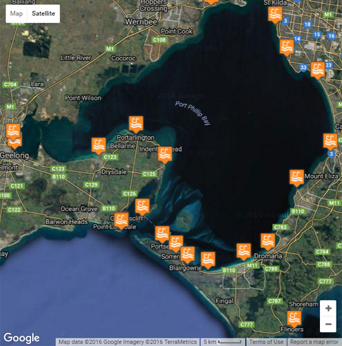
For more information about the great pier dives available in Melbourne, please see our Melbourne Shore Dives and Melbourne Dive Sites Map pages.
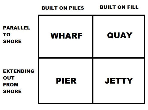
Pier, Jetty, Wharf or Quay?
If you don't know the difference between a pier, jetty, wharf or quay, then this simple diagram should help you to understand.

DISCLAIMER: No claim is made by The Scuba Doctor as to the accuracy of the dive site coordinates listed here. Should anyone decide to use these GPS marks to locate and dive on a site, they do so entirely at their own risk. Always verify against other sources.
The marks come from numerous sources including commercial operators, independent dive clubs, reference works, and active divers. Some are known to be accurate, while others may not be. Some GPS marks may even have come from maps using the AGD66 datum, and thus may need be converted to the WGS84 datum. To distinguish between the possible accuracy of the dive site marks, we've tried to give each mark a source, e.g. GPS, Google Earth, or unknown.
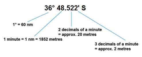
If you don't understand the differences between the different ways coordinates are given, plus how different datum come into play, you might find the article GPS Conversions by Lloyd Borrett a useful read. It describes the problems associated with locating dive sites using a GPS receiver.

Scuba Doctor Dive Map KML File
In the true spirit of making it easy to obtain, utilise and share the information for non-commercial purposes, you can now Download/view the Scuba Doctor Dive Map GPS Marks (KML file | 427.19 KB | 24-May-2022) in the Keyhole Markup Language (KML) file format used to display geographic data in an Earth browser such as Google Earth or Google Maps.
Some marine GPS units can import the information from a KML file. For others you can use use a file translate program (e.g. GPSBabel) to convert the KML file into an import file format (e.g. GPX) supported by your GPS unit.
Please Help Us To Correct GPS Marks and Add More Melbourne Dive Sites
If you have have information about other dive sites you'd be happy to see added to the information available here, or any corrections and/or updates to the diving site GPS marks listed here, please feel free to Contact Us. See also, Dive Site Help.


