J Class Submarine Wreck Dives

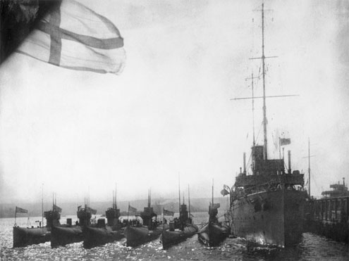
Six J-class subs next to their supply ship HMAS Platypus in 1919
When they were built in 1915–1917 for the Royal Navy, the seven J Class Submarines were the fastest in the world with a surface speed of 19 kn (35 kpm) and a submerged speed of 9.4 kn (17 kpm). Between them in World War I, the submarines sank a German U-boat, and heavily damaged two battleships. The HMS J6 Submarine was sunk in error in 1918 from 'friendly' fire by a British ship.
The remaining six submarines were gifted from the British government to the Royal Australian Navy in March 1919. They arrived in Sydney on 15 July 1919 and were extensively refitted at the Garden Island Dockyard. They then served from their submarine base in Geelong, Victoria.
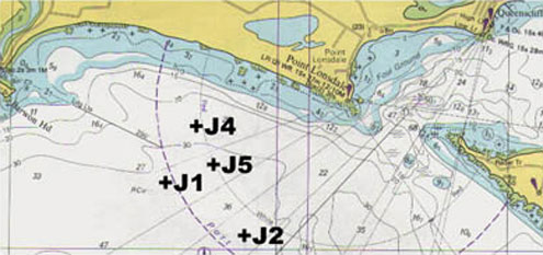
In 1924 the J1, J2, J4 and J5 submarines were sold to a salvage company which stripped them of valuable materials. They were then scuttled in 1926 outside of The Port Phillip Heads in the Victorian Ships' Graveyard, Bass Strait. They are an exciting and awe inspiring playground for divers.
The J3 was sunk at Swan Island for use as both a jetty, and a power source for the military base. The J7 was sunk as a breakwater at the Sandringham Yacht Club.

Chart location of J class submarines
J1 Deep Submarine | Wreck Dive | Boat access |
| Latitude: 38° 18.959′ S (38.315988° S / 38° 18′ 57.56″ S) Longitude: 144° 33.219′ E (144.553648° E / 144° 33′ 13.13″ E) | ||
| Datum: WGS84 | Google Map | |
| Added: 2012-07-22 01:00:00 GMT, Last updated: 2022-04-28 07:49:27 GMT Source: Book - Victoria's Ships' Graveyard GPS (verified) | ||
| Nearest Neighbour: New Deep Bommie, 1,157 m, bearing 101°, E | ||
| J-Class Submarine, 1820 ton. Built: Portsmouth, UK, 1915/1916. Scuttled: 26 May 1926. Victorian Ships' Graveyard, Bass Strait. Depth: 31 to 38 m. | ||
| See the J1 Deep Submarine dive site page | ||
J2 Broken Submarine | Wreck Dive | Boat access |
| Latitude: 38° 18.814′ S (38.31357° S / 38° 18′ 48.85″ S) Longitude: 144° 34.803′ E (144.580048° E / 144° 34′ 48.17″ E) | ||
| Datum: WGS84 | Google Map | |
| Added: 2012-07-22 01:00:00 GMT, Last updated: 2022-04-28 07:49:55 GMT Source: Book - Victoria's Ships' Graveyard GPS (verified) | ||
| Nearest Neighbour: Lost Reef, 430 m, bearing 154°, SSE | ||
| J-Class Submarine, 1820 ton. Built: Portsmouth, UK, 1915/1916. Scuttled: 1 June 1926. Victorian Ships' Graveyard, Bass Strait. Depth: 31 to 39 m. | ||
| See the J2 Broken Submarine dive site page | ||
J3 Swan Island Submarine | Wreck Dive | Boat access |
| Latitude: 38° 14.643′ S (38.24405° S / 38° 14′ 38.58″ S) Longitude: 144° 42.183′ E (144.70305° E / 144° 42′ 10.98″ E) | ||
| Datum: WGS84 | Google Map | |
| Added: 2012-07-22 01:00:00 GMT, Last updated: 2022-03-27 07:52:01 GMT Source: GPS | ||
| Nearest Neighbour: S.F. Hersey, 178 m, bearing 216°, SW | ||
| J-Class Submarine, 1820 ton. Built: Dyfed, Wales, 1916. Scuttled: January 1926. Bellarine Peninsula, Port Phillip. Depth: 0 to 8 m. | ||
| See the J3 Swan Island Submarine dive site page | ||
J4 26m Submarine | Wreck Dive | Boat access |
| Latitude: 38° 17.979′ S (38.299657° S / 38° 17′ 58.77″ S) Longitude: 144° 33.820′ E (144.563673° E / 144° 33′ 49.22″ E) | ||
| Datum: WGS84 | Google Map | |
| Added: 2012-07-22 01:00:00 GMT, Last updated: 2022-05-07 18:46:51 GMT Source: Book - Victoria's Ships' Graveyard GPS (verified) | ||
| Nearest Neighbour: Sub Reef, 440 m, bearing 95°, E | ||
| J-Class Submarine, 1,820 ton. Built: Portsmouth, UK, 1915/1916. Scuttled: 28 April 1927. Victorian Ships' Graveyard, Bass Strait. Depth: 19 to 28 m. | ||
| See the J4 26m Submarine dive site page | ||
J5 Yellow Submarine | Wreck Dive | Boat access |
| Latitude: 38° 18.649′ S (38.310822° S / 38° 18′ 38.96″ S) Longitude: 144° 34.118′ E (144.568632° E / 144° 34′ 7.08″ E) | ||
| Datum: WGS84 | Google Map | |
| Added: 2012-07-22 01:00:00 GMT, Last updated: 2022-04-29 05:26:50 GMT Source: Book - Victoria's Ships' Graveyard GPS (verified) | ||
| Nearest Neighbour: Coogee, 520 m, bearing 31°, NNE | ||
| J-Class Submarine, 1820 ton. Built: Portsmouth, UK, 1915/1916. Scuttled: 4 June 1926. Victorian Ships' Graveyard, Bass Strait. Depth: 25 to 36 m. | ||
| See the J5 Yellow Submarine dive site page | ||
J7 Submarine | Wreck Dive | Shore access |
| Latitude: 37° 56.599′ S (37.943317° S / 37° 56′ 35.94″ S) Longitude: 144° 59.680′ E (144.994667° E / 144° 59′ 40.8″ E) | ||
| Datum: WGS84 | Google Map | Get directions | |
| Added: 2012-07-22 01:00:00 GMT, Last updated: 2022-04-25 17:04:06 GMT Source: GPS | ||
| Nearest Neighbour: Sandringham Pier Breakwater, 155 m, bearing 185°, S | ||
| J-Class Submarine, 1760 ton. Built: Devonport Dee, United Kingdom, 1916. Scuttled: 6 August 1930. Sandringham, Bayside, Port Phillip. Depth: 2 m. | ||
| See the J7 Submarine dive site page | ||
[ Top ]
See also, Wikipedia: J-class submarine.
Heritage Warning: Any shipwreck or shipwreck relic that is 75 years or older is protected by legislation. Other items of maritime heritage 75 years or older are also protected by legislation. Activities such as digging for bottles, coins or other artefacts that involve the disturbance of archaeological sites may be in breach of the legislation, and penalties may apply. The legislation requires the mandatory reporting to Heritage Victoria as soon as practicable of any archaeological site that is identified. See Maritime heritage. Anyone with information about looting or stolen artefacts should call Heritage Victoria on (03) 7022 6390, or send an email to [email protected].
DISCLAIMER: No claim is made by The Scuba Doctor as to the accuracy of the dive site coordinates listed here. Should anyone decide to use these GPS marks to locate and dive on a site, they do so entirely at their own risk. Always verify against other sources.
The marks come from numerous sources including commercial operators, independent dive clubs, reference works, and active divers. Some are known to be accurate, while others may not be. Some GPS marks may even have come from maps using the AGD66 datum, and thus may need be converted to the WGS84 datum. To distinguish between the possible accuracy of the dive site marks, we've tried to give each mark a source, e.g. GPS, Google Earth, or unknown.
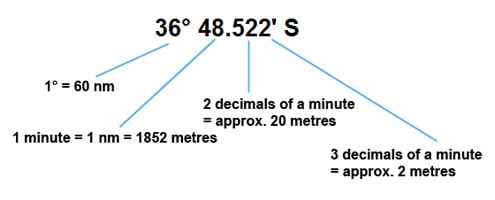
If you don't understand the differences between the different ways coordinates are given, plus how different datum come into play, you might find the article GPS Conversions by Lloyd Borrett a useful read. It describes the problems associated with locating dive sites using a GPS receiver.

Scuba Doctor Dive Map KML File
In the true spirit of making it easy to obtain, utilise and share the information for non-commercial purposes, you can now Download/view the Scuba Doctor Dive Map GPS Marks (KML file | 427.19 KB | 24-May-2022) in the Keyhole Markup Language (KML) file format used to display geographic data in an Earth browser such as Google Earth or Google Maps.
Some marine GPS units can import the information from a KML file. For others you can use use a file translate program (e.g. GPSBabel) to convert the KML file into an import file format (e.g. GPX) supported by your GPS unit.
Please Help Us To Correct GPS Marks and Add More Melbourne Dive Sites
If you have have information about other dive sites you'd be happy to see added to the information available here, or any corrections and/or updates to the diving site GPS marks listed here, please feel free to Contact Us. See also, Dive Site Help.
Copyright in photographs and other materials used here remains with their artists and authors. We are happy to acknowledge appropriate copyrights should they be made known to us.
Bass Strait Warning: Always keep an eye on sea conditions throughout any shore or boat dive in Bass Strait on Victoria's coastline. Please read the warnings on the web page Diving in Bass Strait before diving or snorkelling this site.

