West Coast Shipwreck Trail
There are approximately 638 known shipwrecks along Victoria's coast, although only around 240 of them have been discovered. The Historic Shipwreck Trail along the Shipwreck Coast and the Discovery Coast shows some of the sites where gales, human error and, in some cases, foul play caused these vessels to be wrecked.
As you tour along this rugged coastline, look for the road signs that lead to information plaques overlooking the cliffs and sandy beaches.
Each site reveals more about our maritime history in the days of sail and steam, when Bass Strait was the route to the riches of the goldfields and Portland was the gateway to a new life in Victoria.
The small coastal traders and large ships carrying vital cargo and immigrants between Europe, America and the new colonies of Australia often battled severe storms, not only in the treacherous waters of Bass Strait, but also at anchor in the precarious safety of Portland Bay.
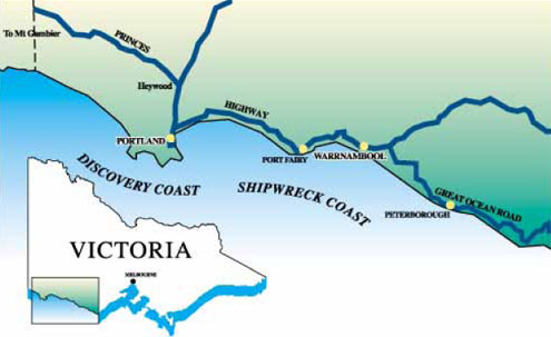
The first stage of the trail, the Shipwreck Coast from Port Fairy to Moonlight Head, was established in 1990 to highlight the importance of shipping and navigation in the development of Victoria. The second stage, the Discovery Coast between Port Fairy and the South Australian border, was opened in 1993.
Discovery Coast
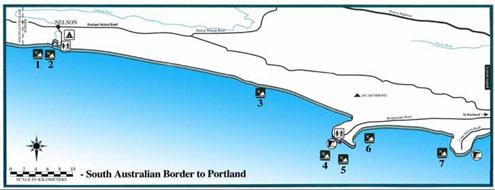
South Australian Border to Portland
Nelson
At the mouth of the Glenelg River, 5 km from the South Australian border, lies the picturesque village of Nelson. Established in the 1840s the settlement was known simply as 'The Punt', although four town blocks were gazetted in 1852 as Nelson. Since the 1830s strong southerly winds have driven many ships onto the shores of the Discovery Coast near here.
Cape Nelson Lighthouse
Because of the number of tragic shipwrecks, the Victorian Government had a lighthouse constructed at Cape Nelson in 1883. Information regarding tours of the lighthouse can be obtained from Parks Victoria.
1 — S.S. Perseverance 1890–1898 (not found)
The S.S. Perseverance was wrecked on the sandbar at the mouth of the Glenelg River whilst attempting a voyage from Nelson to the river Murray in South Australia.
2 — The Triumph 1840–1863 (not found)
The Western Australian-built schooner The Triumph disappeared whilst on a voyage from Port MacDonnell to Port Adelaide. The remains of the vessel were later found cast ashore at Discovery Bay. There were no survivors.
3 — John Ormerod 1826 - 1861 (not found)
The English-built schooner John Ormerod came ashore east of the Glenelg River mouth, after having been blown over on to its side whilst off Cape Bridgewater. Only three of the crew survived.
4 — Marie 1851 (not found)
The barque Marie, on a voyage from Antwerp to Sydney via Adelaide, was wrecked off Cape Bridgewater in September 1851. All on board, including the Belgian Consul, were drowned.
5 — Jane 1863 (not found)
Poor visibility caused the schooner Jane to be wrecked at Cape Bridgewater in June 1863. A local resident, Waldy Hedditch, was drowned during the rescue attempt.
6 — S.S. Barwon 1863–1871
The steamship SS Barwon sank in Bridgewater Bay after striking a reef off Cape Bridgewater during foggy weather. The remains of the vessel can still be seen from the cliffs overlooking the bay.
SS Barwon | Wreck Dive | Boat access |
| Latitude: 38° 22.625′ S (38.377075° S / 38° 22′ 37.47″ S) Longitude: 141° 24.704′ E (141.411729° E / 141° 24′ 42.22″ E) | ||
| Datum: WGS84 | Google Map | |
| Added: 2021-06-20 03:09:48 GMT, Last updated: 2022-05-23 08:13:39 GMT Source: GPS | ||
| Nearest Neighbour: Horseshoe Reef, 163 m, bearing 172°, S | ||
| Three-Masted Schooner Rigged Iron Screw Steamer. Built: Greenock, Scotland, 1863. Sunk: 3 April 1871. Cape Bridgewater, Discovery Coast. Depth: 5 m. | ||
| See the SS Barwon dive site page | ||
7 — Isabella 1826–1837
When Captain John Hart of the Isabella mistook Lady Julie Percy Island for Cape Nelson in 1837 he plotted a course that took the barque into the cliffs on the eastern side of Cape Nelson. All on board were saved.
Isabella, Cape Nelson | Wreck Dive | Boat access |
| Latitude: 38° 25.454′ S (38.424239° S / 38° 25′ 27.26″ S) Longitude: 141° 33.409′ E (141.556823° E / 141° 33′ 24.56″ E) | ||
| Datum: WGS84 | Google Map | |
| Added: 2021-06-20 02:15:01 GMT, Last updated: 2022-05-20 04:15:05 GMT Source: GPS (verified) | ||
| Nearest Neighbour: Devils Kitchen, 325 m, bearing 192°, SSW | ||
| Three-Masted Wooden Barque. Built: South Town, Yarmouth, 1826. Sunk: 1 April 1837. Cape Nelson, Portland, Discovery Coast. Depth: 10 m. | ||
| See the Isabella, Cape Nelson dive site page | ||
Discovery Coast
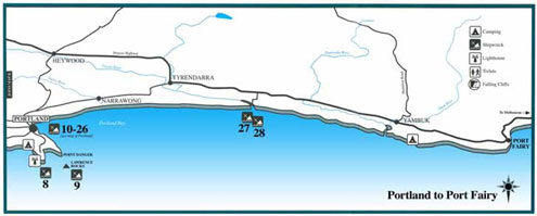
Portland to Port Fairy
8 — Captain Cook 1847–1850 (not found)
The Australian-built schooner Captain Cook was wrecked at the top of Cape Nelson Bay during a sudden southeasterly gale.
9 — Emily S 1991
The Emily S, a 30 metre long steel trawler, was sunk in 1991 off Lawrence Rocks by Professional Diving Services Dive Club Inc., to provide a safe and convenient wreck dive for sports divers.
Emily S | Wreck Dive | Boat access |
| Latitude: 38° 24.164′ S (38.402733° S / 38° 24′ 9.84″ S) Longitude: 141° 40.324′ E (141.672067° E / 141° 40′ 19.44″ E) | ||
| Datum: WGS84 | Google Map | |
| Added: 2012-07-22 01:00:00 GMT, Last updated: 2022-05-23 10:47:25 GMT Source: Marine Life Network | ||
| Nearest Neighbour: The Nursery, Lawrence Rocks, 234 m, bearing 203°, SSW | ||
| Fishing Trawler. Built: Sydney, 1946. Sunk: 1 September 1991. Lawrence Rocks, Portland, Discovery Coast. Depth: 24 m. | ||
| See the Emily S dive site page | ||
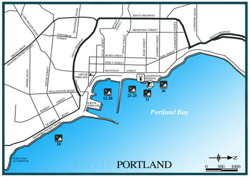
10–26 — Portland Wrecks
Portland is one of the few natural deep water ports in Australia. Bass Strait sealers are thought to have used it as a base well before the 1820s when it became an established whaling station.
Since then, with the growth of a prosperous hinterland and fishing industries, the arrival of goldseekers, immigration and, more recently, manufacturing developments, Portland has become a thriving city.
Before the construction of the breakwaters and deepwater moorings, Portland Bay was a trap for vessels at anchor. Strong south-easterly gales often caught them unprepared and drove them ashore.
There are 19 shipwrecks in Portland Bay. These vessels carried immigrants and all manner of cargoes, including timber, whaling products, potatoes, clothing, alcohol and pianos. Most have never been located.
10 — Henry 1827–1834 (not found)
The small schooner Henry became the first recorded shipwreck in Portland Bay when it was forced ashore while loading whale oil in August 1834.
11 — New Zealander 1852–1853
The immigrant ship New Zealander had discharged its 465 passengers and was undergoing repairs when it caught fire. The remains of the wreck can still be seen in the water below the Lighhouse Reserve.
New Zealander | Wreck Dive | Shore access |
| Latitude: 38° 20.287′ S (38.33812° S / 38° 20′ 17.23″ S) Longitude: 141° 36.620′ E (141.610341° E / 141° 36′ 37.23″ E) | ||
| Datum: WGS84 | Google Map | Get directions | |
| Added: 2012-07-22 01:00:00 GMT, Last updated: 2022-05-23 10:50:52 GMT Source: GPS (verified) | ||
| Nearest Neighbour: Lighthouse Reef, 239 m, bearing 224°, SW | ||
| Three-Masted Wooden Ship. Built: Pictou, Canada, 1852. Sunk: 16 December 1853. Portland Bay, Discovery Coast. Depth: 3 m. | ||
| See the New Zealander dive site page | ||
12 — Lady Robilliard 1845–1867 (not found)
The Lady Robilliard was on a voyage from Port Adelaide to Portland when a south-easterly gale drove it ashore near Whalers Bluff.
13 — Argo 1867–1883 (not found)
The 17-ton wooden cutter Argo, built in Port Fairy, was wrecked on Portland beach during a south-easterly gale on 31 December 1883.
14 — Margaret and Agnes 1850–1852 (not found)
The Victorian-built schooner Margaret and Agnes had just arrived at Portland Bay from Port Fairy with a cargo of potatoes, flour and bran, when it was blown ashore.
15 — Mary Jane 1846–1852 (not found)
Following the wreck of the Canadian-built brigantine, Mary Jane and the stranding of the schooner Brothers in May 1852, the Portland Guardian criticized the vessels' captains for anchoring too close to shore, and called on the Colonial Government to appoint a harbour master at Portland.
16 — Tui 1868–1883 (not found)
The 18-ton cutter Tui, built at Port Fairy in 1868, was reported wrecked at Portland following a south-easterly gale in 1883.
17 — Nestor 1840–1854 (not found)
The immigrant ship Nestor was lost due to foul play. After the wreck, divers discovered three holes bored in the hull. The master was later arrested and charged with scuttling his ship, but charges were dropped due to lack of evidence.
18 — Australasia 1847–1855 (not found)
Australasia and Constant were both driven ashore during a severe gale in March 1855. The Australasia was sold to the Henty brothers, who made a small fortune by salvaging the cargo of wool.
19 — Constant 1843–1855 (not found)
The Constant had just discharged its 229 immigrants before being blown ashore during a storm, possibly because of poor anchors.
20 — Regia 1835–1860
The remains of the Indian-built barque Regia, grounded during a severe gale, can still be seen lying in two metres of water next to the reclaimed land on the Portland foreshore.
Regia | Wreck Dive | Shore access |
| Latitude: 38° 20.707′ S (38.345116° S / 38° 20′ 42.42″ S) Longitude: 141° 36.453′ E (141.607558° E / 141° 36′ 27.21″ E) | ||
| Datum: WGS84 | Google Map | Get directions | |
| Added: 2021-07-26 14:52:22 GMT, Last updated: 2022-05-24 04:48:39 GMT Source: GPS (verified) | ||
| Nearest Neighbour: Portland Lee Breakwater, 212 m, bearing 12°, NNE | ||
| Two-Masted Wooden Brig. Built: Cochin, India, 1835. Sunk: 16 November 1860. Portland Harbour, Discovery Coast. Depth: 2 m. | ||
| See the Regia dive site page | ||
21 — Tamora 1853–1860 (not found)
The wooden barque Tamora blew ashore in a gale while unloading cargo. Portland police charged some people with theft from the vessel, including the master of the schooner Eva, which was wrecked in the same gale.
22 — Elizabeth 1837–1844 (not found)
The Tasmanian-built schooner Elizabeth and another schooner, Sally Ann, were driven ashore during a south-easterly gale in Portland Bay in mid-November 1844.23 — Elizabeth 1838–1846 (not found)
The Canadian-built brig Elizabeth was totally wrecked on the beach directly below the Portland town site during a south-easterly gale in November 1846.
24 — Henry 1853 (not found)
According to some sources, the two-masted schooner Henry, built specifically to trade between Melbourne and Portland, went ashore during a gale at Portland in September 1853 and became a total wreck.
25 — Sally Ann 1826–1844 (not found)
The Bermudan-built schooner Sally Ann, owned by Stephen Henty, was a regular visitor to Portland. She was driven ashore in a south-easterly gale in mid-November 1844, along with the schooner Elizabeth.
26 — Merope's boat 1839 (not found)
One of the earliest recorded wrecks in Portland Bay was that of a small boat from the barque Merope. It struck a reef while the crew was hunting whales off Lawrence Rocks in May 1839.
27 — Julia 1840–1863
When the brig Julia was grounded near the mouth of the Fitzroy River in 1863, all members of the crew were saved, but six whalers assisting the rescue were drowned.
28 — Merope 1818–1853 (not found)
The Indian-built sailing ship Merope survived a stranding in Western Australia before coming to grief after striking a reef east of the Fitzroy River mouth in 1853.
Shipwreck Coast
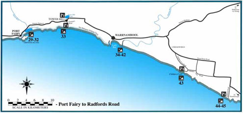
Port Fairy to Radfords Road
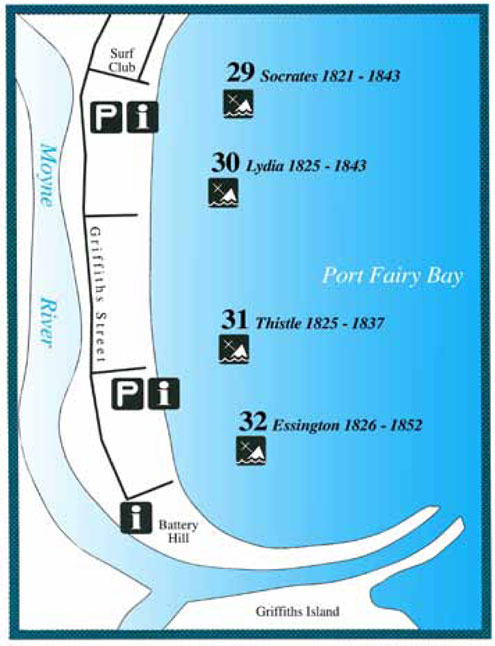
29–33 — Port Fairy Wrecks
Port Fairy at the mouth of the Moyne River, one of Victoria's earliest settlements, began as a whaling station. Twenty ships were lost at Port Fairy when driven ashore by southerly gales between 1836 and 1876. During this period, Port Fairy grew from a sealing and whaling base to a thriving rural port.
29 — Socrates 1821–1843
The British built whaler Socrates was wrecked with its cargo of cattle, sheep and oil from Tasmania when its cable parted during an easterly gale.
Socrates | Wreck Dive | Shore access |
| Latitude: 38° 22.853′ S (38.380888° S / 38° 22′ 51.2″ S) Longitude: 142° 14.677′ E (142.244612° E / 142° 14′ 40.6″ E) | ||
| Datum: WGS84 | Google Map | Get directions | |
| Added: 2021-06-18 04:06:03 GMT, Last updated: 2022-05-23 11:10:13 GMT Source: GPS (verified) | ||
| Nearest Neighbour: Lydia, 162 m, bearing 176°, S | ||
| Three-Masted Wooden Barque. Built: Scarborough, UK, 1821. Sunk: 31 August 1843. Port Fairy, Shipwreck Coast. Depth: 1 to 3 m. | ||
| See the Socrates dive site page | ||
30 — Lydia 1825–1843
The Liverpool-built South American trader Lydia was sailing from Sydney to London in ballast when lost after running ashore.
Lydia | Wreck Dive | Shore access |
| Latitude: 38° 22.940′ S (38.38234° S / 38° 22′ 56.42″ S) Longitude: 142° 14.684′ E (142.244726° E / 142° 14′ 41.01″ E) | ||
| Datum: WGS84 | Google Map | Get directions | |
| Added: 2021-06-18 05:14:13 GMT, Last updated: 2022-05-23 11:08:24 GMT Source: GPS (verified) | ||
| Nearest Neighbour: Socrates, 162 m, bearing 356°, N | ||
| Three-Masted Wooden Barque. Built: Liverpool, UK, 1825. Sunk: 2 February 1847. Port Fairy, Shipwreck Coast. Depth: 1 to 3 m. | ||
| See the Lydia dive site page | ||
31— Thistle 1825–1837
The Indian-built schooner Thistle, owned by the Hentys, was wrecked when its crew was collecting wattle bark during the off-season from whaling.
Thistle, Port Fairy | Wreck Dive | Shore access |
| Latitude: 38° 23.044′ S (38.384067° S / 38° 23′ 2.64″ S) Longitude: 142° 14.615′ E (142.243583° E / 142° 14′ 36.9″ E) | ||
| Datum: WGS84 | Google Map | Get directions | |
| Added: 2021-06-18 08:30:10 GMT, Last updated: 2022-05-23 11:12:13 GMT Source: GPS (verified) | ||
| Nearest Neighbour: Lydia, 216 m, bearing 27°, NNE | ||
| Two-Masted Wooden Brigantine. Built: Fort Gloster, Bengal, 1825. Sunk: 25 December 1837. Port Fairy, Shipwreck Coast. Depth: 3 m. | ||
| See the Thistle, Port Fairy dive site page | ||
32 — Essington 1826–1852
Government-built in Sydney as a troop and convict transport, the Essington was privately owned when wrecked in a gale while carrying general cargo from Sydney.
Essington | Wreck Dive | Shore access |
| Latitude: 38° 23.217′ S (38.386945° S / 38° 23′ 13″ S) Longitude: 142° 14.617′ E (142.243612° E / 142° 14′ 37″ E) | ||
| Datum: WGS84 | Google Map | Get directions | |
| Added: 2012-07-22 01:00:00 GMT, Last updated: 2022-05-23 11:06:01 GMT Source: GPS | ||
| Nearest Neighbour: Thistle, Port Fairy, 320 m, bearing 359°, N | ||
| Two-master wooden brig. Built: Government Dockyard, Sydney, 1826. Sunk: 3 May 1852. Port Fairy, Shipwreck Coast. Depth: 11 m. | ||
| See the Essington dive site page | ||
33 — Mahogany Ship 1836 (not found)
In the early nineteenth century there were several sightings of an 'ancient wreck' in dunes between Port Fairy and Warrnambool. Hypotheses about its identity vary from 'sixteenth century Portuguese caravel' to 'early American sealing vessel'. This mysterious Mahogany Ship wreck has not been found despite extensive searches and the offer of a government reward of $250,000 in 1992–93. The Mahogany Walking Track goes from Port Fairy to Warrnambool.
See also, The Mahogany Ship Story: Re-examining the Evidence (Adobe PDF | 2.78 MB) — May 2009.
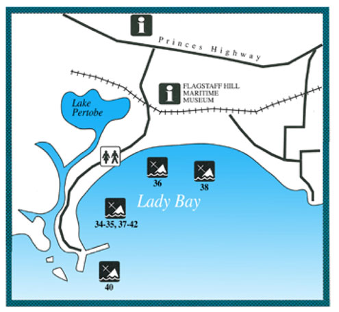
34–42 — Warrnambool Wrecks
There are 15 shipwrecks in Lady Bay dating from 1850�1905. Their cargoes of potatoes, wheat, coal and timber reveal Warrnambool's expansion as a centre of rural trade.
34 — Enterprise 1847–1850 (not found)
The New Zealand-built schooner Enterprise had sailed from Melbourne and was anchored in Lady Bay, Warrnambool when a south easterly gale swept in on 14 September 1850. The vessel began to drag its anchor, grounded, then went broadside onto the beach. A local Aborigine, Buckawall, struggled through the rough sea from the shore and secured a line to the Enterprise, allowing the crew to land safely. The vessel became a total wreck.
35 — Golden Spring 1848–1863 (not found)
Built in Maine, USA in 1848, the brig Golden Spring was registered in Sydney from 1858. The vessel was anchored in Lady Bay when a gale blew up, causing it to drag anchor and strike the wreck of the Maid of Julpha, located some 150 metres off shore in the bay. The Golden Spring soon broke in two. The gale was noted as the worst that had been record in Warrnambool at this time. The sloop Peveril was wrecked in the same gale.
36 — Free Trader 1850–1894
The Tasmanian-built barque Free Trader parted from both its main anchors during a sudden gale at Warrnambool in July 1984; it was in ballast at the time, pending a voyage to Newcastle. The remaining anchor dragged, and the vessel drifted towards the beach, going broadside onto the piling at the swimming baths. The piling soon battered a hole through the hull, and the vessel filled with water. The crew escaped by climbing onto the piling, but the 44 year old Free Trader became a total wreck. The site is probably deeply buried under the sand in the intertidal zone south west of the Surf Life Saving Club.
Free Trader | Wreck | Shore access |
| Latitude: 38° 23.648′ S (38.394137° S / 38° 23′ 38.89″ S) Longitude: 142° 28.916′ E (142.481936° E / 142° 28′ 54.97″ E) | ||
| Datum: WGS84 | Google Map | Get directions | |
| Added: 2022-05-18 02:01:57 GMT, Last updated: 2022-05-23 21:52:33 GMT Source: Peter Ronald GPS | ||
| Nearest Neighbour: Warrnambool Breakwater Inside, 1,049 m, bearing 209°, SSW | ||
| Three-Masted Wooden Barque. Built: Hobart Town, 185. Sunk: 22 July 1894. Lady Bay, Warrnambool, Shipwreck Coast. Depth: 0 m. | ||
| See the Free Trader dive site page | ||
38 — Edinburgh Castle 1863–1888
The Scottish barque Edinburgh Castle wrecked in 1888 near the mouth of the Hopkins River in Lady Bay. The ship was carrying an important cargo of cement from London for construction of the Warrnambool breakwater. Pilot error caused the ship to run aground despite the calm weather and it settled in sand, foiling efforts to refloat it. The remains of the ship were scattered in the surf and the site is now buried, but occasionally becomes exposed during rough weather.
Edinburgh Castle | Wreck Dive | Boat access |
| Latitude: 38° 23.953′ S (38.39922° S / 38° 23′ 57.19″ S) Longitude: 142° 29.885′ E (142.49808° E / 142° 29′ 53.09″ E) | ||
| Datum: WGS84 | Google Map | |
| Added: 2012-07-22 01:00:00 GMT, Last updated: 2022-05-23 11:19:14 GMT Source: GPS (verified) | ||
| Nearest Neighbour: Hopkins Reef, 1,239 m, bearing 141°, SE | ||
| Three-Masted Iron Barque. Built: Glasgow, Scotland, 1863. Sunk: 15 January 1888. Lady Bay, Warrnambool, Shipwreck Coast. Depth: 5 m. | ||
| See the Edinburgh Castle dive site page | ||
39 — Whaleboat unknown 1836 (not found)
In the winter of 1836 a whaleboat swamped and sank while entering the Hopkins River. One of the three whaleboat crew drowned in the incident. Further tragedy struck when another boat, captained by John Mills, overturned while trying to recover the whaleboat. The site has yet to be found or identified.
40 — La Bella 1893–1905
The Norwegian-built barquentine La Bella was approaching Warrnambool with a cargo of timber from Kaipara, New Zealand, in heavy seas and evening mist when it ran aground on what is now known as La Bella Reef. By sunrise only seven of the 12 crew still clung to the wreck. A local fisherman, William Ferrier, rowed his small punt through heavy seas to rescue two of the crew, including the captain, whilst the volunteer lifeboat crew rescued a further three before La Bella broke in half and sank. William Ferrier was 25 years old at the time, and was awarded the Silver Medal of the Royal Humane Society for his daring rescue. The wreck now lies in 13m of water and is home to an abundance of marine life.
La Bella | Wreck Dive | Boat access |
| Latitude: 38° 24.254′ S (38.404232° S / 38° 24′ 15.24″ S) Longitude: 142° 28.889′ E (142.481483° E / 142° 28′ 53.34″ E) | ||
| Datum: WGS84 | Google Map | |
| Added: 2012-07-22 01:00:00 GMT, Last updated: 2022-05-24 04:47:38 GMT Source: GPS (verified) | ||
| Nearest Neighbour: Old Aquarium, 501 m, bearing 276°, W | ||
| Three-Masted Steel Barquentine Ship. Built: Norway, 1893. Sunk: 10 November 1905. Warrnambool, Shipwreck Coast. Depth: 13 m. | ||
| See the La Bella dive site page | ||
41 — Freedom 1841–1853 (not found)
The Freedom was a two-masted schooner built in Jersey, England. It was carrying a cargo of wheat, barley and flour bound for Sydney when it was driven ashore at Warrnambool by a south easterly gale. Although refloated, another gale drove the vessel ashore again on 11 October 1853. This time the anchors parted and the ship was blown ashore near the jetty where it became a total wreck. The site has not been located.
42 — Yarra 1850–1882 (not found)
The Yarra was built in Hobart, Tasmania as a two-masted brigantine. It was waiting to unload a cargo of coal from Newcastle when the anchors parted in heavy swell and the ship drifted out of control across Lady Bay. The Yarra first collided with the SS Dawn, before grounding east of the jetties, where it broke up the following day. The site was later dynamited as it was a navigation hazard, and the remains of the site have not been located.
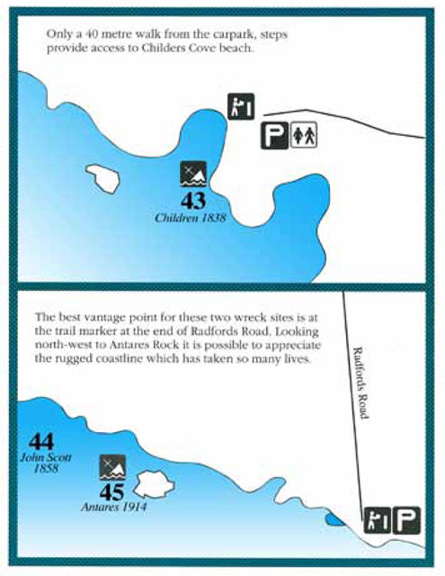
43–45 — Children, John Scott and Antares Wrecks
Just a 40 metre walk from the carpark, steps provide acces to Childers Cove beach.
The best vantage point for the John Scott and Antares is at the trail marker at the end of Radfords Road. Looking north-west to Andares Rock it is possible to appreciate the rugged coastline which has taken so many lives.
43 — Children 1825–1839
The Children was a coastal trader owned by the Henty family of Portland. On a voyage from Launceston in January 1839, it was blown off course and struck a reef at the mouth of Childers cove. Sixteen people were drowned.
Children | Wreck Dive | Shore access |
| Latitude: 38° 29.439′ S (38.490657° S / 38° 29′ 26.37″ S) Longitude: 142° 40.349′ E (142.672482° E / 142° 40′ 20.94″ E) | ||
| Datum: WGS84 | Google Map | Get directions | |
| Added: 2012-07-22 01:00:00 GMT, Last updated: 2022-05-23 11:25:55 GMT Source: GPS (verified) | ||
| Nearest Neighbour: Childers Cove, 153 m, bearing 23°, NNE | ||
| Three-Masted Wooden Barque. Built: Liverpool, England, 1824. Sunk: 14 January 1839. Childers Cove, Shipwreck Coast. Depth: 3 m. | ||
| See the Children dive site page | ||
44 — John Scott 1848–1858
The John Scott was on a voyage from Adelaide to Melbourne with a cargo of flour and wheat when heavy seas and fog caused the vessel to come ashore at Bold Projection. The crew and passengers were all saved.
John Scott | Wreck Dive | Shore access |
| Latitude: 38° 32.043′ S (38.534043° S / 38° 32′ 2.55″ S) Longitude: 142° 44.197′ E (142.736618° E / 142° 44′ 11.82″ E) | ||
| Datum: WGS84 | Google Map | Get directions | |
| Added: 2022-05-18 07:47:25 GMT, Last updated: 2022-05-23 11:29:05 GMT Source: Peter Ronald GPS | ||
| Nearest Neighbour: Antares, 3,250 m, bearing 134°, SE | ||
| Two-Masted Wooden Snow. Built: Hylton, England, 1848. Sunk: 14 February 1858. Bold Projection, Flaxmans Hill, Shipwreck Coast. Depth: 3 m. | ||
| See the John Scott dive site page | ||
45 — Antares 1888–1914
The Antares was the last sailing ship wrecked along the Shipwreck Coast. On a voyage from Marseilles to Melbourne during World War I, the vessel sank with the loss of all hands.
Antares | Wreck Dive | Boat access |
| Latitude: 38° 33.268′ S (38.554462° S / 38° 33′ 16.06″ S) Longitude: 142° 45.801′ E (142.763351° E / 142° 45′ 48.06″ E) | ||
| Datum: WGS84 | Google Map | |
| Added: 2012-07-22 01:00:00 GMT, Last updated: 2022-05-21 12:30:21 GMT Source: GPS (verified) | ||
| Nearest Neighbour: John Scott, 3,250 m, bearing 314°, NW | ||
| Three-Masted Iron Barque, 1742 ton. Built: Glasgow, Scotland, 1888. Sunk: November 1914. Bay of Islands, Shipwreck Coast. Depth: 2 to 6 m. | ||
| See the Antares dive site page | ||
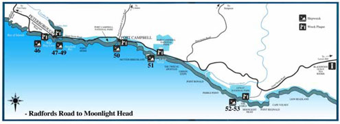
Radfords Road to Moonlight Head
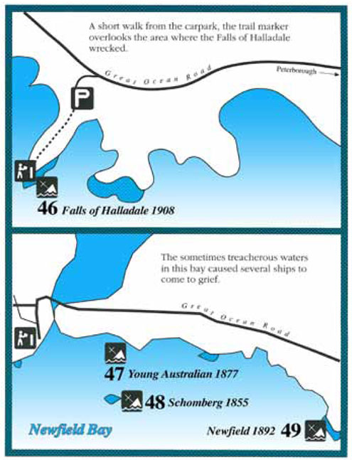
46–49 — Peterborough Wrecks
A short walk from the carpark, the trail marker overlooks the area where the Falls of Halladale wrecked.
The sometimes treacherous waters in Newfield Bay caused several ships to come to grief.
46 — Falls of Halladale 1886–1908
The Falls of Halladale was on the final leg of its voyage from New York to Melbourne when its captain became unsure of his location due to the presence of sea mist. The vessel, with all its sails set, struck a reef and became a total loss.
Falls of Halladale | Wreck Dive | Boat access |
| Latitude: 38° 36.428′ S (38.607139° S / 38° 36′ 25.7″ S) Longitude: 142° 51.434′ E (142.857225° E / 142° 51′ 26.01″ E) | ||
| Datum: WGS84 | Google Map | |
| Added: 2012-07-22 01:00:00 GMT, Last updated: 2022-05-23 11:42:42 GMT Source: Peter Ronald GPS | ||
| Nearest Neighbour: Nursery Bay, 573 m, bearing 67°, ENE | ||
| Four-Masted Iron Barque. Built: Greenock, Scotland, 1886. Sunk: 14 November 1908. Peterborough, Shipwreck Coast. Depth: 18 m. | ||
| See the Falls of Halladale dive site page | ||
47 — Young Australian 1864–1877 (not found)
The Young Australian was on a voyage from Queensland to Adelaide with a cargo of sugar and rum when severe storms damaged the ship�s rigging and forced it ashore.
48 — Schomberg 1855–1855
The Schomberg was one of the most magnificent sailing ships ever built. Captain 'Bully' Forbes was below deck entertaining female passengers when the vessel was blown ashore at Curdies Inlet. Both the ship and the Captain's career were wrecked.
Schomberg | Wreck Dive | Boat access |
| Latitude: 38° 37.043′ S (38.617376° S / 38° 37′ 2.55″ S) Longitude: 142° 53.574′ E (142.892905° E / 142° 53′ 34.46″ E) | ||
| Datum: WGS84 | Google Map | |
| Added: 2012-07-22 01:00:00 GMT, Last updated: 2022-05-23 11:44:18 GMT Source: GPS (verified) | ||
| Nearest Neighbour: Newfield, 1,149 m, bearing 92°, E | ||
| Three-Masted Wooden Clipper Ship. Built: Aberdeen, Scotland, 1855. Sunk: 26 December 1855. Peterborough, Newfield Bay, Shipwreck Coast. Depth: 10 m. | ||
| See the Schomberg dive site page | ||
49 — Newfield 1889–1892
Poor weather conditions and faulty navigation caused the loss of the barque Newfield while on a voyage from Scotland to Brisbane. The ship was blown ashore at Peterborough with the loss of nine lives.
Newfield | Wreck Dive | Boat access |
| Latitude: 38° 37.066′ S (38.617766° S / 38° 37′ 3.96″ S) Longitude: 142° 54.367′ E (142.906121° E / 142° 54′ 22.04″ E) | ||
| Datum: WGS84 | Google Map | |
| Added: 2012-07-22 01:00:00 GMT, Last updated: 2022-05-18 03:05:43 GMT Source: GPS (verified) | ||
| Nearest Neighbour: Schomberg, 1,149 m, bearing 272°, W | ||
| Three-Masted Iron Sailing Barque. Built: Dundee, Scotland, 1889. Sunk: 29 August 1892. Shipwreck Coast. Depth: 7 m. | ||
| See the Newfield dive site page | ||
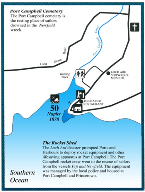
50 — Napier Wreck
Port Campbell Cemetery
The Port Campbell cemetery is the resting place of sailors drowned in the newfield wreck.
50 — Napier 1874–1878
The steamship Napier was engaged to salvage the wreck of the Loch Ard, but came to grief while entering Port Campbell inlet.
Napier | Wreck Dive | Shore access |
| Latitude: 38° 37.248′ S (38.620803° S / 38° 37′ 14.89″ S) Longitude: 142° 59.376′ E (142.989599° E / 142° 59′ 22.56″ E) | ||
| Datum: WGS84 | Google Map | Get directions | |
| Added: 2021-05-28 11:39:55 GMT, Last updated: 2022-05-23 12:15:35 GMT Source: Google Earth | ||
| Nearest Neighbour: Port Campbell Jetty, 177 m, bearing 98°, E | ||
| Built: Goolwa, South Australia, 1874. Sunk: 16 September 1878. Port Campbell Bay, Shipwreck Coast. Depth: 8 m. | ||
| See the Napier dive site page | ||
51 — Loch Ard 1873–1878
The Loch Ard was on the final stage of its voyage from Gravesend to Melbourne when sea mist obscured the land causing the vessel to run into Mutton Bird Island near Port Campbell. Of the 54 people on board the ship, only two managed to get ashore.
Loch Ard | Wreck Dive | Boat access |
| Latitude: 38° 39.007′ S (38.650109° S / 38° 39′ 0.39″ S) Longitude: 143° 3.722′ E (143.062039° E / 143° 3′ 43.34″ E) | ||
| Datum: WGS84 | Google Map | |
| Added: 2012-07-22 01:00:00 GMT, Last updated: 2022-05-23 12:17:10 GMT Source: Peter Ronald GPS | ||
| Nearest Neighbour: The Blowhole, Port Campbell, 283 m, bearing 4°, N | ||
| Three-Masted Iron Clipper Ship. Built: Glasgow, Scotland, 1873. Sunk: 1 June 1878. Twelve Apostles Marine National Park. Mutton Bird Island, Port Campbell, Shipwreck Coast. Depth: 25 m. | ||
| See the Loch Ard dive site page | ||
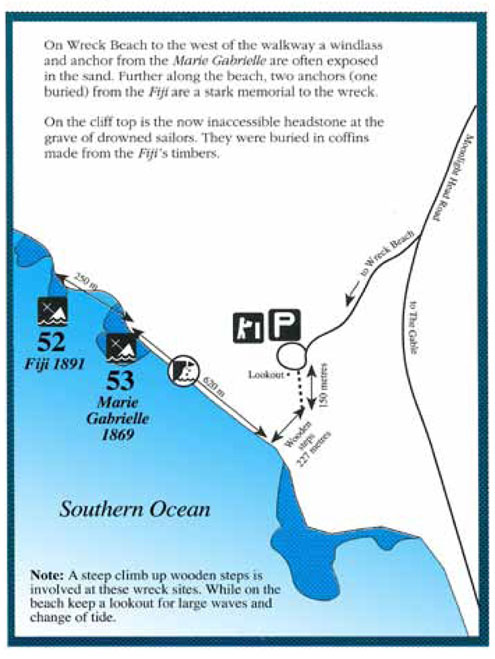
52–53 — Fiji and Marie Gabrielle Wrecks
On Wreck Beach to the west of the walkway a windlass and anchor from the Marie Gabrielle are often exposed in the sand. Further alond the beach, two anchors (one buried) from the Fiji are a stark memorial to the wreck.
On the clifftop is the now inaccessible headstone at the grave of the drowned sailors. They were buried in coffins made from the Fiji's timbers.
52 — Fiji 1875–1891
The wreck of the barque Fiji was caused by poor weather and faulty navigational equipment. The ship was wrecked at Wreck Beach near Moonlight Head during a voyage from Hamburg to Melbourne.
Lifesaving gear was sent from Port Campbell in two buggies, the first containing the tripod and four rockets, and a lifeboat, the second the heavy rope and (bosun's) chair. It is strongly suspected that a local photographer took the heavy rope out and put his camera gear in. When they got down to the wreck they found that half the rocket apparatus was missing. It was needed to fire the heavy rope on to the wreck so that the people could get off, hand over hand, to the shore. Without this rope, 12 of the crew of 27 died.
Fiji | Wreck Dive | Boat access |
| Latitude: 38° 45.165′ S (38.752754° S / 38° 45′ 9.91″ S) Longitude: 143° 12.289′ E (143.204811° E / 143° 12′ 17.32″ E) | ||
| Datum: WGS84 | Google Map | |
| Added: 2012-07-22 01:00:00 GMT, Last updated: 2022-05-23 12:19:08 GMT Source: GPS | ||
| Nearest Neighbour: Marie Gabrielle, 327 m, bearing 117°, ESE | ||
| Three-Masted Iron Barque. Built: Belfast, Ireland, 1875. Sunk: 6 September 1891. Moonlight Head, Shipwreck Coast. Depth: 7 m. | ||
| See the Fiji dive site page | ||
53 — Marie Gabrielle 1864–1869
While carrying tea from China to Melbourne, the barque Marie Gabrielle was blown off course and driven ashore at Wreck Beach near Moonlight Head. Despite the southwesterly gale, all hands were saved.
Marie Gabrielle | Wreck Dive | Boat access |
| Latitude: 38° 45.246′ S (38.7541° S / 38° 45′ 14.76″ S) Longitude: 143° 12.490′ E (143.208161° E / 143° 12′ 29.38″ E) | ||
| Datum: WGS84 | Google Map | |
| Added: 2021-08-16 01:07:55 GMT, Last updated: 2022-05-23 12:19:58 GMT Source: Google Earth | ||
| Nearest Neighbour: Fiji, 327 m, bearing 297°, WNW | ||
| Three-masted wooden barque. Built: Nantes, France, 1864. Sunk: 25 November 1869. Wreck Beach, Moonlight Head, Shipwreck Coast. Depth: 3 m. | ||
| See the Marie Gabrielle dive site page | ||
See also Guide to the Historic Shipwreck Trail on Victoria's West Coast (Adobe PDF | 1015.75 KB)
Shipwrecks of South-west Victoria | Source: Flagstaff Hill Maritime Museum
Heritage Warning: Any shipwreck or shipwreck relic that is 75 years or older is protected by legislation. Other items of maritime heritage 75 years or older are also protected by legislation. Activities such as digging for bottles, coins or other artefacts that involve the disturbance of archaeological sites may be in breach of the legislation, and penalties may apply. The legislation requires the mandatory reporting to Heritage Victoria as soon as practicable of any archaeological site that is identified. See Maritime heritage. Anyone with information about looting or stolen artefacts should call Heritage Victoria on (03) 7022 6390, or send an email to [email protected].

