Navigation
These technical diving packages from The Scuba Doctor offer peace of mind and a large saving compared to buying the dive components individually.
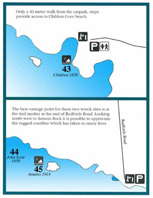
Children
![]() Wreck Dive |
Wreck Dive | ![]() Shore access
Shore access
![]()
![]()
![]()
Three-Masted Wooden Barque | Max Depth: 3 m (9.84 ft)
Level: Open Water and beyond.
One of the first vessels to be lost in the Western District was the wooden barque Children, a coastal trader owned by the Henty family of Portland. The Children was wrecked on 14 January 1839 when the vessel ran ashore in hurricane-force winds at the entrance to Childers Cove, 30 km west of Peterborough, to the east of Warrnambool on Victoria's Shipwreck Coast. The Children broke up within 30 minutes, sweeping sixteen of those on board to their deaths. After eleven days, the survivors, all of whom were injured, were rescued and taken to Portland.
Much of the ruins of the Children has been destroyed by the constant movement of the sea beneath the cliffs. The exact date of the wreck's discovery is not known, and skeletons have been found exposed in shifting sands at Childers Cove. The Children was declared a Historic Shipwreck in 1982.
The hull structure has broken up, leaving few visible remains, except for piles of house bricks intended for the Henty's at Portland.
Shipwrecks of South-west Victoria | Source: Flagstaff Hill Maritime Museum
Children Shipwreck History — Built in 1824
The Children was a 255-ton three-masted barque with a wooden hull built in 1824, at Liverpool, England. The vessel was 92.23 ft (28 m) long, with a 25 ft (7.62 m) beam and 16.6 ft (5.06 m) draught.
She was bought by the Henty family of Portland in 1837 for regular coastal trading between Van Diemens Land, the Port Phillip District of New South Wales and South Australia.
Children Sinking — 14 January 1839
Under the command of Captain Browne, the Children left Launceston on 11th January 1839 on her first voyage to Adelaide. The cargo consisted of 1,500 sheep, horses, bullocks, farming implements, building materials and provisions. Twenty-four passengers, including two families, four shepherds and a crew of fifteen, were also on board.
The Children was caught in hurricane-force north-westerly winds and stood off the Victorian coast. When the winds subsided, the captain, who had not slept for four days, went below to sleep and left the second mate in charge as the first mate had become sick. Unfortunately, Browne had misjudged the distance from the mainland.
On the 14th January 1839, many miles north and east of the captain's navigated position, the Children struck a single rock, know as Needle Rock (aka the Pinnacle), that stood in the eastern part of Childers cove, situated between Warrnambool and Peterborough. (This rock collapsed in 1985.) Within half an hour the ship was completely destroyed.
Those on board were washed away one by one as the Children fell apart and disappeared in two hours. Of the 24 passengers and 14 crew on board only 22 survived. The captain and first mate, three sailors were lost as were two men passengers, one lady and eight children. By daylight, the survivors were huddled together on the beach, amid the bodies of their companions and animal carcasses. One man, whose foot had been smashed by an anchor when the deck gave way, had a toe amputated with a knife as he lay on the beach. The survivors were finally taken by horse and cart to Campbell's farm, near the whaling station at Port Fairy.
In 1931 shifting sands at Childers Cove uncovered the skeleton of an adult male. In 1951 another two skeletons were exposed by storms, an adult male and a child. In 1963 some district scuba divers retrieved a small signal cannon from the site. The Children anchor was raised from the wreck site by Flagstaff Hill Divers on Sunday 3rd January 1974. It is now on display near the entrance to the Flagstaff Hill Maritime Village and Museum in Warrnambool.
Childers Cove is not named after the disastrous shipwrecked, it is named after H.C.E. Childers, the founder of the University of Melbourne.
See also, west-coast-shipwreck-trail,
Heritage Council Victoria: Children, and
Australian National Shipwreck Database: Children.
Heritage Warning: Any shipwreck or shipwreck relic that is 75 years or older is protected by legislation. Other items of maritime heritage 75 years or older are also protected by legislation. Activities such as digging for bottles, coins or other artefacts that involve the disturbance of archaeological sites may be in breach of the legislation, and penalties may apply. The legislation requires the mandatory reporting to Heritage Victoria as soon as practicable of any archaeological site that is identified. See Maritime heritage. Anyone with information about looting or stolen artefacts should call Heritage Victoria on (03) 7022 6390, or send an email to heritage.victoria@delwp.vic.gov.au.
Finding the Children Shipwreck
Over the years we've been provided with different GPS marks for the Children. The GPS marks we know of in circulation for the Children are:
- GPS (verified):
Latitude: 38° 29.439′ S (38.490656738336° S / 38° 29′ 26.36″ S)
Longitude: 142° 40.349′ E (142.67248208388° E / 142° 40′ 20.94″ E) - Unknown GPS:
Latitude: 38° 29.500′ S (38.491667° S / 38° 29′ 30″ S)
Longitude: 142° 29.140′ E (142.485667° E / 142° 29′ 8.4″ E)
16,259 m, bearing 269°, W
Traditional Owners — This dive site is in the traditional Country of the Eastern Maar people of south-western Victoria between the Shaw and Eumerella Rivers and from Yambuk in the south to beyond Lake Linlithgow in the north. This truly ancient Country extends as far north as Ararat and encompasses the coastal townships of Port Fairy in the west, Warrnambool, Peterborough, Port Campbell, Apollo Bay, Lorne, and Airies Inlet in the east, including the Great Ocean Road area. It also stretches 100 metres out to sea from low tide and therefore includes the iconic Twelve Apostles. "Eastern Maar" is a name adopted by the people who identify as Maar, Eastern Gunditjmara, Tjap Wurrung, Peek Whurrong, Kirrae Whurrung, Kuurn Kopan Noot and/or Yarro waetch (Tooram Tribe) amongst others. We wish to acknowledge the Eastern Maar as Traditional Owners. We pay respect to their Ancestors and their Elders, past, present and emerging.
Children Location Map
Latitude: 38° 29.439′ S (38.490657° S / 38° 29′ 26.37″ S)
Longitude: 142° 40.349′ E (142.672482° E / 142° 40′ 20.94″ E)
Datum: WGS84 |
Google Map
| Get directions
Added: 2012-07-22 09:00:00 GMT, Last updated: 2022-05-23 19:25:55 GMT
Source: GPS (verified)
Nearest Neighbour: Childers Cove, 153 m, bearing 23°, NNE
Three-Masted Wooden Barque.
Built: Liverpool, England, 1824.
Sunk: 14 January 1839.
Childers Cove, Shipwreck Coast.
Depth: 3 m.
[ Top ]
DISCLAIMER: No claim is made by The Scuba Doctor as to the accuracy of the dive site coordinates listed here. Should anyone decide to use these GPS marks to locate and dive on a site, they do so entirely at their own risk. Always verify against other sources.
The marks come from numerous sources including commercial operators, independent dive clubs, reference works, and active divers. Some are known to be accurate, while others may not be. Some GPS marks may even have come from maps using the AGD66 datum, and thus may need be converted to the WGS84 datum. To distinguish between the possible accuracy of the dive site marks, we've tried to give each mark a source of GPS, Google Earth, or unknown.
Copyright © 2005-2022 by The Scuba Doctor Australia, ABN 88 116 755 170. All rights reserved.
tel. +61 3 5985 1700 :: email. diveshop@scubadoctor.com.au :: Web site by it'sTechnical 2022







![Halcyon Infinity 30lb System [SS Small Backplate] Halcyon Infinity 30lb System [SS Small Backplate]](/diveshop/images/halcyon/Halcyon-Evolve-Wing.jpg)


