Navigation
The Scuba Doctor dive shop has Low Cut Dive Boots for that comfortable, protective fit when scuba diving. We have a complete assortment of diving footwear that is both attractive and affordable.
Foig a Ballagh
![]() Wreck Dive |
Wreck Dive | ![]() Boat access
Boat access
![]()
![]()
![]()
Three-Masted Wooden Barque | Max Depth: 3 m (9.84 ft)
Level: Open Water and beyond.
The Foig a Ballagh, which lies between Coles and West Channel, Port Phillip, is representative of one of the small trading sailing vessels, carrying essential goods into and out of Melbourne during the nineteenth century.
Coal was becoming an indispensable commodity in Victoria from the 1850s onwards with the development of the railways and the new steamships that were becoming increasingly popular and Foig-a-Ballagh was a coal-carrying trader. Foig-a-Ballagh potentially has archaeological significance for Irish shipbuilding techniques as it is possible the bow is reasonably well preserved under the sand. The vessel holds potential significance as a training site for maritime archaeology students.
Foig a Ballagh Shipwreck History — Built in 1845
Foig a Ballagh was a three-masted wooden barque of 162 l-ton (165 t), built in 1845, in Belfast, Ireland. Built on a length of 93.4 ft (28 m), a breadth of 21.7 ft (6.61 m), and a depth of 9.3 ft (2.83 m). The vessel was carvel built, with a square stern, and registered in Sydney to owner Edward Davies in 1852. The Foig a Ballagh had previously been named Jesse when under its earlier foreign ownership.
Foig a Ballagh Sinking — 6 August 1852
On its final voyage, the Foig a Ballagh was inward bound to Melbourne from Sydney, with a cargo of coal, a number of passengers and approximately 10 crew, under the command of Captain James Wilson. It was reported that after successfully passing through The Heads, the Foig a Ballagh made its way up the West Channel until the freshening easterly winds made it too dangerous to proceed. It was decided to anchor in the channel for the night. Unfortunately, around 8:00 p.m. on the 6 August 1852, the vessel parted from its anchors and was driven ashore on the western bank of the West Channel, where it remained hard and fast.
Within a short time it was realise that the Foig a Ballagh would not be got off as it had filled with water, indicating serious hull damage below. The crew and some passengers remained on board to salvage as much as possible from the stricken vessel. The remainder of the passengers were taken on to Melbourne by the Panama.
It was reported that the master of the Foig a Ballagh remained standing for almost a decade after its loss.
See also, Australian National Shipwreck Database: Foig-A-Ballagh, and
Heritage Council Victoria: Foig a Ballagh.
Heritage Warning: Any shipwreck or shipwreck relic that is 75 years or older is protected by legislation. Other items of maritime heritage 75 years or older are also protected by legislation. Activities such as digging for bottles, coins or other artefacts that involve the disturbance of archaeological sites may be in breach of the legislation, and penalties may apply. The legislation requires the mandatory reporting to Heritage Victoria as soon as practicable of any archaeological site that is identified. See Maritime heritage. Anyone with information about looting or stolen artefacts should call Heritage Victoria on (03) 7022 6390, or send an email to heritage.victoria@delwp.vic.gov.au.
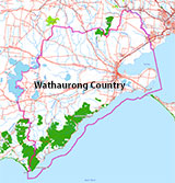
Traditional Owners — This dive site is in the traditional Country of the Wathaurong (Wadda-Warrung) people of the Kulin Nation. This truly ancient Country includes the coastline of Port Phillip, from the Werribee River in the north-east, the Bellarine Peninsula, and down to Cape Otway in the south-west. We wish to acknowledge the Wathaurong as Traditional Owners. We pay respect to their Ancestors and their Elders, past, present and emerging. We acknowledge Bunjil the Creator Spirit of this beautiful land, who travels as an eagle, and Waarn, who protects the waterways and travels as a crow, and thank them for continuing to watch over this Country today and beyond.
Foig a Ballagh Location Map
Latitude: 38° 12.450′ S (38.2075° S / 38° 12′ 27″ S)
Longitude: 144° 43.430′ E (144.723833° E / 144° 43′ 25.8″ E)
Datum: WGS84 |
Google Map
Added: 2012-07-22 09:00:00 GMT, Last updated: 2022-04-29 14:46:33 GMT
Source: GPS
Nearest Neighbour: Monarch, 397 m, bearing 207°, SSW
Three-Masted Wooden Barque.
Built: Belfast, Ireland, 1845.
Sunk: 6 August 1852.
Depth: 3 m.
[ Top ]
DISCLAIMER: No claim is made by The Scuba Doctor as to the accuracy of the dive site coordinates listed here. Should anyone decide to use these GPS marks to locate and dive on a site, they do so entirely at their own risk. Always verify against other sources.
The marks come from numerous sources including commercial operators, independent dive clubs, reference works, and active divers. Some are known to be accurate, while others may not be. Some GPS marks may even have come from maps using the AGD66 datum, and thus may need be converted to the WGS84 datum. To distinguish between the possible accuracy of the dive site marks, we've tried to give each mark a source of GPS, Google Earth, or unknown.
Copyright © 2005-2022 by The Scuba Doctor Australia, ABN 88 116 755 170. All rights reserved.
tel. +61 3 5985 1700 :: email. diveshop@scubadoctor.com.au :: Web site by it'sTechnical 2022


![Halcyon Infinity 30lb System [SS Small Backplate] Halcyon Infinity 30lb System [SS Small Backplate]](/diveshop/images/halcyon/Halcyon-Evolve-Wing.jpg)


