Navigation
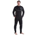
Drysuit undergarments (or undersuits) are worn beneath the dry suit to provide much of the actual insulation for the scuba diver and have a large impact on the enjoyment of a dive.
Undersuits are used for providing additional warmth when diving, traditionally under a drysuit but some are now ideal for use under a wetsuit as well. Undergarments are available in a wide range of styles, thickness grades and materials, spanning from the thinnest (e.g. Northern Diver Thermalskin) up to the much thicker and more thermally insulating (e.g. Northern Diver Metalux Arctic).
For cold-water use, especially diving under ice sheets, the user will usually wear a thick undersuit in a membrane drysuit. The thickness of undersuits varies and can be chosen by the wearer according to the water temperature. Thinsulate or Fleece (e.g. Northern Diver Arctic Base) is one of the preferred fabrics for undersuits. More recently, aerogel material is being added to conventional undergarments to increase the insulating properties of those garments.
Neoprene drysuits are made from a foam-rubber sheet containing tiny air bubbles, which provide insulation by themselves, and can eliminate the need for an undersuit, or greatly reduce the thickness needed for the under fabric. A neoprene wetsuit can also be worn under a membrane drysuit for extra protection against condensation and leaks.
Francis Henty
![]() Wreck Dive |
Wreck Dive | ![]() Shore access
Shore access
![]()
![]()
![]()
![]()
![]()
Iron Steam Dredge | Max Depth: 4 m (13 ft)
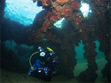
The Francis Henty shipwreck lies in 3 to 4 metres of water near the north-western end of the rocky Sandringham Pier Breakwater. Part of the old hulk, now covered in weed, mussels and sea squirts, is exposed at low water.
Diving and Snorkelling the Francis Henty Shipwreck
The are deck beams still in place, plus some internal bulkhead uprights still intact. Along the starboard side of the ship, some fallen shell plating can be observed. The port side is covered by breakwater rocks. Turbine rotor near stern.
Francis Henty Shipwreck History — Built in 1889
The Francis Henty was built in 1889, by William Simons and Co. in Renfrew, Scotland. Initially a dredge, the Frances Henty was later used as a cable layer. She was 146.5 ft (45 m) in length, with a beam of 32.2 ft (9.81 m), and a depth of 11.3 ft (3.44 m).
Francis Henty Sinking — Scuttled 1949
The Francis Henty was scuttled to form a breakwater by the harbour authority in 1949.
See also, Australian National Shipwreck Database: Francis Henty, and
Heritage Council Victoria: Francis Henty.
Heritage Warning: Any shipwreck or shipwreck relic that is 75 years or older is protected by legislation. Other items of maritime heritage 75 years or older are also protected by legislation. Activities such as digging for bottles, coins or other artefacts that involve the disturbance of archaeological sites may be in breach of the legislation, and penalties may apply. The legislation requires the mandatory reporting to Heritage Victoria as soon as practicable of any archaeological site that is identified. See Maritime heritage. Anyone with information about looting or stolen artefacts should call Heritage Victoria on (03) 7022 6390, or send an email to heritage.victoria@delwp.vic.gov.au.
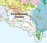
Traditional Owners — This dive site is in the traditional Country of the Boon Wurrung / Bunurong people of the Kulin Nation. This truly ancient Country includes parts of Port Phillip, from the Werribee River in the north-west, down to Wilson's Promontory in the south-east, including the Mornington Peninsula, French Island and Phillip Island, plus Western Port. We wish to acknowledge the Boon Wurrung as Traditional Owners. We pay respect to their Ancestors and their Elders, past, present and emerging. We acknowledge Bunjil the Creator Spirit of this beautiful land, who travels as an eagle, and Waarn, who protects the waterways and travels as a crow, and thank them for continuing to watch over this Country today and beyond.
Francis Henty Location Map
Latitude: 37° 56.529′ S (37.942158° S / 37° 56′ 31.77″ S)
Longitude: 144° 59.540′ E (144.992334° E / 144° 59′ 32.4″ E)
Datum: WGS84 |
Google Map
| Get directions
Added: 2012-07-22 09:00:00 GMT, Last updated: 2022-04-27 08:50:45 GMT
Source: Google Earth
Nearest Neighbour: J7 Submarine, 242 m, bearing 122°, ESE
Cable layer, steamer hulk.
Built: Renfrew, Scotland, 1889.
Sunk: 1949.
Sandringham, Bayside, Port Phillip.
Depth: 3 to 4 m.
[ Top ]
DISCLAIMER: No claim is made by The Scuba Doctor as to the accuracy of the dive site coordinates listed here. Should anyone decide to use these GPS marks to locate and dive on a site, they do so entirely at their own risk. Always verify against other sources.
The marks come from numerous sources including commercial operators, independent dive clubs, reference works, and active divers. Some are known to be accurate, while others may not be. Some GPS marks may even have come from maps using the AGD66 datum, and thus may need be converted to the WGS84 datum. To distinguish between the possible accuracy of the dive site marks, we've tried to give each mark a source of GPS, Google Earth, or unknown.
Copyright © 2005-2022 by The Scuba Doctor Australia, ABN 88 116 755 170. All rights reserved.
tel. +61 3 5985 1700 :: email. diveshop@scubadoctor.com.au :: Web site by it'sTechnical 2022









![Halcyon Infinity 30lb System [SS Small Backplate] Halcyon Infinity 30lb System [SS Small Backplate]](/diveshop/images/halcyon/Halcyon-Evolve-Wing.jpg)


