Navigation
George Kermode
![]() Wreck Dive |
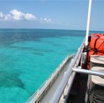
Wreck Dive | ![]() Boat access
Boat access
![]()
![]()
![]()
Twin Screw Steam Bucket Dredge | Max Depth: 20 m (66 ft)
Level: Open Water and beyond.
The George Kermode is a scuttled steam bucket dredge boat sitting offshore from the Phillip Island Grand Prix Circuit on the southern side of Phillip Island. A fantastic wreck dive, she is fairly well intact with lots of penetration opportunities.
Diving the George Kermode Shipwreck
Given the location of the George Kermode off Phillip Island in Bass Strait, and the long run from launching at the Newhaven boat ramp or Flinders Pier, it usually requires a few days of strong northerly winds to flatten the swell out at the dive site.
The George Kermode shipwreck lies roughly 1.4 km SSE from the centre of Cunningham Bay (Siberia Corner of Phillip Island Circuit) upside-down in 20 m (66 ft) of water, coming up off the bottom to nearly 12 m (39 ft) in some places. It's a relatively shallow dive compared to most of the other wrecks accessible outside of Port Phillip so you get plenty of time to explore.
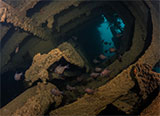
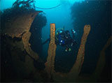
There are plenty of fish as well as interesting bits of industrial hardware like the enormous cog gear wheels. The George Kermode wreck is broken up in the middle, with big dredge buckets lying out on the sand in several locations. With the bottom of the hull pointing towards the sky, there is plenty to enjoy as you swim through the boilers. There are lots of nooks and crannies to look in, and it can be tricky to work out which bit of the wreck is which. For those suitably qualified, the George Kermode offers some excellent penetration. Accessible points of interest include two massive boilers, the chain lockers, and a large section of the bow.
The reef around the wreck site can also be an interesting dive.
See WillyWeather (Cunningham Bay) as a guide for the tide times and the height of the tide.
George Kermode - Phillip Island wreck dive | © Andrew Quested
George Kermode Shipwreck History — Built in 1914
Built in 1914 by Fleming and Ferguson in Paisley, Scotland as Sir William Matthews for the Ceylon Government, she was a twin screwed steam bucket dredge. The overall length of the vessel was approximately 230.104 ft (70 m), beam 44.10 ft (13 m) and draught 17.10 ft (5.21 m) giving a displacement weight of 803 t (885 s-ton).
She was purchased from the Western Australian Government by the Melbourne Harbour Trust on 10 October 1941. After an extensive overhaul, the vessel was renamed the George Kermode and commenced operation in Victorian waters on 22 June 1942. The vessel was hired out to the Port of Burnie in 1945-46 but continued in the ownership of the Melbourne Harbour Trust.
George Kermode Sinking — Scuttled 1 April 1976
The George Kermode was scuttled by the Department of Conservation, Forests and Land on Thursday 1 April 1976 as part of an artificial reef programme. This program resulted in a number of artificial reefs being established in Port Phillip, including one off Carrum containing the wooden steamer Uralba.
See also, Heritage Council Victoria: TSS George Kermode.
Finding the George Kermode Shipwreck
Over the years we've been provided with different GPS marks for the George Kermode shipwreck. The GPS marks we know of in circulation for the George Kermode are:
- Scuba Doctor:
Latitude: 38° 31.230′ S (38.5205° S / 38° 31′ 13.8″ S)
Longitude: 145° 14.687′ E (145.244783° E / 145° 14′ 41.22″ E) - Peter:
Latitude: 38° 31.212′ S (38.5202° S / 38° 31′ 12.72″ S)
Longitude: 145° 14.712′ E (145.2452° E / 145° 14′ 42.72″ E)
49 m, bearing 47°, NE
The GPS mark we're using seems to be on the southern side of the wreck and near its western end. It might be a good place to anchor close by the wreck.
The GPS mark from "Peter" is pretty much amidships over the highest point of the shipwreck. It might be a good "first finder" mark but not so good to drop the pick on in case it falls inside.
The wreck alignment is about 60° (ENE), or 240° (WSW) going the other way. This may be of assistance to any first timers heading down to dive the George Kermode. You can launch your dive boat both from Flinders and from Newhaven (Phillip Island) boat ramps. The distances are similar at around 22 km one-way, but the more weather exposed route from Flinders requires careful consideration if there is any chance of a west or south-westerly springing up for the homeward run.
Heritage Warning: Any shipwreck or shipwreck relic that is 75 years or older is protected by legislation. Other items of maritime heritage 75 years or older are also protected by legislation. Activities such as digging for bottles, coins or other artefacts that involve the disturbance of archaeological sites may be in breach of the legislation, and penalties may apply. The legislation requires the mandatory reporting to Heritage Victoria as soon as practicable of any archaeological site that is identified. See Maritime heritage. Anyone with information about looting or stolen artefacts should call Heritage Victoria on (03) 7022 6390, or send an email to heritage.victoria@delwp.vic.gov.au.
Bass Strait Warning: Always keep an eye on sea conditions throughout any shore or boat dive in Bass Strait on Victoria's coastline. Please read the warnings on the web page diving-in-bass-strait before diving or snorkelling this site.
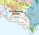
Traditional Owners — This dive site is in the traditional Country of the Boon Wurrung / Bunurong people of the Kulin Nation. This truly ancient Country includes parts of Port Phillip, from the Werribee River in the north-west, down to Wilson's Promontory in the south-east, including the Mornington Peninsula, French Island and Phillip Island, plus Western Port. We wish to acknowledge the Boon Wurrung as Traditional Owners. We pay respect to their Ancestors and their Elders, past, present and emerging. We acknowledge Bunjil the Creator Spirit of this beautiful land, who travels as an eagle, and Waarn, who protects the waterways and travels as a crow, and thank them for continuing to watch over this Country today and beyond.
George Kermode Location Map
Latitude: 38° 31.230′ S (38.5205° S / 38° 31′ 13.8″ S)
Longitude: 145° 14.687′ E (145.244783° E / 145° 14′ 41.22″ E)
Datum: WGS84 |
Google Map
Added: 2012-07-22 09:00:00 GMT, Last updated: 2022-04-29 14:05:14 GMT
Source: GPS (verified)
Nearest Neighbour: Cunningham Bay, 1,442 m, bearing 342°, NNW
Twin Screw Steam Bucket Dredge.
Built: Scotland, 1914.
Sunk: 1 April 1976.
Phillip Island, Bass Strait.
Depth: 12 to 20 m.
[ Top ]
DISCLAIMER: No claim is made by The Scuba Doctor as to the accuracy of the dive site coordinates listed here. Should anyone decide to use these GPS marks to locate and dive on a site, they do so entirely at their own risk. Always verify against other sources.
The marks come from numerous sources including commercial operators, independent dive clubs, reference works, and active divers. Some are known to be accurate, while others may not be. Some GPS marks may even have come from maps using the AGD66 datum, and thus may need be converted to the WGS84 datum. To distinguish between the possible accuracy of the dive site marks, we've tried to give each mark a source of GPS, Google Earth, or unknown.
Copyright © 2005-2022 by The Scuba Doctor Australia, ABN 88 116 755 170. All rights reserved.
tel. +61 3 5985 1700 :: email. diveshop@scubadoctor.com.au :: Web site by it'sTechnical 2022





![Halcyon Infinity 30lb System [SS Small Backplate] Halcyon Infinity 30lb System [SS Small Backplate]](/diveshop/images/halcyon/Halcyon-Evolve-Wing.jpg)


