Navigation
There's so many wonderful things to learn about our underwater wonderland - from marine life and fish species, from wrecks dives and reef dive sites, from factual science to weird unknowns and beyond. Delve into the wide range of underwater topics in the books below and quench your thirst for knowledge with a good old fashioned read.
La Bella
![]() Wreck Dive |
Wreck Dive | ![]() Boat access
Boat access
![]()
![]()
![]()
Three-Masted Steel Barquentine | Max Depth: 13 m (43 ft)
Level: Open Water and beyond.
The La Bella shipwreck is a boat dive site which lies in Lady Bay, offshore from Warrnambool on Victoria's Shipwreck Coast. The La Bella is typical of the type of medium-sized iron/steel sailing vessels sailing in an age where sail was being rapidly superseded by steam.
The sinking of La Bella triggered one of the most heroic rescues in Victoria's shipwreck history. La Bella was at the end of a rough and tedious 37 day voyage, bringing timber from Lyttleton, New Zealand to Warrnambool. Rough conditions forced La Bella to run aground on a reef at Lady Bay only a few 100 yards from the Warrnambool breakwater. The brave actions of a young fisherman and a volunteer lifeboat crew managed to save the lives of five of the 12 crew.
In fact Warrnambool did not hold happy memories for La Bella. On its only other visit a year prior to wrecking, it was anchored at the mouth of the Hopkins River in rough weather. The captain went shore to find a tow. When he returned he found his crew drunk and unwilling to take up their posts. Even though the ship was dragging its anchors and in a precarious position.
Diving the La Bella Shipwreck
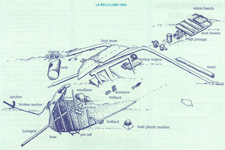
The La Bella now lies on its port side, in sheltered water inside the reef she struck, with its bow facing south-west, in 13 m (43 ft) of water, 300 m (984 ft) south-east of the end of the Warrnambool breakwater. Divers found the wreck site in 1982. The reef the La Bella struck now bears its name.
Although heavily covered in thick kelp and weed growth, the La Bella is a spectacular dive.
The five-metre high ship's bow section lies on its port side and is relatively intact. Divers swimming around the bow will be able to see the bowsprit, several anchors, an anchor chain, catheads, winches and hawsepipes.
Part of the stern has drifted north-easterly towards the mouth of the Hopkins River.
In the midships region divers should see a donkey engine, parts of the rigging, decking frames, a deck winch, bilge pumps and bollards.
Over time the stem has broken up and has now disappeared. An information plinth lies in the midships region off the port side of the ship. It was placed there by the staff of the National Safety Council and the Flagstaff Hill Maritime Museum, sponsored by Warrnambool Textiles.
Location: Warrnambool, Victoria 3280
It's far too dangerous to attempt to dive this shipwreck as a shore dive, even in ideal conditions.
Ideal Conditions: Very calm condition with minimal swell are required to dive this site. Light offshore north-westerly to north easterly winds are okay. Moderate to strong easterly to westerly winds are not suitable. The current is usually minimal. See WillyWeather (Lady Bay) as a guide for the tide times and the height of the tide.
Boat Launching: The La Bella shipwreck is reached by boat from the nearby Warrnambool (Lady Bay) boat ramp.
{{southern-ocean-warning}} {{sally-watson}}
Shipwrecks of South-west Victoria | Source: Flagstaff Hill Maritime Museum
La Bella Shipwreck History — Built in 1893
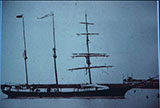
The La Bella was a three-masted steel barquentine of 406 tons, built in 1893 by Johan Smith Jernskibsbyggeri, in Tvedestrand, Norway. The vessel was 144 ft (44 m) in length, with a beam of 27.3 ft (8.32 m), and a depth of 12.5 ft (3.81 m).
At the time of its demise the La Bella was owned by David Turnbull and registered in Lyttleton, New Zealand. She was engaged in the intercolonial timber trade between New Zealand and Port Phillip from 1902.
La Bella Sinking — 10 November 1905
On 5 October 1905, the La Bella left Kiapura, New Zealand, bound for Warrnambool with a cargo of timber. Because of bad weather en route, she sheltered at Burnie on Tasmania's North West coast.
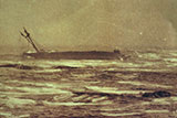
On 10 November 1905 the La Bella approached Warrnambool in an evening mist and heavy south-west sea. Captain Mylius ordered the helmsman to steer for the light. As the ship came round, a tremendous sea struck her on the port quarter, causing her to broach broadside in a north-westerly direction into breakers. The helm was brought round twice more, but each time heavy seas broke over her, the third time throwing the La Bella onto a submerged reef.
The Warrnambool Harbour Master, Captain Roe (who lived in the Harbourmaster's House opposite Flagstaff Hill) and four lifesavers rowed out in a whaleboat to the distressed ship. The 'old' Warrnambool lifeboat also attended to the ship, however, volunteer fishermen and other volunteers were called for to man the lifeboat, as most of the lifeboat crew were away at Port McDonnell.
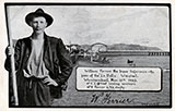
The whaleboat found it impossible to get near the La Bella because of the surging breakers. When the lifeboat reached the site, her crew attempted to rescue the crew of the La Bella, who were lashed to the port rails. Three of these men were eventually rescued by the lifeboat. Two others, including Captain Mylius, were saved by a young fisherman, William Ferrier, who sculled out twice in his small dinghy.
The rest of the La Bella crew of twelve fell victims to the conditions. Three were washed overboard at about 11 p.m., two more at about 2 a.m. and two were drowned when attempting to reach the lifeboat. Shortly after the last man was rescued, the La Bella was lifted by a huge wave, crashing back down on the reef and partly breaking.
An inquiry into the disaster found Captain Mylius at fault for sailing into the Bay without obtaining the services of a pilot. His Master Certificate was suspended for twelve months. A short time later he was charged with manslaughter of one of the crew who died when La Bella was wrecked. Although Captain Mylius was found not guilty, the tragic sequence of events, adverse publicity and damage to his career took its toll on his health. He died of a heart attack six months after the wreck at the age of thirty-seven.
In recognition of his bravery, William Ferrier received telegrams from the Governor-General and Governor of Victoria and a cheque for £20 from the Premier of Victoria. He was also awarded the Royal Humane Society Silver Medal, and clothing.
See also, west-coast-shipwreck-trail,
Heritage Council Victoria: La Bella,
Australian National Shipwreck Database: La Bella, and
Dive Information Sheet: La Bella (1883-1905).
This vessel is one of the many historic shipwrecks included in Victoria's shipwreck-discovery-trail. Qualified divers can explore the wrecks of old wooden clippers, iron steamships and cargo and passenger vessels located along the coast and in Port Phillip. Some of these wreck dives are suitable for beginners, even snorkellers, while other wrecks require the skills and experience of advanced divers.
Heritage Warning: Any shipwreck or shipwreck relic that is 75 years or older is protected by legislation. Other items of maritime heritage 75 years or older are also protected by legislation. Activities such as digging for bottles, coins or other artefacts that involve the disturbance of archaeological sites may be in breach of the legislation, and penalties may apply. The legislation requires the mandatory reporting to Heritage Victoria as soon as practicable of any archaeological site that is identified. See Maritime heritage. Anyone with information about looting or stolen artefacts should call Heritage Victoria on (03) 7022 6390, or send an email to heritage.victoria@delwp.vic.gov.au.
Finding the La Bella Shipwreck
Over the years we've been provided with different GPS marks for the La Bella. The GPS marks we know of in circulation for the La Bella are:
- GPS (verified):
Latitude: 38° 24.254′ S (38.404231520628° S / 38° 24′ 15.23″ S)
Longitude: 142° 28.889′ E (142.48148342822° E / 142° 28′ 53.34″ E) - Dive Victoria:
Latitude: 38° 24.220′ S (38.403667° S / 38° 24′ 13.2″ S)
Longitude: 142° 29.140′ E (142.485667° E / 142° 29′ 8.4″ E)
370 m, bearing 80°, E
Traditional Owners — This dive site is in the traditional Country of the Eastern Maar people of south-western Victoria between the Shaw and Eumerella Rivers and from Yambuk in the south to beyond Lake Linlithgow in the north. This truly ancient Country extends as far north as Ararat and encompasses the coastal townships of Port Fairy in the west, Warrnambool, Peterborough, Port Campbell, Apollo Bay, Lorne, and Airies Inlet in the east, including the Great Ocean Road area. It also stretches 100 metres out to sea from low tide and therefore includes the iconic Twelve Apostles. "Eastern Maar" is a name adopted by the people who identify as Maar, Eastern Gunditjmara, Tjap Wurrung, Peek Whurrong, Kirrae Whurrung, Kuurn Kopan Noot and/or Yarro waetch (Tooram Tribe) amongst others. We wish to acknowledge the Eastern Maar as Traditional Owners. We pay respect to their Ancestors and their Elders, past, present and emerging.
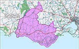
La Bella Location Map
Latitude: 38° 24.254′ S (38.404232° S / 38° 24′ 15.24″ S)
Longitude: 142° 28.889′ E (142.481483° E / 142° 28′ 53.34″ E)
Datum: WGS84 |
Google Map
Added: 2012-07-22 09:00:00 GMT, Last updated: 2022-05-24 12:47:38 GMT
Source: GPS (verified)
Nearest Neighbour: Old Aquarium, 501 m, bearing 276°, W
Three-Masted Steel Barquentine Ship.
Built: Norway, 1893.
Sunk: 10 November 1905.
Warrnambool, Shipwreck Coast.
Depth: 13 m.
[ Top ]
DISCLAIMER: No claim is made by The Scuba Doctor as to the accuracy of the dive site coordinates listed here. Should anyone decide to use these GPS marks to locate and dive on a site, they do so entirely at their own risk. Always verify against other sources.
The marks come from numerous sources including commercial operators, independent dive clubs, reference works, and active divers. Some are known to be accurate, while others may not be. Some GPS marks may even have come from maps using the AGD66 datum, and thus may need be converted to the WGS84 datum. To distinguish between the possible accuracy of the dive site marks, we've tried to give each mark a source of GPS, Google Earth, or unknown.
Copyright © 2005-2022 by The Scuba Doctor Australia, ABN 88 116 755 170. All rights reserved.
tel. +61 3 5985 1700 :: email. diveshop@scubadoctor.com.au :: Web site by it'sTechnical 2022






![Halcyon Infinity 30lb System [SS Small Backplate] Halcyon Infinity 30lb System [SS Small Backplate]](/diveshop/images/halcyon/Halcyon-Evolve-Wing.jpg)


