Navigation
Marie Gabrielle
![]() Wreck Dive |
Wreck Dive | ![]() Boat access
Boat access
![]()
![]()
![]()
Three-Masted Wooden Barque | Max Depth: 3 m (9.84 ft)
The Marie Gabrielle shipwreck lies near Moonlight Head, offshore from Wreck Beach to the west of Apollo Bay on Victoria's Shipwreck Coast. Whilst it is believed that the Captain and all crew made it off the wreck, it was then reported that four south sea islanders were missing from the crew. Two bodies were later found in a gully not far from the wreck site. The others were never found.
Diving the Marie Gabrielle
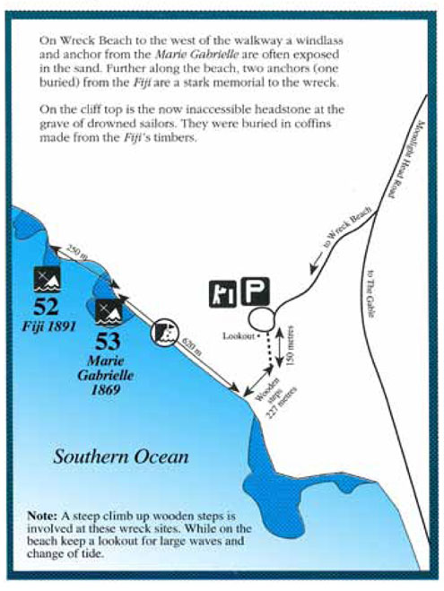
Two Admiralty type iron anchors and a winch/windlass from the wreck of Marie Gabrielle can be seen at low tide. The windlass is a composite wood and iron type, with a square section iron bar through the centre. The construction is clearly evident as wind and waves have eroded most of the wood away.
The Marie Gabrielle shipwreck lies some 70 m (230 ft) offshore from Wreck Beach, near Moonlight Head on a bearing of 210 degrees directly seaward off the Marie Gabrielle anchors on the beach. The wreck's remains lie in a shallow gully some 3 metres deep and 20 metres off scattering towards the beach. A chain mound is located in the gully and the anchor chain runs from this across the reef, and by report continues all the way to the anchors on the beach.
Three or four iron knees lie in the gully along with two hexagonal mast hoops and pipe. Timber fragments are located under the reef ledge to the right and left of the site. The Marie Gabrielle lies to the east of the Fiji shipwreck site.
The site is subject to heavy breakers which break heavily to the right and left of the gully in a very dangerous and exposed position. It's subject to heavy swells and surge conditions and is best visited by divers during calm northerlies when the swell is minimal. See WillyWeather (Wreck Beach) as a guide for the tide times and the height of the tide.
{{southern-ocean-warning}}Marie Gabrielle History
The Marie Gabrielle was a three-masted wooden barque of 258 tons, built in 1864 by Boju and Clairgeau Harland and Wolfe in Nantes, France. It was launched on 21 September 1875 and completed on 29 October 1875. The dimensions of the vessel are unknown.
Marie Gabrielle Sinking
The barque Marie Gabrielle left Foochow, China on 8 September 1869 bound for Melbourne with a crew of eleven under the command of Captain Blanchard. The cargo was 2641 half-chests, 3071 boxes of tea consigned to Robert Towns and Co, plus 103 chests, 1091 half-chests, 488 boxes of tea consigned to H Langdon and Co.
The Marie Gabrielle was driven ashore at Wreck Beach at Moonlight Head at 1 a.m. in the morning on 25 November 1869. At daylight, as seas calmed, the crew got ashore safely via the ships boat and a small party set off to walk around the coast to Cape Otway and the lighthouse visible away to the east. Four of the crew waited at the wreck.
By the third day the main party were without water and cut badly by the dense scrub. The next day they saw the lighthouse tower as close and called for help. Children of the lightkeepers were playing down on the beach below the lighthouse and mistaking the cries of the crew (in French naturally) and alarmed by their appearance ran away and told the lighthouse superintendent Henry Ford.
A rescue party set out for Moonlight Head and brought the remaining crew members to the lighthouse. The survivors stayed at Cape Otway and at the Aire River Station, established by the Roadknight family in the 1840s, for over a month and were conveyed to Melbourne when the lighthouse supply vessel made its next (twice yearly) supply trip.
A report in The Argus, Thursday 20 Oct 1870, on page 6, titled "THE WRECK OF THE MARIE GABRIELLE" lays out additional information.
It will be within the recollection of our readers that when the French vessel Marie Gabrielle was wrecked near Moonlight Head last year, four South Sea Island natives were cast ashore, and deserted by the crew of that ill-fated ship. In the issue of the Guardian of the 21st January last we told the story of the wreck, and the mysterious disappearance of these unfortunate men, relating how that when the vessel came ashore, the crew started for Cape Otway, and succeeded, after four days' painful travel, in reaching the lighthouse, from whence they were forwarded to Melbourne. Rumours, however, obtained circulation with reference to these men, and the fact of their having come ashore seemed to be generally known to most of those who subsequently visited the scene of the wreck.
In the month of February, or about two months after the occurrence of the wreck, the police authorities instituted a search, and a party of four, led by Senior-constable Swale, traversed the scrub and coast from the wreck to Cape Otway, but without discovering any traces of the missing islanders. The general impression then seemed to be that either they had never come ashore, or they had lost their lives in an attempt to escape by sea.
So far as two of the unfortunates are concerned, their fate seems at length to have been discovered. We yesterday received from Mr. J. W. Oliver, son of Mr. Donald Oliver, who owns some country on the Gellibrand, the following letter, in which he describes the discovery of the bodies:
"As I have discovered the remains of two of the South Sea Islanders that were lost from the wreck of the Marie Gabrielle, I take the earliest opportunity of informing you that you may make it public in your journal. The two bodies lie on the side of a gully, about a mile from the wreck, in the direction of Moonlight Head. They have all the appearance of having been dead since the time of the wreck."
Some 20-years later on 6 September 1891, the Fiji was wrecked on the same rock, since known as Wreck Reef.
See also, west-coast-shipwreck-trail,
Heritage Council Victoria: Marie Gabrielle, and
Australian National Shipwreck Database: Marie Gabrielle, and
Shipwrecks of Apollo Bay and Surrounds.
This vessel is one of the many historic shipwrecks included in Victoria's shipwreck-discovery-trail. Qualified divers can explore the wrecks of old wooden clippers, iron steamships and cargo and passenger vessels located along the coast and in Port Phillip. Some of these wreck dives are suitable for beginners, even snorkellers, while other wrecks require the skills and experience of advanced divers.
Heritage Warning: Any shipwreck or shipwreck relic that is 75 years or older is protected by legislation. Other items of maritime heritage 75 years or older are also protected by legislation. Activities such as digging for bottles, coins or other artefacts that involve the disturbance of archaeological sites may be in breach of the legislation, and penalties may apply. The legislation requires the mandatory reporting to Heritage Victoria as soon as practicable of any archaeological site that is identified. See Maritime heritage. Anyone with information about looting or stolen artefacts should call Heritage Victoria on (03) 7022 6390, or send an email to heritage.victoria@delwp.vic.gov.au.
Traditional Owners — This dive site is in the traditional Country of the Eastern Maar people of south-western Victoria between the Shaw and Eumerella Rivers and from Yambuk in the south to beyond Lake Linlithgow in the north. This truly ancient Country extends as far north as Ararat and encompasses the coastal townships of Port Fairy in the west, Warrnambool, Peterborough, Port Campbell, Apollo Bay, Lorne, and Airies Inlet in the east, including the Great Ocean Road area. It also stretches 100 metres out to sea from low tide and therefore includes the iconic Twelve Apostles. "Eastern Maar" is a name adopted by the people who identify as Maar, Eastern Gunditjmara, Tjap Wurrung, Peek Whurrong, Kirrae Whurrung, Kuurn Kopan Noot and/or Yarro waetch (Tooram Tribe) amongst others. We wish to acknowledge the Eastern Maar as Traditional Owners. We pay respect to their Ancestors and their Elders, past, present and emerging.
Marie Gabrielle Location Map
Latitude: 38° 45.246′ S (38.7541° S / 38° 45′ 14.76″ S)
Longitude: 143° 12.490′ E (143.208161° E / 143° 12′ 29.38″ E)
Datum: WGS84 |
Google Map
Added: 2021-08-16 09:07:55 GMT, Last updated: 2022-05-23 20:19:58 GMT
Source: Google Earth
Nearest Neighbour: Fiji, 327 m, bearing 297°, WNW
Three-masted wooden barque.
Built: Nantes, France, 1864.
Sunk: 25 November 1869.
Wreck Beach, Moonlight Head, Shipwreck Coast.
Depth: 3 m.
[ Top ]
DISCLAIMER: No claim is made by The Scuba Doctor as to the accuracy of the dive site coordinates listed here. Should anyone decide to use these GPS marks to locate and dive on a site, they do so entirely at their own risk. Always verify against other sources.
The marks come from numerous sources including commercial operators, independent dive clubs, reference works, and active divers. Some are known to be accurate, while others may not be. Some GPS marks may even have come from maps using the AGD66 datum, and thus may need be converted to the WGS84 datum. To distinguish between the possible accuracy of the dive site marks, we've tried to give each mark a source of GPS, Google Earth, or unknown.
Copyright © 2005-2022 by The Scuba Doctor Australia, ABN 88 116 755 170. All rights reserved.
tel. +61 3 5985 1700 :: email. diveshop@scubadoctor.com.au :: Web site by it'sTechnical 2022








![Halcyon Infinity 30lb System [SS Small Backplate] Halcyon Infinity 30lb System [SS Small Backplate]](/diveshop/images/halcyon/Halcyon-Evolve-Wing.jpg)


