Navigation
Our selection of the Top 10 Best scuba diving masks available will enable you to see clearly underwater in comfort. Of course all of these masks are also suitable for snorkelling.
Quarantine Station
![]() Shore Dive |
Shore Dive | ![]() Shore access
Shore access
![]()
![]()
![]()
![]()
![]()
Depth: 2 m (6.56 ft) to 18 m (59 ft)
Level: Open Water and beyond.
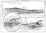
The Quarantine Station is located in Ticonderoga Bay near Portsea, not far from the tip of Point Nepean, on the eastern site of Port Phillip. It operated from the 1850s to about the 1950s and is a reminder of an era where many thousands of people were put into isolation on arrival in Melbourne on ships due to risks from infectious diseases.
There are the ruins of a jetty used to bring people ashore from the ships that would be at anchor offshore. There are lots of bottles, plates, coins and other artefacts that were discarded overboard from the ships. Storms cause the sands to cover and uncover these artefacts.
On a dive over the mostly sandy bottom out from the Quarantine Station you can come across these artefacts. Look, but don't touch as they're protected. Best done as a slack water dive.
See WillyWeather (Portsea Pier) as a guide for the tide times and the height of the tide.
Quarantine Station History
In the early 1850s colonial authorities were searching for a replacement site for Melbourne's Point Ormond Quarantine Station. Point Nepean, remote and almost uninhabited, was deemed ideal.
Five large accommodation blocks were constructed in 1858-59, one for sick passengers and four for those unaffected but quarantined nonetheless. The oldest building on the site is a shepherds hut, dating back to 1845.
Heritage Warning: Any shipwreck or shipwreck relic that is 75 years or older is protected by legislation. Other items of maritime heritage 75 years or older are also protected by legislation. Activities such as digging for bottles, coins or other artefacts that involve the disturbance of archaeological sites may be in breach of the legislation, and penalties may apply. The legislation requires the mandatory reporting to Heritage Victoria as soon as practicable of any archaeological site that is identified. See Maritime heritage. Anyone with information about looting or stolen artefacts should call Heritage Victoria on (03) 7022 6390, or send an email to heritage.victoria@delwp.vic.gov.au.
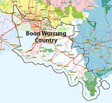
Traditional Owners — This dive site is in the traditional Country of the Boon Wurrung / Bunurong people of the Kulin Nation. This truly ancient Country includes parts of Port Phillip, from the Werribee River in the north-west, down to Wilson's Promontory in the south-east, including the Mornington Peninsula, French Island and Phillip Island, plus Western Port. We wish to acknowledge the Boon Wurrung as Traditional Owners. We pay respect to their Ancestors and their Elders, past, present and emerging. We acknowledge Bunjil the Creator Spirit of this beautiful land, who travels as an eagle, and Waarn, who protects the waterways and travels as a crow, and thank them for continuing to watch over this Country today and beyond.
Quarantine Station Location Map
Latitude: 38° 18.712′ S (38.311874° S / 38° 18′ 42.75″ S)
Longitude: 144° 41.715′ E (144.695252° E / 144° 41′ 42.91″ E)
Datum: WGS84 |
Google Map
| Get directions
Added: 2012-07-22 09:00:00 GMT, Last updated: 2022-04-29 13:39:14 GMT
Source: Google Earth
Nearest Neighbour: Quarantine Station Anchor, 574 m, bearing 14°, NNE
Portsea, Mornington Peninsula, Port Phillip.
Depth: 2 to 18 m.
Dive only on: SWF, SWE.
[ Top ]
DISCLAIMER: No claim is made by The Scuba Doctor as to the accuracy of the dive site coordinates listed here. Should anyone decide to use these GPS marks to locate and dive on a site, they do so entirely at their own risk. Always verify against other sources.
The marks come from numerous sources including commercial operators, independent dive clubs, reference works, and active divers. Some are known to be accurate, while others may not be. Some GPS marks may even have come from maps using the AGD66 datum, and thus may need be converted to the WGS84 datum. To distinguish between the possible accuracy of the dive site marks, we've tried to give each mark a source of GPS, Google Earth, or unknown.
Copyright © 2005-2022 by The Scuba Doctor Australia, ABN 88 116 755 170. All rights reserved.
tel. +61 3 5985 1700 :: email. diveshop@scubadoctor.com.au :: Web site by it'sTechnical 2022








![Halcyon Infinity 30lb System [SS Small Backplate] Halcyon Infinity 30lb System [SS Small Backplate]](/diveshop/images/halcyon/Halcyon-Evolve-Wing.jpg)


