Navigation
SS Barwon
![]() Wreck Dive |
Wreck Dive | ![]() Boat access
Boat access
![]()
![]()
Three-Masted Schooner Rigged Iron Screw Steamer | Max Depth: 5 m (16 ft)
Level: Open Water and beyond.
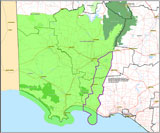
The SS Barwon shipwreck lies offshore at Cape Bridgewater, near Fisherman Cove, on Victoria's Discovery Coast. The vessel struck a rock and foundered several hundred metres off the beach between Cape Nelson and Cape Bridgewater.
Diving the SS Barwon Shipwreck
The SS Barwon dive site is near Fisherman Cove on the eastern side of Cape Bridgewater. Fisherman Cove is, as the name suggests, an area of quieter water in the energetic Bridgewater Bay. The cove faces east and is well protected by Cape Bridgewater, with waves averaging less than 1 metre.
Location: Cape Bridgewater, Victoria 3305
Ideal Conditions: The dive site is very weather dependant and best dived in good conditions with a low swell and light offshore westerly winds. See WillyWeather (Cape Bridgewater) as a guide for the tide times and the height of the tide.
Access is by boat from the Cape Bridgewater Boat Ramp, or further away from the Portland Harbour, Lee Breakwater Road North Ramp or the Portland Harbour, Lee Breakwater Road South Ramp.
{{southern-ocean-warning}}SS Barwon Shipwreck History — Built in 1863
The SS Barwon was a three-masted, schooner rigged, iron screw steamer of 406 gross tons built in 1863 by R. Little & Co at Greenock, Scotland. The vessel had an overall length of approximately 172.3 ft (53 m), beam 21.6 ft (6.58 m) and draught 14 ft (4.27 m).
The vessel had been previously stranded at Queenscliff and was ashore for 6 months prior to it being refloated.
SS Barwon Sinking — 3 April 1871
On the morning of Monday 3 April 1871, while steaming between Adelaide and Sydney with flour, crew and 28 passengers, the SS Barwon struck the reef Wadmores Rock in foggy conditions some 200 metres offshore Cape Bridgewater and commenced to sink directly below McKinley's cottage. In a very calm sea, she slid off the rock and into deep water. The passengers took to the boats while the Captain and crew brought her round into Bridgewater Bay intending to beach her. But the vessel sank before reaching the beach.
The Marine Board of Inquiry found that Captain James C. Shoobart contributed to the loss by not ascertaining the vessel's position more carefully when off Cape Northumberland. The wreck was blamed on the Second Officer, John Nelson, who was on watch and should have called the captain and slowed down when he first noticed the fog.
See also, west-coast-shipwreck-trail,
Heritage Council Victoria: SS Barwon, and
Australian National Shipwreck Database: SS Barwon.
Heritage Warning: Any shipwreck or shipwreck relic that is 75 years or older is protected by legislation. Other items of maritime heritage 75 years or older are also protected by legislation. Activities such as digging for bottles, coins or other artefacts that involve the disturbance of archaeological sites may be in breach of the legislation, and penalties may apply. The legislation requires the mandatory reporting to Heritage Victoria as soon as practicable of any archaeological site that is identified. See Maritime heritage. Anyone with information about looting or stolen artefacts should call Heritage Victoria on (03) 7022 6390, or send an email to heritage.victoria@delwp.vic.gov.au.
Traditional Owners — This dive site is in the traditional Country of the Gunditjmara people of far south-western Victoria which continues over the state border into a small part of south-east South Australia and is bordered by the Glenelg River to the west and the Wannon River in the north. This truly ancient Country extends 100 metres out to sea from low tide and also includes Deen Maar (aka Lady Julia Percy Island) where the Gunditjmara believe the spirits of their dead travel to wait to be reborn. We wish to acknowledge the Gunditjmara as Traditional Owners. We pay respect to their Ancestors and their Elders, past, present and emerging.
SS Barwon Location Map
Latitude: 38° 22.625′ S (38.377075° S / 38° 22′ 37.47″ S)
Longitude: 141° 24.704′ E (141.411729° E / 141° 24′ 42.22″ E)
Datum: WGS84 |
Google Map
Added: 2021-06-20 11:09:48 GMT, Last updated: 2022-05-23 16:13:39 GMT
Source: GPS
Nearest Neighbour: Horseshoe Reef, 163 m, bearing 172°, S
Three-Masted Schooner Rigged Iron Screw Steamer.
Built: Greenock, Scotland, 1863.
Sunk: 3 April 1871.
Cape Bridgewater, Discovery Coast.
Depth: 5 m.
[ Top ]
DISCLAIMER: No claim is made by The Scuba Doctor as to the accuracy of the dive site coordinates listed here. Should anyone decide to use these GPS marks to locate and dive on a site, they do so entirely at their own risk. Always verify against other sources.
The marks come from numerous sources including commercial operators, independent dive clubs, reference works, and active divers. Some are known to be accurate, while others may not be. Some GPS marks may even have come from maps using the AGD66 datum, and thus may need be converted to the WGS84 datum. To distinguish between the possible accuracy of the dive site marks, we've tried to give each mark a source of GPS, Google Earth, or unknown.
Copyright © 2005-2022 by The Scuba Doctor Australia, ABN 88 116 755 170. All rights reserved.
tel. +61 3 5985 1700 :: email. diveshop@scubadoctor.com.au :: Web site by it'sTechnical 2022








![Halcyon Infinity 30lb System [SS Small Backplate] Halcyon Infinity 30lb System [SS Small Backplate]](/diveshop/images/halcyon/Halcyon-Evolve-Wing.jpg)


