Navigation
A wide range of the finest scuba diving cylinder accessories and parts are available from The Scuba Doctor dive shop.
Sandy Gully Beach
![]() Reef Dive |
Reef Dive | ![]() Shore access
Shore access
![]()
![]()
![]()
![]()
![]()
![]()
Depth: 1 m (3.28 ft) to 10 m (33 ft)
Level: Open Water and beyond.
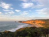
Sandy Gully Beach is a diving and snorkelling area at Aireys Inlet off the Great Ocean Road (B100) on Victoria's Surf Coast. It lies opposite Kingsley Drive facing south-south-east into Bass Strait. The beach is 500 metres long, and is bordered by 20 metre high headlands and rock platforms composed of red sandstone.
Sandy Gully Beach provides another shore access point to Eagle Nest Reef, a sandstone reef backed by 20 to 40 metre high, red bluffs. Eagle Nest Reef is a broad limestone reef running parallel to the shore for many kilometres from Split Point to the the south, and even further north of Sunnymead Beach. If you have access to a dive boat you can use the sounder to find many interesting parts of the reef and dive them.
Beginner snorkellers will be interested in the inner shallow parts of the reef. More intrepid snorkellers and divers will want to head several hundred metres out to the larger main reef structures. There is plenty of interesting reef structure to explore and lots of marine life to see. You might even get lucky and gather a feed of crayfish or abalone.
Location: Corner Eagle Rock Parade & Kingsley Drive, Aireys Inlet, Victoria 3231
Parking: Sandy Gully Beach is located at Aireys Inlet, a small coastal town on the Great Ocean Road approximately 125 km west from Melbourne and 48 km south-west of Geelong. When heading south to Aireys Inlet on the Great Ocean Road (B100), turn left onto Alice Road and then left onto Eagle Rock Parade. Just past the inersection with Kingsley Drive you'll find a parking area with a track down onto Sandy Gully Beach. Before gearing up check out the water. If you see lots of white water, head on home.
Warning: This is a highly hazardous area with deep water, rocks and reefs, with a strong rip feeder current running along the beach and a rip running out past the headland. Always go with a buddy and be extremely careful. Experienced divers and snorkellers only.
Entry/Exit: From Sandy Gully Beach opposite Kingsley Drive, Aireys Inlet.
Ideal Conditions: Only attempt to dive or snorkel here if conditions are very calm with little wind, flat seas, and no swell. The beach faces south-south-east, so is best dived with light offshore north-westerly to north-easterly winds. See WillyWeather (Sany Gully Beach) as a guide for the tide times and the height of the tide.
Bass Strait Warning: Always keep an eye on sea conditions throughout any shore or boat dive in Bass Strait on Victoria's coastline. Please read the warnings on the web page diving-in-bass-strait before diving or snorkelling this site.
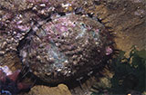
Divers have the opportunity to catch Abalone at this dive site. Remember your catch bag, legal abalone tool, current Victorian Recreational Fishing Licence, and abalone measure. Please abide by all current fishing regulations if you intend to catch abalone.
See article-catching-abalone for practical abalone hunting advice from The Scuba Doctor, plus melbourne-abalone-dives for a list of other Abalone dive sites near Melbourne.
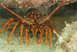
Divers have the opportunity to catch Southern Rock Lobster (aka Crayfish) at this dive site. Remember your catch bag, current Victorian Recreational Fishing Licence, rock lobster measure, and cray tags. Once you get back to the dive boat, or shore, make sure you clip the tail and tag your Crayfish as per Fisheries requirements. Please abide by all current fishing regulations if you intend to catch crays. See article-catching-crayfish for practical cray hunting advice from The Scuba Doctor, plus melbourne-cray-dives for a list of other crayfish dive sites near Melbourne. For tips on cooking your Crays, please see article-cooking-crayfish.
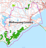
Traditional Owners — This dive site is in the traditional Country of the Wathaurong (Wadda-Warrung) people of the Kulin Nation. This truly ancient Country includes the coastline of Port Phillip, from the Werribee River in the north-east, the Bellarine Peninsula, and down to Cape Otway in the south-west. We wish to acknowledge the Wathaurong as Traditional Owners. We pay respect to their Ancestors and their Elders, past, present and emerging. We acknowledge Bunjil the Creator Spirit of this beautiful land, who travels as an eagle, and Waarn, who protects the waterways and travels as a crow, and thank them for continuing to watch over this Country today and beyond.
Sandy Gully Beach Location Map
Latitude: 38° 27.587′ S (38.459788° S / 38° 27′ 35.24″ S)
Longitude: 144° 6.754′ E (144.112563° E / 144° 6′ 45.23″ E)
Datum: WGS84 |
Google Map
| Get directions
Added: 2022-04-07 23:50:20 GMT, Last updated: 2022-04-29 12:53:00 GMT
Source: Google Earth
Nearest Neighbour: Eagle Nest Reef, 1,255 m, bearing 29°, NNE
Aireys Inlet, Surf Coast.
Depth: 1 to 10 m.
[ Top ]
DISCLAIMER: No claim is made by The Scuba Doctor as to the accuracy of the dive site coordinates listed here. Should anyone decide to use these GPS marks to locate and dive on a site, they do so entirely at their own risk. Always verify against other sources.
The marks come from numerous sources including commercial operators, independent dive clubs, reference works, and active divers. Some are known to be accurate, while others may not be. Some GPS marks may even have come from maps using the AGD66 datum, and thus may need be converted to the WGS84 datum. To distinguish between the possible accuracy of the dive site marks, we've tried to give each mark a source of GPS, Google Earth, or unknown.
Copyright © 2005-2022 by The Scuba Doctor Australia, ABN 88 116 755 170. All rights reserved.
tel. +61 3 5985 1700 :: email. diveshop@scubadoctor.com.au :: Web site by it'sTechnical 2022







![Halcyon Infinity 30lb System [SS Small Backplate] Halcyon Infinity 30lb System [SS Small Backplate]](/diveshop/images/halcyon/Halcyon-Evolve-Wing.jpg)


