Navigation
Every diver knows how important the little things are to make your dive go smoothly. The regulator accessories and parts available from The Scuba Doctor dive shop will enable you to get your regulator setup just right, and keep it that way!
Kitty Miller Bay
![]() Shore Dive |
Shore Dive | ![]() Shore access
Shore access
![]()
![]()
![]()
![]()
![]()
Depth: 2 m (6.56 ft) to 12 m (39 ft)
Kitty Miller Bay lies on the south coast of Phillip Island, between Watt Point to the east and Kennan Head to the west, looking out into Bass Strait. This secretive splash spot is directly adjacent to the world-famous Phillip Island Penguin Parade. Kitty Miller Bay is one of Phillip Island's best protected beaches. Great for snorkelling and scuba diving.
The western side of the bay is more protected, but the eastern side is more interesting if you're experienced enough to handle the sometime challenging conditions.
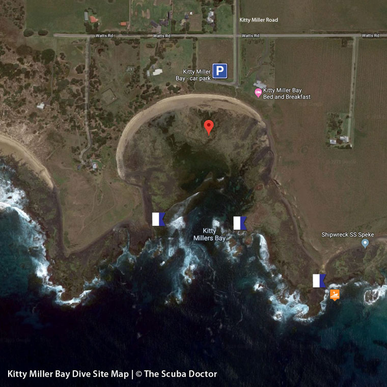
At the southern end of Kitty Miller Road, Phillip Island, it's a long walk from the car park down to the rocky beach of Kitty Miller Bay. There are entry points to the western and eastern side of the bay.
Kitty Miller Bay features 500 metres of shoreline shelter, vast rock platforms, seaweed gardens and seagrass beds, bustling with zebra fish, leather jackets, rays and Port Jackson sharks. Inexperienced snorkellers should stick to the shallows of the western corner, while those with more confidence might try the east. Take care at all times: the water might appear calm, but conditions can change quickly.
Ideal Conditions: Kitty Miller Bay is one of the safer south coast beaches, owing to the generally low waves and gently sloping central beach section. The best conditions come after several days of still weather or northerly winds. Enter on the receding tide, whenever it is safe to do so. The lower the tide, the more protected the waters, but some areas are better at mid-tide. See WillyWeather (Kitty Miller Bay) as a guide for the tide times and the height of the tide.
Location: Ventnor, Phillip Island, Victoria 3922
MELWAY Ref: Page 731 E7
Emergency Beach Location: A11
Kitty Miller Bay lies 500 metres inside the bordering Watt Point and Kennon Head, with wide rock platforms at the base of the headlands, and reefs in between them. Consequently, the 500 metre long, semi-circular, south facing beach is reasonably sheltered and waves average only 0.7 metre at the beach, and even lower at low tide.
Kitty Miller Road runs straight out to the beach, with a small car park behind the low dune that backs the beach. The beach is narrow at high tide, while at low tide it expands to more than 50 metres wide, with deeper water off the centre and extensive intertidal rock flats to either side. Rips are only present during higher waves.
Kitty Miller Bay is named after the daughter of a Phillip Island settler (Phillip Island Historical Society).
Speke Shipwreck
The shipwreck of the Speke lies nearby on the eastern side of Watt Point. The 3000 ton, 100m long, steel barque was on a voyage from Melbourne to South America when she saw hit by a huge storm off Phillip Island. She was driven ashore in February 1906 and broke up on the sea terrace just to the east of Walt Point. The bow wreckage is visible at low water. The rest of the wreck lies in shallow water close to the sea terrace and has been pulverised into small pieces by the swell. The reefs in the surrounding area are also interesting.
See also, Kitty Miller Bay and the Speke Wreck in "Shore Dives of Victoria" by Ian Lewis, 3rd edition page 150–151.
Bass Strait Warning: Always keep an eye on sea conditions throughout any shore or boat dive in Bass Strait on Victoria's coastline. Please read the warnings on the web page diving-in-bass-strait before diving or snorkelling this site.
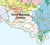
Traditional Owners — This dive site is in the traditional Country of the Boon Wurrung / Bunurong people of the Kulin Nation. This truly ancient Country includes parts of Port Phillip, from the Werribee River in the north-west, down to Wilson's Promontory in the south-east, including the Mornington Peninsula, French Island and Phillip Island, plus Western Port. We wish to acknowledge the Boon Wurrung as Traditional Owners. We pay respect to their Ancestors and their Elders, past, present and emerging. We acknowledge Bunjil the Creator Spirit of this beautiful land, who travels as an eagle, and Waarn, who protects the waterways and travels as a crow, and thank them for continuing to watch over this Country today and beyond.
Kitty Miller Bay Location Map
Latitude: 38° 30.626′ S (38.51043° S / 38° 30′ 37.55″ S)
Longitude: 145° 10.248′ E (145.170808° E / 145° 10′ 14.91″ E)
Datum: WGS84 |
Google Map
| Get directions
Added: 2019-06-10 10:30:47 GMT, Last updated: 2022-03-14 15:30:09 GMT
Source: Google Earth
Nearest Neighbour: Speke, 597 m, bearing 141°, SE
Phillip Island.
Depth: 2 to 12 m.
[ Top ]
DISCLAIMER: No claim is made by The Scuba Doctor as to the accuracy of the dive site coordinates listed here. Should anyone decide to use these GPS marks to locate and dive on a site, they do so entirely at their own risk. Always verify against other sources.
The marks come from numerous sources including commercial operators, independent dive clubs, reference works, and active divers. Some are known to be accurate, while others may not be. Some GPS marks may even have come from maps using the AGD66 datum, and thus may need be converted to the WGS84 datum. To distinguish between the possible accuracy of the dive site marks, we've tried to give each mark a source of GPS, Google Earth, or unknown.
Copyright © 2005-2022 by The Scuba Doctor Australia, ABN 88 116 755 170. All rights reserved.
tel. +61 3 5985 1700 :: email. diveshop@scubadoctor.com.au :: Web site by it'sTechnical 2022







![Halcyon Infinity 30lb System [SS Small Backplate] Halcyon Infinity 30lb System [SS Small Backplate]](/diveshop/images/halcyon/Halcyon-Evolve-Wing.jpg)


