Navigation
These Surface Dry Suits for Sailing, Jet Skiing and Kayaking from The Scuba Doctor keep you dry and help keep you warm in the colder months.
Speke
![]() Wreck Dive |
Wreck Dive | ![]() Shore access
Shore access
![]()
![]()
![]()
![]()
Three-Masted Steel Ship | Max Depth: 26 m (85 ft)
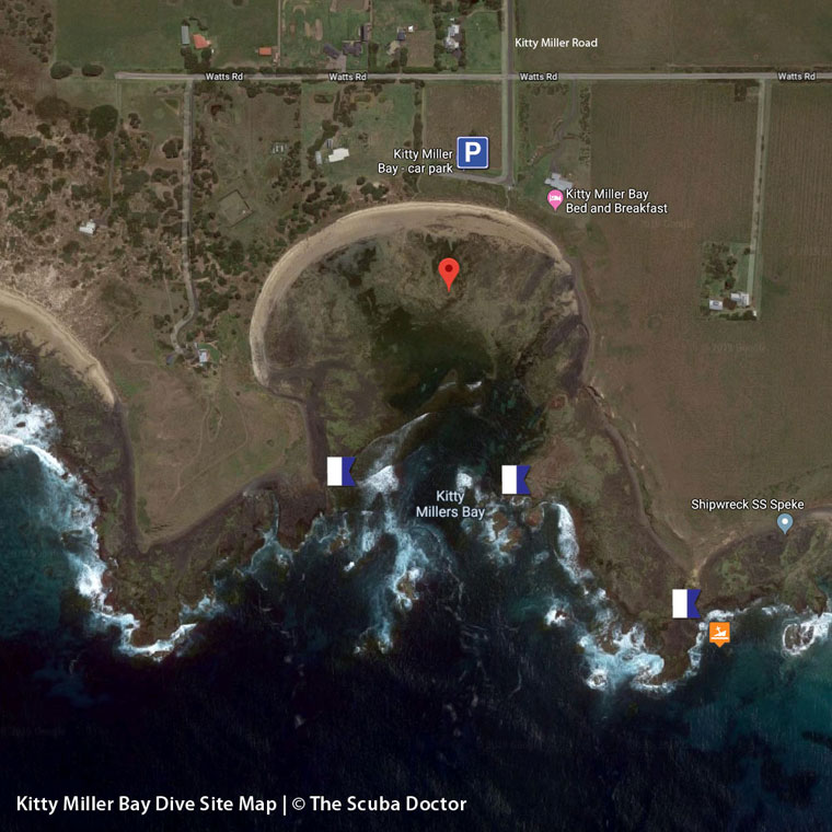
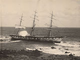
The Speke was the largest British three-masted sailing ship built. The shipwreck lies to the east of Watt Point, around from Kitty Miller Bay, on the south-west coast of Phillip Island, Victoria.
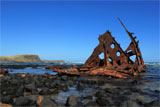
On the drying reef are visible the bow section and stem with timber chock construction and concreted stem, and eroded plating. An anchor cathead with three wooden sheaves lies nearby. The midships and stern of the vessel including the rudderpost are underwater off the beach and have been heavily eroded.
Directions to the Speke Shipwreck
Location: Ventnor, Phillip Island, Victoria 3922
MELWAY Ref: Page 731 E7
Emergency Beach Location: A11
- Travel towards Kitty Miller Bay via Kitty Miller Bay Road.
- Park in the car park, closest to the beach access.
- Walk down the stairs and begin walking left (East) along the beach towards Watt Point.
- Continue for 50 metres hugging the outskirts of the beach, until you see a steep dirt track that leads up the hill.
- Take this track for another 800 metres or so around the cove until you see the wreck on the other side of the cliffs of Watt Point.
- Follow the steep dirt track down on to the beach towards the shipwreck.
Ideal Conditions: The best conditions come after several days of still weather or northerly winds. Best dived at high tide, whenever it is safe to do so. See WillyWeather (Kitty Miller Bay) as a guide for the tide times and the height of the tide.
Bass Strait Warning: Always keep an eye on sea conditions throughout any shore or boat dive in Bass Strait on Victoria's coastline. Please read the warnings on the web page diving-in-bass-strait before diving or snorkelling this site.
Speke Shipwreck History — Built in 1891
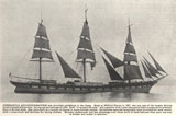
The Speke was a three-masted steel ship rigged vessel of 2,876 gross tons, built in 1891, by T.R. Oswald and Co in Milford Haven, Wales, UK. She was built on the dimensions of 310 ft (94 m) in length, a breadth of 42.2 ft (13 m) and a depth of 25.6 ft (7.8 m).
The Speke was the second-largest ship-rigged vessel ever built. It had square sails on all three masts.
Speke Sinking — Wrecked 22 February 1906
On its final voyage the Speke left Peru bound for Sydney in balast, with a crew of 25, under the command of Captain William Tilston. The voyage across the Pacific took 103 days, and after a minimal stopover in Sydney to pick up orders, it left for Melbourne to load a cargo of wheat for the United Kingdom and Europe.
As the Speke neared Port Phillip no pilot could be obtained. Whilst off Port Phillip Heads the wind freshened from the west and the vessel became unmanageable. The Speke ran ashore on Thursday 22 February 1906 on Phillip Island, not far from Kitty Miller Bay. The Captain's report of events was published in the Argus of 24 February 1906:
At this time the vessel was drifting towards the shore. I set forsail and jib to 'wear ship' but found she would not wear, so I brought her to the wind again. The lead was going constantly. Seeing how things were going against the vessel, I tried to anchor in a sandy bottom, and sought to get her to a patch of beach between the rocks that were all around. The port anchor was let go, and when it had taken out 15 fathoms the starboard anchor was let go. Five minutes later the port cable parted, and we found that the starboard anchor would not hold.
I ordered the boats to be put out, and this was done immediately. By this time we had been carried to within about 50 yards of the rocks. When the starboard lifeboat was lowered with four men in it I ordered the boat to be passed round, but somehow the men in the boat let go the painter. The result was that the boat was capsized immediately. One of the men, Henderson, an A.B., was drowned. The others somehow got to safety. One of them was imprisoned underneath the overturned boat, and was there when the boat was cast upon the rocks. He then kicked away at the boards from the inside till he made a hole for himself to get out by. The ship now struck the rocks stern foremost, and began began to bump very heavily. Most of the crew sought shelter in the wheel house and the lazarette, fearing that each second the masts and rigging would come down.
The situation looked grim for those on board the stricken vessel, however the Captain asked the second mate, Alexander Cook to swim ashore with a line, which he readily agreed to do. After a struggle in the huge Breakers, the second mate gained the shore and was able to secure a line to an outcrop of rock. The Captain lead the way on the line and all of the remaining crew followed, gaining the shore without any further loss of life.
During the Marine Board of Inquiry, the master stated that a bush fire had obscured the land and that heavy seas from the south-west caused the vessel to go ashore. He was found guilty of poor navigation and lost his master's certificate for 12 months.
See also, Heritage Council Victoria: Speke,
Australian National Shipwreck Database: Speke, and
Kitty Miller Bay and the Speke Wreck in "Shore Dives of Victoria" by Ian Lewis, 3rd edition page 150–151.
Heritage Warning: Any shipwreck or shipwreck relic that is 75 years or older is protected by legislation. Other items of maritime heritage 75 years or older are also protected by legislation. Activities such as digging for bottles, coins or other artefacts that involve the disturbance of archaeological sites may be in breach of the legislation, and penalties may apply. The legislation requires the mandatory reporting to Heritage Victoria as soon as practicable of any archaeological site that is identified. See Maritime heritage. Anyone with information about looting or stolen artefacts should call Heritage Victoria on (03) 7022 6390, or send an email to heritage.victoria@delwp.vic.gov.au.
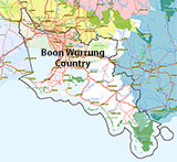
Traditional Owners — This dive site is in the traditional Country of the Boon Wurrung / Bunurong people of the Kulin Nation. This truly ancient Country includes parts of Port Phillip, from the Werribee River in the north-west, down to Wilson's Promontory in the south-east, including the Mornington Peninsula, French Island and Phillip Island, plus Western Port. We wish to acknowledge the Boon Wurrung as Traditional Owners. We pay respect to their Ancestors and their Elders, past, present and emerging. We acknowledge Bunjil the Creator Spirit of this beautiful land, who travels as an eagle, and Waarn, who protects the waterways and travels as a crow, and thank them for continuing to watch over this Country today and beyond.
Speke Location Map
Latitude: 38° 30.879′ S (38.514643° S / 38° 30′ 52.71″ S)
Longitude: 145° 10.504′ E (145.175064° E / 145° 10′ 30.23″ E)
Datum: WGS84 |
Google Map
| Get directions
Added: 2019-05-04 15:46:57 GMT, Last updated: 2022-05-16 06:20:09 GMT
Source: Google Earth
Nearest Neighbour: Kitty Miller Bay, 597 m, bearing 321°, NW
Three-Masted Steel Ship.
Built: Milford Haven, Wales, 1891.
Sunk: 22 February 1906.
Phillip Island.
Depth: 0 to 26 m.
[ Top ]
DISCLAIMER: No claim is made by The Scuba Doctor as to the accuracy of the dive site coordinates listed here. Should anyone decide to use these GPS marks to locate and dive on a site, they do so entirely at their own risk. Always verify against other sources.
The marks come from numerous sources including commercial operators, independent dive clubs, reference works, and active divers. Some are known to be accurate, while others may not be. Some GPS marks may even have come from maps using the AGD66 datum, and thus may need be converted to the WGS84 datum. To distinguish between the possible accuracy of the dive site marks, we've tried to give each mark a source of GPS, Google Earth, or unknown.
Copyright © 2005-2022 by The Scuba Doctor Australia, ABN 88 116 755 170. All rights reserved.
tel. +61 3 5985 1700 :: email. diveshop@scubadoctor.com.au :: Web site by it'sTechnical 2022





![Halcyon Infinity 30lb System [SS Small Backplate] Halcyon Infinity 30lb System [SS Small Backplate]](/diveshop/images/halcyon/Halcyon-Evolve-Wing.jpg)


