Navigation
Looking for Scuba Diving, Snorkelling, Freediving or Spearfishing mask, snorkel and fins for the family or yourself? Whether you're a beginner or have dived or snorkelled in some of the most remote and beautiful parts of the world, you will find the gear you are looking for st The Scuba Doctor.
Note: For child and junior sized mask, snorkel and fin sets, please look at our Kids Corner.
Middle Island
![]() Reef Dive |
Reef Dive | ![]() Shore access
Shore access
![]()
![]()
![]()
![]()
![]()
Depth: 3 m (9.84 ft) to 15 m (49 ft)
Level: Open Water and beyond.
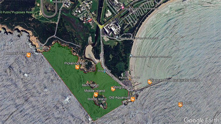
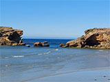
Middle Island (aka Penguin Island) is the larger island in the mouth of Stingray Bay with great shore diving and snorkelling. It features boulders, channels, overhangs, and swim throughs. Middle Island lies in the Merri Marine Sanctuary south-west of Warrnambool, located between the Harbour Breakwater and Thunder Point Coastal Reserve, on Victoria's Shipwreck Coast.
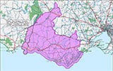
Merri Marine Sanctuary is a protected no-take zone that includes Stingray Bay. See the Merri Marine Sanctuary Map.
Diving and Snorkelling at Middle and Merri Islands
The are essentially two types of dives at this location. You can stay on the protected shore side of Middle and Merri Islands, in Stingray Bay, and explore the intertidal zone along the shore of the islands.
If conditions permit, you can also explore the outer Southern Ocean side of Middle and Merri Islands. It needs to be very calm with low swell for this to be possible. Conditions need to be constantly monitored as they can change quickly into dangerously rough seas with big sells and strong currents.
In close to Middle Island, and Merri Island to the north-west, are kelp forests and plenty of marine life. Overhangs and crevices provide excellent hiding spots for marine animals. There are some holes to 15 metres deep but mostly the area is 8 metres to 10 metres deep.
Between Middle Island and Merri Island is a deep canyon packed with sea life because of the varying sandy and rocky habitats and cool, nutrient-rich, oxygen charged waters. Beware of surge and strong currents.
The channel between Merri Island and Pickering Point shelves down to deep water reaching 25 metres about 200 metres offshore.
Marine life in the Middle and Merri Island area includes Longsnout Boarfish, Port Jackson Shark, Gulf Wobbegong Shark, lots of Stingrays, Giant Australian Cuttlefish, Draughtboard Shark, Parrotfish, Zebrafish, Southern Rock Lobster (aka Crayfish) and Abalone. From August to February, Middle Island is home to a breeding colony of Little (Fairy) Penguins and Short-tailed Shearwaters.
Note: In a world first, Maremma dogs were trained and placed on Middle Island to protect the penguins from foxes during the breeding season. The story of this was made world famous in the family movie Oddball.
ODDBALL Official Trailer (2015)
Location: Viaduct Road, Warrnambool, Victoria 3280
Parking: Park along the western side of Viaduct Road, near the first set of steps closest to the concrete wall (i.e southern end of the parking). Before gearing up check out the water. If you see lots of white water, head on home.
Entry/Exit: Shore entry is from Singray Bay. Take the steps down onto the beach and enter the water. Swim out towards the channel between Middle and Merri Islands.
Ideal Conditions: This dive site is prone to surge and swell and is best dived at low tide on a low swell with light offshore northerly winds. See WillyWeather (Middle Island) as a guide for the tide times and the height of the tide.
The reefs on the Southern Ocean side of Middle and Merri Islands are often reached by boat from the nearby Warrnambool (Lady Bay) boat ramp.
{{southern-ocean-warning}} {{sally-watson}} {{merri-marine-sanctuary}}Traditional Owners — This dive site is in the traditional Country of the Eastern Maar people of south-western Victoria between the Shaw and Eumerella Rivers and from Yambuk in the south to beyond Lake Linlithgow in the north. This truly ancient Country extends as far north as Ararat and encompasses the coastal townships of Port Fairy in the west, Warrnambool, Peterborough, Port Campbell, Apollo Bay, Lorne, and Airies Inlet in the east, including the Great Ocean Road area. It also stretches 100 metres out to sea from low tide and therefore includes the iconic Twelve Apostles. "Eastern Maar" is a name adopted by the people who identify as Maar, Eastern Gunditjmara, Tjap Wurrung, Peek Whurrong, Kirrae Whurrung, Kuurn Kopan Noot and/or Yarro waetch (Tooram Tribe) amongst others. We wish to acknowledge the Eastern Maar as Traditional Owners. We pay respect to their Ancestors and their Elders, past, present and emerging.
Middle Island Location Map
Latitude: 38° 24.197′ S (38.40328° S / 38° 24′ 11.81″ S)
Longitude: 142° 28.283′ E (142.471376° E / 142° 28′ 16.95″ E)
Datum: WGS84 |
Google Map
| Get directions
Added: 2021-06-08 17:44:04 GMT, Last updated: 2022-05-24 08:51:33 GMT
Source: Google Earth
Nearest Neighbour: Stingray Bay, 189 m, bearing 71°, ENE
Merri Marine Sanctuary.
Warrnambool, Shipwreck Coast.
Depth: 3 to 15 m.
[ Top ]
DISCLAIMER: No claim is made by The Scuba Doctor as to the accuracy of the dive site coordinates listed here. Should anyone decide to use these GPS marks to locate and dive on a site, they do so entirely at their own risk. Always verify against other sources.
The marks come from numerous sources including commercial operators, independent dive clubs, reference works, and active divers. Some are known to be accurate, while others may not be. Some GPS marks may even have come from maps using the AGD66 datum, and thus may need be converted to the WGS84 datum. To distinguish between the possible accuracy of the dive site marks, we've tried to give each mark a source of GPS, Google Earth, or unknown.
Copyright © 2005-2022 by The Scuba Doctor Australia, ABN 88 116 755 170. All rights reserved.
tel. +61 3 5985 1700 :: email. diveshop@scubadoctor.com.au :: Web site by it'sTechnical 2022









![Halcyon Infinity 30lb System [SS Small Backplate] Halcyon Infinity 30lb System [SS Small Backplate]](/diveshop/images/halcyon/Halcyon-Evolve-Wing.jpg)


