Navigation
The Scuba Doctor has dive accessories to make your diving more enjoyable, plus help you to clean and care for your scuba equipment.
There has yet to be a diver who submerges without some kind of accessory to make the dive go just a little easier. It could be a stainless steel clip to hold a light, a jon-line to make the decompression just a little bit more comfortable. At The Scuba Doctor we have consulted with divers from around the world, tapped into our own service technicians, and scoured the globe for the best manufacturers to bring you the most comprehensive and complete collection of accessories of any company in Australia. If there is something you need that is not on the site drop us an e-mail or give us a call and we will be happy to source it for you.
Tech Tip:
Take Only What You Need, No More and No Less
New divers have a tendency to use equipment to replace skills, which is a reasonable approach to maximise enjoyment of the early dives. However, we have seen divers looking like they walked through a dive shop with a magnet and we wonder who recommended all that stuff.
Experienced divers know that every tool, gadget or feature they add to their configuration increases the complexity and also increases failure points. As the diver develops improved skills, they begin to shed gear and elaborate features in favor of streamlined high-quality equipment configurations. The huge knife strapped to the leg disappears along with the snorkel, instrument console and retractor, most of the lead, tank banger, eventually the jacket style BC and even the split fins.
When gearing up, the experienced diver will take only the tools really needed for the specific dive. They know that simple and quality equipment together with practiced skills are the most elegant and reliable configurations.
Portarlington Pier
![]() Pier Dive |
Pier Dive | ![]() Shore access
Shore access
![]()
![]()
![]()
![]()
![]()
![]()
Depth: 2 m (6.56 ft) to 5 m (16 ft)
Level: Open Water and beyond.
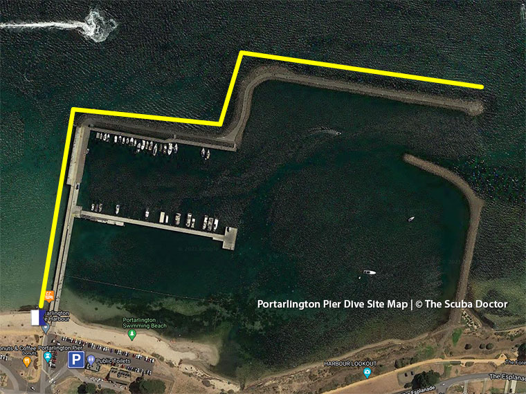
Portarlington Pier on the Bellarine Peninsula is best dived at high tide for extra depth under the pier. The sheltered, sandy site makes a nice night dive. You'll probably spend most of your time exploring the outer wall, but beware of fishing lines and take a good dive knife.
Don't forget to check out the artificial reefs 40 to 70 metres seaward of Portarlington Pier's rock wall section. As they are more than 30 metres away from the pier, you can go spearfishing on them.
Location: Portarlington
MELWAY Ref: Page 444 H6
Protected from southerly winds. See WillyWeather (Portarlington Pier) as a guide for the tide times and the height of the tide.
Victorian Fisheries Authority (VFA) Shore Based Reefs in Port Phillip
The artificial Port Phillip Shore Reefs were installed with the aim of improving recreational fishing opportunities for shore based anglers. The reefs are in a water depth of between 3 to 4.5 metres.
The shore based artificial reefs are:
- Altona Pier — Artificial reef 40 to 65 metres seaward from the end of Altona Pier.
- Frankston Pier — Articial reef approximately 40 metres seaward from the end of Frankston Pier.
- Portarlington Pier — Artificial reef 40 to 70 metres seaward of Portarlington Pier's rock wall section.
What Do The Reefs Look Like?
Each reef consists of 99 hollow dome shaped reef modules of different sizes arranged in three reef complexes of 33 reef modules each. The reef modules range between 170 and 340 kg in weight and 50 to 60 cm height, and have numerous external openings to allow movement of currents and fish through the modules.
See also, VFA: Shore Based Reefs.
Spearfishing is illegal within 30 metres of any pier or jetty and in Marine National Parks. See Spearfishing Laws.
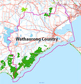
Traditional Owners — This dive site is in the traditional Country of the Wathaurong (Wadda-Warrung) people of the Kulin Nation. This truly ancient Country includes the coastline of Port Phillip, from the Werribee River in the north-east, the Bellarine Peninsula, and down to Cape Otway in the south-west. We wish to acknowledge the Wathaurong as Traditional Owners. We pay respect to their Ancestors and their Elders, past, present and emerging. We acknowledge Bunjil the Creator Spirit of this beautiful land, who travels as an eagle, and Waarn, who protects the waterways and travels as a crow, and thank them for continuing to watch over this Country today and beyond.
Portarlington Pier Location Map
Latitude: 38° 6.752′ S (38.112541° S / 38° 6′ 45.15″ S)
Longitude: 144° 39.109′ E (144.651819° E / 144° 39′ 6.55″ E)
Datum: WGS84 |
Google Map
| Get directions
Added: 2012-07-22 09:00:00 GMT, Last updated: 2022-03-22 14:08:30 GMT
Source: GPS
Nearest Neighbour: Steeles Rocks, Portarlington, 1,175 m, bearing 87°, E
Bellarine Peninsula.
Depth: 2 to 5 m.
[ Top ]
DISCLAIMER: No claim is made by The Scuba Doctor as to the accuracy of the dive site coordinates listed here. Should anyone decide to use these GPS marks to locate and dive on a site, they do so entirely at their own risk. Always verify against other sources.
The marks come from numerous sources including commercial operators, independent dive clubs, reference works, and active divers. Some are known to be accurate, while others may not be. Some GPS marks may even have come from maps using the AGD66 datum, and thus may need be converted to the WGS84 datum. To distinguish between the possible accuracy of the dive site marks, we've tried to give each mark a source of GPS, Google Earth, or unknown.
Copyright © 2005-2022 by The Scuba Doctor Australia, ABN 88 116 755 170. All rights reserved.
tel. +61 3 5985 1700 :: email. diveshop@scubadoctor.com.au :: Web site by it'sTechnical 2022


![Halcyon Infinity 30lb System [SS Small Backplate] Halcyon Infinity 30lb System [SS Small Backplate]](/diveshop/images/halcyon/Halcyon-Evolve-Wing.jpg)


