Navigation
San Remo Bridge
![]() Drift Dive |
Drift Dive | ![]() Shore access
Shore access
![]()
![]()
![]()
![]()
Depth: 3 m (9.84 ft) to 13 m (43 ft)
Level: Advanced Open Water and beyond
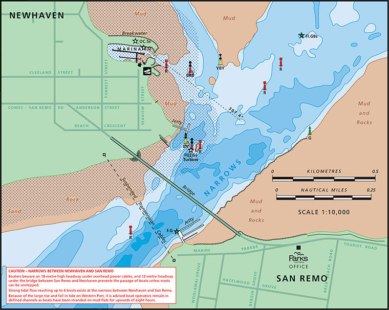
San Remo Bridge is the gateway to Phillip Island. The bridge spans the gap between the mainland at San Remo, and Newhaven on Phillip Island, which is known as The Narrows.
Warning: Do not even think about diving this site unless you are an extremely fit diver who is highly competent diving in very fast currents.
Currents are a huge factor when trying to do a drift dive at San Remo Bridge. Extremely strong tidal currents swirl through The Narrows sometimes as fast as 6 knots. Thus this drift dive requires a huge degree of skill, careful observation, and cautious timing. It should not be attempted unless you have done many dives under San Remo Jetty and are thus aware of how fast the local currents run, how quickly they change, and where best to enter and exit the water.
The purpose of this drift dive is to leave the shore at the San Remo Jetty near the end of a flood tide, head out to the rocky reef mid-channel under the bridge, and then quickly head back to the San Remo Pier and beach as soon as you get an indication of the ebb tide current change. Thus you might get 10 minutes to explore the reef mid-channel during slack water.
The reef is covered in corals and supports lots of marine life. Everything gets a rich feast from the nutrients delivered on the strong currents in The Narrows.
To successfully drift dive the San Remo Bridge you need to take your time and carefully observe the current flow. Be ready to enter the water from the beach just as the flood current is about to end. Head out to the bridge pylons mid-channel. If you get the timing of your return right, you should be able to safely return to the San Remo Jetty and beach. If not, you'll be in big trouble, drifting at up to 6 knots past Cape Woolamai and on your way to Tasmania.
See WillyWeather (Newhaven) as a guide for the tide times and the height of the tide.
Do not underestimate the fitness, skills and experience required to do this drift dive.
See also, San Remo Bridge Pylon Drift in "Shore Dives of Victoria" by Ian Lewis, 3rd edition page 140.
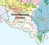
Traditional Owners — This dive site is in the traditional Country of the Boon Wurrung / Bunurong people of the Kulin Nation. This truly ancient Country includes parts of Port Phillip, from the Werribee River in the north-west, down to Wilson's Promontory in the south-east, including the Mornington Peninsula, French Island and Phillip Island, plus Western Port. We wish to acknowledge the Boon Wurrung as Traditional Owners. We pay respect to their Ancestors and their Elders, past, present and emerging. We acknowledge Bunjil the Creator Spirit of this beautiful land, who travels as an eagle, and Waarn, who protects the waterways and travels as a crow, and thank them for continuing to watch over this Country today and beyond.
San Remo Bridge Location Map
Latitude: 38° 31.116′ S (38.518605° S / 38° 31′ 6.98″ S)
Longitude: 145° 21.866′ E (145.364429° E / 145° 21′ 51.94″ E)
Datum: WGS84 |
Google Map
| Get directions
Added: 2019-05-05 10:36:27 GMT, Last updated: 2022-03-22 16:16:17 GMT
Source: Google Earth
Nearest Neighbour: San Remo Jetty, 220 m, bearing 172°, S
San Remo, Phillip Island.
Depth: 3 to 13 m.
[ Top ]
DISCLAIMER: No claim is made by The Scuba Doctor as to the accuracy of the dive site coordinates listed here. Should anyone decide to use these GPS marks to locate and dive on a site, they do so entirely at their own risk. Always verify against other sources.
The marks come from numerous sources including commercial operators, independent dive clubs, reference works, and active divers. Some are known to be accurate, while others may not be. Some GPS marks may even have come from maps using the AGD66 datum, and thus may need be converted to the WGS84 datum. To distinguish between the possible accuracy of the dive site marks, we've tried to give each mark a source of GPS, Google Earth, or unknown.
Copyright © 2005-2022 by The Scuba Doctor Australia, ABN 88 116 755 170. All rights reserved.
tel. +61 3 5985 1700 :: email. diveshop@scubadoctor.com.au :: Web site by it'sTechnical 2022








![Halcyon Infinity 30lb System [SS Small Backplate] Halcyon Infinity 30lb System [SS Small Backplate]](/diveshop/images/halcyon/Halcyon-Evolve-Wing.jpg)


