Henrietta
![]() Wreck Dive |
Wreck Dive | ![]() Shore access
Shore access
![]()
![]()
![]()
![]()
Two-Masted Wooden Schooner | Max Depth: 8 m (26 ft)
The Henrietta shipwreck's location was lost until 1967 when it was relocated by an abalone diver. The vessel's rudder was removed, an anchor and other portions of the vessel were removed once it was discovered. The location of many of these artifacts has now been lost.
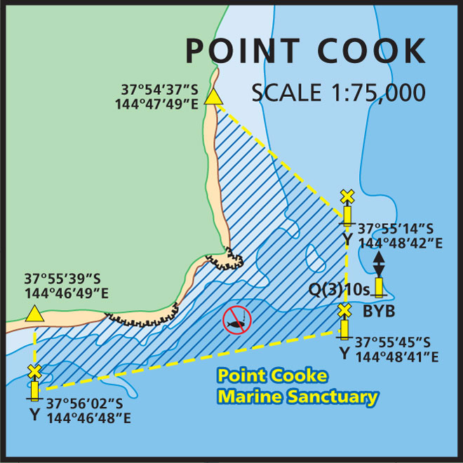
Today, there isn't much left of the Henrietta, the weather and shallow water have taken their toll. There is a large 8 metre by 5-metre mound of pig iron ballast, rising 1.5 metres off the seabed in 3 metres of water about 150 metres east of shallow basalt reef, 400 metres offshore at Point Cook. Four star pickets mark the site. All timber relating to the vessel is gone. Some small fittings identified. The ship's nameboard, adorns the entrance to a museum in Altona.
Henrietta Shipwreck History — Built in 1915
The Henrietta had a colourful career. Built in 1915, by Arthur Dana Story in Gloucester, Massachusetts, USA, the Henrietta was an elegant two-masted schooner built for the cod fishing industry. There are also rumours the boat was used in the film Captain Courageous starring Spencer Tracey, but this has never been confirmed. She measured 114 ft (35 m) long, 22.1 ft (6.74 m) wide and 10.9 ft (3.32 m) deep.
After a fishing career lasting 20 years, Henrietta was bought by American Bailey (Peter) Sawyer and his Australian-born wife Dorota and they left America for Sydney. After arriving in Australia, they quickly became involved in scientific and research trips. The Royal Australian Navy was concerned that the Japanese pearl luggers operating in the Great Barrier Reef area had discovered previously uncharted navigable channels. These could prove a problem if the Japanese invaded during the war so Henrietta was employed to chart as many of these channels as possible. In all, they managed to navigate and chart ten new channels.
At the beginning of 1940, Sawyer enrolled in the RAAF and quickly became a pilot-officer, thanks in no small part to his skill in celestial navigation learnt on the water. Meanwhile, Henrietta lay at anchor in Geelong.
Henrietta Final Voyage and Sinking — 29 September 1940
The Port Phillip Sea Pilots were considering using Henrietta as a pilot vessel and the navigation charts were removed from the vessel to update them for pilot duty. Unfortunately, there weren't returned in time for Henrietta's last voyage.
Henrietta's end was somewhat ignominious for such an elegant yet adventurous vessel. Sawyer and three friends from his RAAF base in Laverton decided to take Henrietta to Williamstown for dry-docking and an overhaul.
Leaving Geelong before dawn on the morning of 28 September 1940, the weather was squally and deteriorating. When the crew went looking for the Port Phillip navigation chart, they discovered it was missing.
Henrietta ran into the reef that extends out more than a mile from Point Cook. The weather had hidden the danger mooring buoy from view. The Ports and Harbours tug, Victory, was sent to help drag Henrietta into deep water — unsuccessfully. The crew decided to wait overnight for the flood tide and try again. It was an unpleasant experience. High winds and huge seas swept Henrietta's lifeboats away and their emergency flares weren't seen in the bad weather.
The crew (and the ship's cat) had to wait until 12.30 pm the next day before they could be rescued.
Peter Sawyer was killed in an air crash in the Blue Mountains a few months after the wreck... coincidentally the same weekend an enormous storm finally smashed Henrietta to pieces. Sawyer's ashes were scattered over the site and when Dorota died, her ashes were scattered nearby.
Henrietta, in its short time in Australia became very much a part of Australia's maritime history and now what's left is protected under the Heritage Act 1995.
See also, Australian National Shipwreck Database: Henrietta, and
Heritage Council Victoria: Henrietta.
Heritage Warning: Any shipwreck or shipwreck relic that is 75 years or older is protected by legislation. Other items of maritime heritage 75 years or older are also protected by legislation. Activities such as digging for bottles, coins or other artefacts that involve the disturbance of archaeological sites may be in breach of the legislation, and penalties may apply. The legislation requires the mandatory reporting to Heritage Victoria as soon as practicable of any archaeological site that is identified. See Maritime heritage. Anyone with information about looting or stolen artefacts should call Heritage Victoria on (03) 7022 6390, or send an email to [email protected].
Finding the Henrietta Shipwreck
It's unlikely the GPS mark from the Australian National Shipwreck Database is accurate. If anyone has an accurate mark, please pass it on to us.
Traditional Owners — This dive site is in the traditional Country of the Boon Wurrung / Bunurong people of the Kulin Nation. This truly ancient Country includes parts of Port Phillip, from the Werribee River in the north-west, down to Wilson's Promontory in the south-east, including the Mornington Peninsula, French Island and Phillip Island, plus Western Port. We wish to acknowledge the Boon Wurrung as Traditional Owners. We pay respect to their Ancestors and their Elders, past, present and emerging. We acknowledge Bunjil the Creator Spirit of this beautiful land, who travels as an eagle, and Waarn, who protects the waterways and travels as a crow, and thank them for continuing to watch over this Country today and beyond.
Henrietta Location Map
Latitude: 37° 55.800′ S (37.93° S / 37° 55′ 48″ S)
Longitude: 144° 48.600′ E (144.81° E / 144° 48′ 36″ E)
Datum: WGS84 |
Google Map
| Get directions
Added: 2018-01-27 04:38:46 GMT, Last updated: 2022-05-07 00:27:11 GMT
Source: Australasian Underwater Cultural Heritage Database (approximate location only)
Nearest Neighbour: Point Cooke Homestead, 1,668 m, bearing 279°, W
Two-Masted Wooden Schooner.
Built: Gloucester, Massachusetts, USA, 1915.
Lost: 29 September 1940.
Point Cook, Port Phillip.
Depth: 8 m.
[ Top ]
DISCLAIMER: No claim is made by The Scuba Doctor as to the accuracy of the dive site coordinates listed here. Should anyone decide to use these GPS marks to locate and dive on a site, they do so entirely at their own risk. Always verify against other sources.
The marks come from numerous sources including commercial operators, independent dive clubs, reference works, and active divers. Some are known to be accurate, while others may not be. Some GPS marks may even have come from maps using the AGD66 datum, and thus may need be converted to the WGS84 datum. To distinguish between the possible accuracy of the dive site marks, we've tried to give each mark a source of GPS, Google Earth, or unknown.


