Newfield
![]() Wreck Dive |
Wreck Dive | ![]() Boat access
Boat access
![]()
![]()
![]()
![]()
Three Masted Iron Barque | Max Depth: 7 m (23 ft)
Level: Open Water and beyond.
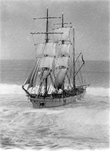
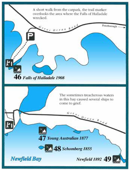
The Newfield shipwreck lies offshore in Newfield Bay about 1 kilometre east of Peterborough on Victoria's Shipwreck Coast. On 29 August 1892, the Newfield ran aground on a series of offshore reefs. There were 26 people on board and nine lives lost.
Diving and Snorkelling the Newfield Shipwreck
The wreck is located in a low relief substrate and is very exposed with dangerous and unpredictable swells breaking. It lies in depths ranging from 5 to 7 metres. Near perfect diving and boating conditions are required to view the wreck.
Newfield Shipwreck History — Built in 1869
The Newfield was a three-masted iron and steel hulled barque of 1,386 tons built in 1869 by Stephen & Sons of Dundee, Scotland. The vessel had a length of 248.6 ft (76 m), a breadth of 35.3 ft (11 m), and a depth of 21.6 ft (6.58 m).
Newfield Sinking — 29 August 1892
The Newfield departed Sharpness, Scotland on 28 May 1892 bound for Brisbane with a crew of 25 under the command of Captain George Scott. Exceptionally rough weather had been encountered and hurricanes and storms after the Cape of Good Hope.
On the night of 28 August 1892, the Captain mistook the Cape Otway light for that of Cape Wickham (King Island) and altered tack to the north and east putting the vessel on a collision course with the Victorian coast. At around 3:40 am the Newfield struck rocks about 100 yards from shore, and 5 feet of water filled the holds immediately. The captain gave orders to lower the boats which caused a disorganised scramble for safety among the crew.
The starboard lifeboat was cleared for lowering with two seamen and two apprentices in her, but almost as soon as she touched the water she was smashed to bits against the side of the vessel, and only one of the four reached safety ashore, the able seaman McLeod.
The whole of those remaining on the Newfield then sought to reach shore with the port lifeboat, but this time the boat was swamped, and only 10 of the crew clambered back aboard the Newfield again, convinced now that the ship was their safest place.
After daybreak at 7:30 am the second mate, Mr. Bradley, and seven seamen cleared away the jolly boat and made it to shore. The second mate and three hands then tried to return to the Newfield to rescue the rest of the crew but the craft was overturned in the surf. The four men made it back to shore.
At midday the rocket rescue team from Port Campbell failed to secure a rocket apparatus line to the ship. The first mate, Mr. R. Simpson, and the remaining crew launched the captain's gig and made it to the shore. Of a total crew of 26, nine crew including the captain lost their lives trying to make the shore.
The Marine Board inquiry found the wreck was caused by a 'one-man style of navigation' and that the Captain had not heeded the advice of his crew.
See also, west-coast-shipwreck-trail, and
Heritage Council Victoria: Newfield.
Heritage Warning: Any shipwreck or shipwreck relic that is 75 years or older is protected by legislation. Other items of maritime heritage 75 years or older are also protected by legislation. Activities such as digging for bottles, coins or other artefacts that involve the disturbance of archaeological sites may be in breach of the legislation, and penalties may apply. The legislation requires the mandatory reporting to Heritage Victoria as soon as practicable of any archaeological site that is identified. See Maritime heritage. Anyone with information about looting or stolen artefacts should call Heritage Victoria on (03) 7022 6390, or send an email to [email protected].
Finding the Newfield Shipwreck
Over the years we've been provided with different GPS marks for the Newfield. The GPS marks we know of in circulation for the Newfield are:
- GPS (verified):
Latitude: 38° 37.066′ S (38.617765591335° S / 38° 37′ 3.96″ S)
Longitude: 142° 54.367′ E (142.90612108084° E / 142° 54′ 22.04″ E) - Dive Victoria:
Latitude: 38° 37.500′ S (38.625° S / 38° 37′ 30″ S)
Longitude: 142° 54.750′ E (142.9125° E / 142° 54′ 45″ E)
977 m, bearing 145°, SE
Traditional Owners — This dive site is in the traditional Country of the Eastern Maar people of south-western Victoria between the Shaw and Eumerella Rivers and from Yambuk in the south to beyond Lake Linlithgow in the north. This truly ancient Country extends as far north as Ararat and encompasses the coastal townships of Port Fairy in the west, Warrnambool, Peterborough, Port Campbell, Apollo Bay, Lorne, and Airies Inlet in the east, including the Great Ocean Road area. It also stretches 100 metres out to sea from low tide and therefore includes the iconic Twelve Apostles. "Eastern Maar" is a name adopted by the people who identify as Maar, Eastern Gunditjmara, Tjap Wurrung, Peek Whurrong, Kirrae Whurrung, Kuurn Kopan Noot and/or Yarro waetch (Tooram Tribe) amongst others. We wish to acknowledge the Eastern Maar as Traditional Owners. We pay respect to their Ancestors and their Elders, past, present and emerging.
Newfield Location Map
Latitude: 38° 37.066′ S (38.617766° S / 38° 37′ 3.96″ S)
Longitude: 142° 54.367′ E (142.906121° E / 142° 54′ 22.04″ E)
Datum: WGS84 |
Google Map
Added: 2012-07-22 09:00:00 GMT, Last updated: 2022-05-18 11:05:43 GMT
Source: GPS (verified)
Nearest Neighbour: Schomberg, 1,149 m, bearing 272°, W
Three-Masted Iron Sailing Barque.
Built: Dundee, Scotland, 1889.
Sunk: 29 August 1892.
Shipwreck Coast.
Depth: 7 m.
[ Top ]
DISCLAIMER: No claim is made by The Scuba Doctor as to the accuracy of the dive site coordinates listed here. Should anyone decide to use these GPS marks to locate and dive on a site, they do so entirely at their own risk. Always verify against other sources.
The marks come from numerous sources including commercial operators, independent dive clubs, reference works, and active divers. Some are known to be accurate, while others may not be. Some GPS marks may even have come from maps using the AGD66 datum, and thus may need be converted to the WGS84 datum. To distinguish between the possible accuracy of the dive site marks, we've tried to give each mark a source of GPS, Google Earth, or unknown.


