Queensland
![]() Wreck Dive |
Wreck Dive | ![]() Boat access
Boat access
![]()
![]()
![]()
![]()
Three-Masted, Single Screw Schooner | Max Depth: 65 m (213 ft)
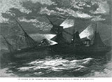
The shipwreck of the Queensland (aka SS Queensland) lies about 35 km due east of Wilsons Promontory, Victoria in about 65 metres of water. The SS Queensland was an Iron single screw passenger and cargo vessel owned by the Eastern and Australian Mail Steam Company. The ship sank off the coast of Wilsons Promontory on the 3rd August 1876 after a collision with the SS Barrabool.
Diving the SS Queensland Shipwreck
Located by G Hodge, M Ryan, M Whitmore, P Taylor and J Osmond of Souhern Ocean Exploration (SOE) on 25 June 2005, the SS Queensland lies at a depth of 65 m (213 ft) on a sandy bottom. It is substantially intact with engines, boilers, winches, machinery, anchors, masts and chain on the site and it sits upright on the seabed.
SS Queensland Shipwreck History
The SS Queensland was an Iron, single screw, three-masted, passenger and cargo schooner built in 1875 by Palmers Co Ltd of Jarrow, Newcastle, England, for Eastern and Australian Mail Steam Co Ltd. The ship was of 2,263 gross tons displacement, with a length of 325.3 ft (99 m), a width of 36.7 ft (11 m), and a depth of 25 ft (7.62 m). She had a two-cylinder inverted compounded steam engine of 309 hp. The hull was constructed with six watertight bulkheads and was rigged as a three-masted topsail schooner.
Just prior to its wrecking in 1876, the passenger steamship Queensland was described by The Age as 'one of the finest steamers to visit Melbourne'.
SS Queensland Sinking
The large iron steamer Queensland, captained by the highly esteemed Robert Craig, sank off Wilsons Promontory after colliding with the steamer Barrabool in the early morning of 3 August 1876. The second mate of the Barrabool mistook the masthead light of the Queensland for the Wilsons Promontory lighthouse and made course for it.
The SS Barrabool was running full speed when it struck the Queensland's starboard side. The Queensland was badly damaged on the starboard side and sank in just 35 minutes. One crewman on the Queensland, second steward James Thomson, was reported missing and presumed drowned, while a number of others from both crews were injured.
Although the starboard bow of the SS Barrabool was badly damaged, it stayed afloat, and managed to keep from taking any water thanks to its sturdy bulkhead. The Barrabool was able to transport the survivors of the Queensland to safety under its own power.
The Queensland, which belonged to the Eastern and Australian Mail Company, was en route to Foo Chow Foo via Sydney, after offloading its cargo of Chinese tea at Melbourne's Sandridge Pier.
The second mate of the Barrabool, Ainsworth, had his certificate cancelled after his actions prior to the accident were found by the Steam Navigation Board to be reckless and the cause of the collision.
See also Heritage Council Victoria: SS Queensland,
Southern Ocean Exploration: SS Queensland, and
Australian National Shipwreck Database: SS Queensland.
Heritage Warning: Any shipwreck or shipwreck relic that is 75 years or older is protected by legislation. Other items of maritime heritage 75 years or older are also protected by legislation. Activities such as digging for bottles, coins or other artefacts that involve the disturbance of archaeological sites may be in breach of the legislation, and penalties may apply. The legislation requires the mandatory reporting to Heritage Victoria as soon as practicable of any archaeological site that is identified. See Maritime heritage. Anyone with information about looting or stolen artefacts should call Heritage Victoria on (03) 7022 6390, or send an email to heritage.victoria@delwp.vic.gov.au.
Finding the SS Queensland Shipwreck
It's unlikely the GPS mark from the Australian National Shipwreck Database is accurate. If anyone has an accurate mark, please pass it on to us.
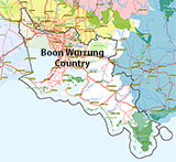
Traditional Owners — This dive site is in the traditional Country of the Boon Wurrung / Bunurong people of the Kulin Nation. This truly ancient Country includes parts of Port Phillip, from the Werribee River in the north-west, down to Wilson's Promontory in the south-east, including the Mornington Peninsula, French Island and Phillip Island, plus Western Port. We wish to acknowledge the Boon Wurrung as Traditional Owners. We pay respect to their Ancestors and their Elders, past, present and emerging. We acknowledge Bunjil the Creator Spirit of this beautiful land, who travels as an eagle, and Waarn, who protects the waterways and travels as a crow, and thank them for continuing to watch over this Country today and beyond.
Bass Strait Warning: Always keep an eye on sea conditions throughout any shore or boat dive in Bass Strait on Victoria's coastline. Please read the warnings on the web page diving-in-bass-strait before diving or snorkelling this site.
Queensland Location Map
Latitude: 39° 6.600′ S (39.11° S / 39° 6′ 36″ S)
Longitude: 146° 43.800′ E (146.73° E / 146° 43′ 48″ E)
Datum: WGS84 |
Google Map
Added: 2019-05-07 21:00:57 GMT, Last updated: 2022-04-25 18:12:16 GMT
Source: Australasian Underwater Cultural Heritage Database (approximate location only)
Nearest Neighbour: Lune, 17,979 m, bearing 351°, N
Three-Masted, Single Screw Schooner.
Built: 1875 in Newcastle, England.
Sunk: 3 August 1876.
Wilsons Promontory, Bass Strait.
Depth: 65 m.
[ Top ]
DISCLAIMER: No claim is made by The Scuba Doctor as to the accuracy of the dive site coordinates listed here. Should anyone decide to use these GPS marks to locate and dive on a site, they do so entirely at their own risk. Always verify against other sources.
The marks come from numerous sources including commercial operators, independent dive clubs, reference works, and active divers. Some are known to be accurate, while others may not be. Some GPS marks may even have come from maps using the AGD66 datum, and thus may need be converted to the WGS84 datum. To distinguish between the possible accuracy of the dive site marks, we've tried to give each mark a source of GPS, Google Earth, or unknown.


