Victoria Tower
![]() Wreck Dive |
Wreck Dive | ![]() Shore access
Shore access
![]()
![]()
![]()
Three-Masted Iron Clipper Ship | Max Depth: 8 m (26 ft)
Level: Open Water and beyond.
The Victoria Tower was a magnificent three-masted, iron-hulled, sailing clipper ship, one of a small class of general cargo traders. The new White Star Clipper, was on her maiden voyage from Liverpool, England, with 34 passengers aboard, when it ran ashore in thick weather on 17 October 1869 at Point Impossible, west of Thompsons Creek, between Breamlea (to the east) and Torquay (to the west) on Victoria's Surf Coast.
In the latter half of the 19th century, iron hulled ships dominated shipping, particularly in Britain and Europe where builders were facing a shortage of timber. However, the use of iron had its problems. Ships' compasses were frequently affected by the ship's inherent magnetic field, in turn affecting navigational accuracy. Victoria Tower had encountered problems with its four compasses during its 85 day voyage to Australia.
Victoria Tower was thought to be have been a magnificent ship. After the vessel was wrecked, the Geelong Advertiser reported;
"One or two of the sails were still flapping uselessly in the breeze and had it not been that the foremast had gone by the board, one could have imagined that the splendid vessel was still pursuing her course. Certainly under full sail, she would have been a beautiful sight. Her lines were greatly admired by those having any knowledge of such subjects".
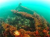
For divers, the legacy of this disaster is the most intact historic shipwreck accessible between Point Lonsdale and Cape Otway. The iron construction has borne up well over the last 130 years, and the dimensions and features of the wreck are easily identifiable.
Diving the Victoria Tower Shipwreck
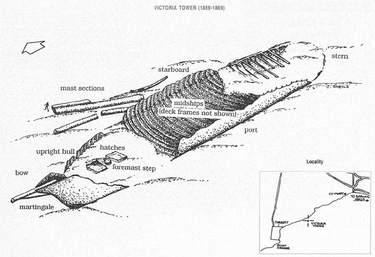
The shipwreck of the Victoria Tower lies in approximately 5 m (16 ft) to 8 m (26 ft) of water on Victoria Reef, a limestone network of underwater caves and gullies typical of the great-southern-reef, off Point Impossible Beach, Torquay. The wreckage extends for approximately 100 m (328 ft) and lies broadside to the shore with its bow facing east.
The most impressive part of the wreck is the bow which is intact. Divers can see a large section of the hull, and the bowsprit and martingale in this region of the wreck site. Good examples of the ship's upright frames can be seen at the starboard midships. Towards the bow and between the deck framing are two hatches, either side of the foremast step.
The masts and yard arm lie on the seaward side of the wreckage.
The site has been extensively salvaged, though divers can sometimes see fragments of ceramics scattered around the wreck and pieces of slate and glass bottles in the hull.
Victoria Reef is subject to heavy surge even in a low swell. When local rivers are in flood, visibility is extremely poor.
Location: Torquay, Victoria 3228
MELWAY Ref: Page 506 K1
Beach Marker: 55W
Parking: Heading south from Melbourne or Geelong along the Surf Coast Highway (B100), turn left before Torquay onto Blackgate Road, then right onto Point Impossible Road. At the southern end of Point Impossible Road turn right and head west along The Esplanade until you come to a track to a car parking area with access to the middle of the Point Impossible Nude Beach at beach marker 55W.
Entry/Exit: Take a look at the conditions. If you see lots of white water, head on home. If conditions are just right, gear up, walk back down onto the beach and enter the water.
Warning: This is a highly hazardous area dominated by strong rips. Always go with a buddy and be extremely careful. Experienced divers and snorkellers only. You need good physical fitness to dive this site in case the conditions change and the swim back to shore becomes hard.
Ideal Conditions: Only attempt to dive or snorkel here if conditions are very calm with little wind, flat seas, and no swell. The beach faces faces south-east, so light offshore westerly to northerly winds can be acceptable. See WillyWeather (Point Impossible Beach) as a guide for the tide times and the height of the tide.
Bass Strait Warning: Always keep an eye on sea conditions throughout any shore or boat dive in Bass Strait on Victoria's coastline. Please read the warnings on the web page diving-in-bass-strait before diving or snorkelling this site.
Victoria Tower Shipwreck History — Built in 1869
The Victoria Tower was a three-masted, iron clipper ship, built in 1869, by Evans in Liverpool, England, with a length of 247 ft (75 m), a beam of 39 ft (12 m), and a draught of 24 ft (7.32 m). The ship's keel was 11 inches (28 cm) thick and above this was an 18 inch (45.7 cm) thick iron framework.
Named after one of the two towers of the British Houses of Parliament, the iron clipper Victoria Tower was an equally magnificent construction. She was in almost all respects a sister ship to the large iron clipper Hoghton Tower. Like the four-masted iron barques George Roper (1883) and Holyhead (1890) wrecked on Lonsdale Reef also while approaching Port Phillip Heads, the Victoria Tower had been built in Liverpool for the Australian trade and was wrecked on its maiden voyage.
She was classed AA1 at Lloyd's, with special mark, and her outfit and finish in every detail were of the highest and most elaborate character.
The Victoria Tower is archaeologically significant as the wreck of an international inward-bound passenger and cargo vessel. It's educationally and recreationally significant as a coherently intact example of a British built iron clipper i.e.: representative of a class or type.
Victoria Tower Sinking — 17 October 1869
Victoria Tower began its maiden and final voyage from Liverpool to Melbourne on 23 July 1869. Its cargo included slate, iron pipes, Guinness Extra Stout and various items of hardware. The ship also carried 34 passengers and a crew of around 25 under the command of Captain John Kerr.
On Saturday 16 October 1869, the Victoria Tower made landfall after a voyage of 85 days from Liverpool and was almost at its destination. That night, the weather was stormy and a thick fog blanketed the coast. Although the compasses had been out, and sightings of land were difficult to make due to the poor weather conditions, Captain Kerr was confident of the ship's position and decided to fire rockets and burned blue lights to attract the attention of the Port Phillip pilot boat.
With no response from the pilot, Captain Kerr ordered the crew to maintain the ship on a starboard tack towards Cape Schanck lighthouse which was only just visible in the distance. Unknown to Captain Kerr, treacherous currents in the area were pulling Victoria Tower off its set course. The Victoria Tower crashed into rocks at 1 a.m. on Sunday 17 October 1869, between Bream Creek and Spring Creek, some 400 yd (366 m) from shore.. The ship hit with such force that the main mast was driven through the keel. Anchors were immediately let go to hold the ship, but it was driven broadside onto the sea, some 400 yards from shore.
Captain Kerr ordered the second mate and four seamen to lower one of the lifeboats and find help ashore. As the small boat was lowered, the main mast snapped in two. The five crew members dived out of the boat to avoid being hit by the falling timber and managed to swim ashore.
The men spent four hours walking through muddy swamps before finding a fence line to follow. Eventually they arrived at the house of Mr Pierce, who with a local fisherman was able to raise the alarm and organise a whale boat to rescue those still on board.
The crew and passengers who remained on Victoria Tower would not have known what was to become of them. They had no idea whether the sailors had made it to shore or if the ship would break-up. Early the next day, all passengers and crew were brought to safety. One of the special passengers, a dog by the name of Ben, (who had become a favourite among the children during the voyage) was greeted with delight after he swam to shore.
There was a great deal of excitement in Geelong as news of the shipwreck spread among the townsfolk. The road to Bream Creek was apparently lined with vehicles of all descriptions and there was "not a horse or any vehicle to be obtained in town".
The Geelong Advertiser remarked at the generosity of the local people towards the shipwreck survivors. "Nearly everybody carried something for the relief of the sufferers; whisky, brandy, tins of preserved meat and loaves of bread". The sailors were also greeted with a tonic of gin, whiskey and rum!
An inquiry held by the Steam Navigation Board on 27 October 1869, found Captain Kerr guilty of negligence and his Captain's certificate was suspended for six months. Victoria Tower was originally valued at £25,000 but the hull and cargo were sold for £6,000. Nearly four years later large quantities of slates and iron pipes were still being recovered as the action of the sea gradually removed obstacles that had previously hindered salvage divers' attempts to reach inaccessible parts of the wreck. In the 1960s some of the slate roofing tiles were used for roofing on the Peninsula Hotel, Moolap. The Anchor was also salvaged.
See also, Heritage Council Victoria: Victoria Tower,
Australian National Shipwreck Database: Victoria Tower, and
Dive Information Sheet: Victoria Tower (1869-1869).
This vessel is one of the many historic shipwrecks included in Victoria's shipwreck-discovery-trail. Qualified divers can explore the wrecks of old wooden clippers, iron steamships and cargo and passenger vessels located along the coast and in Port Phillip. Some of these wreck dives are suitable for beginners, even snorkellers, while other wrecks require the skills and experience of advanced divers.
Heritage Warning: Any shipwreck or shipwreck relic that is 75 years or older is protected by legislation. Other items of maritime heritage 75 years or older are also protected by legislation. Activities such as digging for bottles, coins or other artefacts that involve the disturbance of archaeological sites may be in breach of the legislation, and penalties may apply. The legislation requires the mandatory reporting to Heritage Victoria as soon as practicable of any archaeological site that is identified. See Maritime heritage. Anyone with information about looting or stolen artefacts should call Heritage Victoria on (03) 7022 6390, or send an email to [email protected].
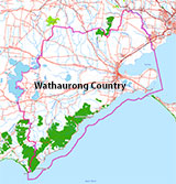
Traditional Owners — This dive site is in the traditional Country of the Wathaurong (Wadda-Warrung) people of the Kulin Nation. This truly ancient Country includes the coastline of Port Phillip, from the Werribee River in the north-east, the Bellarine Peninsula, and down to Cape Otway in the south-west. We wish to acknowledge the Wathaurong as Traditional Owners. We pay respect to their Ancestors and their Elders, past, present and emerging. We acknowledge Bunjil the Creator Spirit of this beautiful land, who travels as an eagle, and Waarn, who protects the waterways and travels as a crow, and thank them for continuing to watch over this Country today and beyond.
Victoria Tower Location Map
Latitude: 38° 18.971′ S (38.316183° S / 38° 18′ 58.26″ S)
Longitude: 144° 22.002′ E (144.3667° E / 144° 22′ 0.12″ E)
Datum: WGS84 |
Google Map
| Get directions
Added: 2012-07-22 09:00:00 GMT, Last updated: 2022-05-10 23:25:58 GMT
Source: GPS
Nearest Neighbour: Point Impossible Reef, 1,472 m, bearing 40°, NE
Three-Masted Iron Clipper Ship, 1,563 ton.
Built: 1869.
Sunk: 17 October 1869.
Point Impossible, Torquay, Surf Coast.
Depth: 8 m.
[ Top ]
DISCLAIMER: No claim is made by The Scuba Doctor as to the accuracy of the dive site coordinates listed here. Should anyone decide to use these GPS marks to locate and dive on a site, they do so entirely at their own risk. Always verify against other sources.
The marks come from numerous sources including commercial operators, independent dive clubs, reference works, and active divers. Some are known to be accurate, while others may not be. Some GPS marks may even have come from maps using the AGD66 datum, and thus may need be converted to the WGS84 datum. To distinguish between the possible accuracy of the dive site marks, we've tried to give each mark a source of GPS, Google Earth, or unknown.


