Wilson Spit Shellfish Reef
![]() Reef Dive |
Reef Dive | ![]() Boat access
Boat access
![]()
![]()
![]()
![]()
Depth: 8 m (26 ft) to 9 m (30 ft)
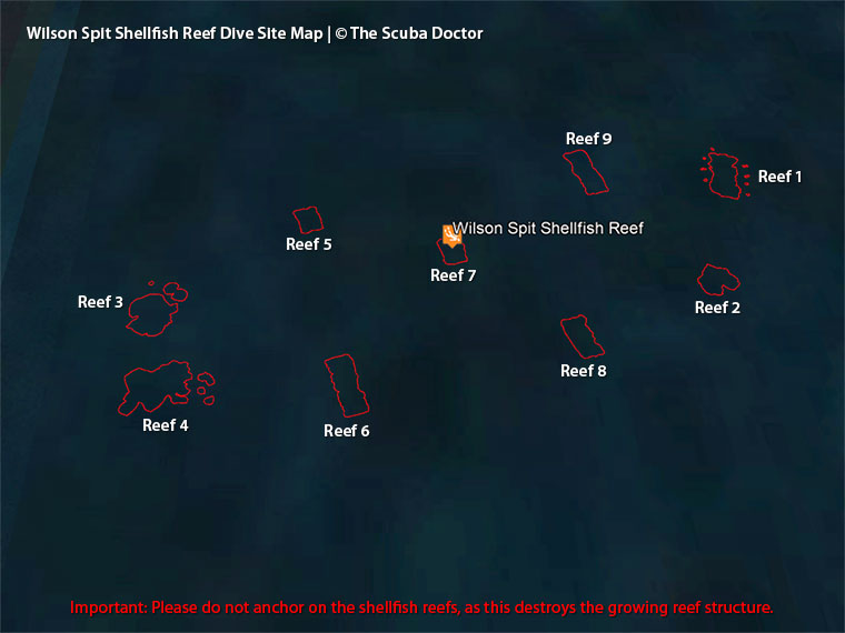
Wilson Spit Shellfish Reef is an artificial, man-made shellfish reef that lies under 10 metres in Corio Bay, situated in the south-western corner of Port Phillip. There are actually four shellfish reefs located as follows:
| Shellfish Reef | Approximate location (WGS84) |
|---|---|
| Wilson Spit Shellfish Reef, Western Port Phillip | |
| Wilson Spit Shellfish Reef 1 621 m2 |
Latitude: 38° 7.132′ S (38.118861° S / 38° 7′ 7.9″ S) Longitude: 144° 30.403′ E (144.506712° E / 144° 30′ 24.16″ E) |
| Wilson Spit Shellfish Reef 2 344 m2 |
Latitude: 38° 7.169′ S (38.119483° S / 38° 7′ 10.14″ S) Longitude: 144° 30.389′ E (144.50648° E / 144° 30′ 23.33″ E) |
| Wilson Spit Shellfish Reef 3 683 m2 |
Latitude: 38° 7.180′ S (38.119672° S / 38° 7′ 10.82″ S) Longitude: 144° 30.218′ E (144.503625° E / 144° 30′ 13.05″ E) |
| Wilson Spit Shellfish Reef 4 890 m2 |
Latitude: 38° 7.200′ S (38.120006° S / 38° 7′ 12.02″ S) Longitude: 144° 30.227′ E (144.50378° E / 144° 30′ 13.61″ E) |
| Wilson Spit Shellfish Reef 5 260 m2 |
Latitude: 38° 7.148′ S (38.119135° S / 38° 7′ 8.89″ S) Longitude: 144° 30.264′ E (144.504398° E / 144° 30′ 15.83″ E) |
| Wilson Spit Shellfish Reef 6 501 m2 |
Latitude: 38° 7.200′ S (38.119997° S / 38° 7′ 11.99″ S) Longitude: 144° 30.276′ E (144.504602° E / 144° 30′ 16.57″ E) |
| Wilson Spit Shellfish Reef 7 (Main) 276 m2 |
Latitude: 38° 7.159′ S (38.11931° S / 38° 7′ 9.52″ S) Longitude: 144° 30.309′ E (144.505156° E / 144° 30′ 18.56″ E) |
| Wilson Spit Shellfish Reef 8 364 m2 |
Latitude: 38° 7.189′ S (38.119809° S / 38° 7′ 11.31″ S) Longitude: 144° 30.346′ E (144.505764° E / 144° 30′ 20.75″ E) |
| Wilson Spit Shellfish Reef 9 532 m2 |
Latitude: 38° 7.131′ S (38.118842° S / 38° 7′ 7.83″ S) Longitude: 144° 30.357′ E (144.505942° E / 144° 30′ 21.39″ E) |
Do Not Anchor: Please do not anchor on the shellfish reefs, as this destroys the growing reef structure.
All recreational fishers and dive boat owners are asked to please do not anchor on or nearby the shellfish reefs, rather drift fish over the reefs.
Do Not Take Shellfish: Please do not take shellfish from the shellfish reefs, as this destroys the growing reef structure. All recreational fishers and divers are asked to please do not take shellfish on or nearby the shellfish reefs. Look, but don't touch.
Victorian Fisheries Authority (VFA) Shellfish Reefs in Port Phillip
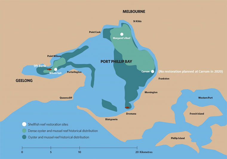
Port Phillip once was home to extensive oyster and mussel reefs that supported a huge range of other sea life including fish, crabs, sea squirts, snails and sponges. Sadly, after many years of over exploitation, pollution, introduced species and disease, these shellfish reefs disappeared. The first series of the Port Phillip shellfish reefs restoration project begun in March 2017 and was completed in November 2018. The project is a partnership between the Victorian Government, The Nature Conservancy, The Thomas Foundation and the Albert Park Yachting and Angling Club, which aim to revitalise shellfish reefs in Port Phillip. Shellfish reefs are one of the world's most threatened marine habitats and once covered up to 50% of Port Phillip's seafloor.
The project has utilised limestone rubble, plus recycled shell from Victoria's restaurant industry, to construct the initial reefs near Geelong and St Kilda, which were selected due to their suitability as they were originally home to shellfish reefs at the time of colonisation.
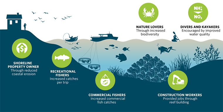
Shellfish reefs provide nursery habitat and overtime will boost fish numbers, clean water and enhance marine biodiversity, which is good news for the environment and recreational fishers. Port Phillip is home to a vibrant snapper, whiting, calamari and flathead fishery, which will all benefit from the reefs.
Each year, one hectare of oyster reef:
- Filters 2.7 billion litres of sea water
- Removes 275 kg of Nitrogen and Phosphate
- Produces 375 kg of fish
- Is home to over 100 marine species
- Recycles 100 m3 of shell
Port Phillip Shellfish Reef Locations
On 22-Mar-2021, The Nature Conservancy provided us with the following detailed information about the location of the shellfish reefs in Port Phillip. Typically each designated reef location is a cluster of one or more separate shellfish reefs. We've picked one reef in each cluster to use as the main location for the reef. This means it's the approximate centre point of an actual shellfish reef, not just an arbitrary location within the area of the cluster of separate reefs. The following table gives you the approximate centre point of each shellfish reef, plus which the one we've picked to be the main location for each cluster.
| Shellfish Reef | Approximate location (WGS84) |
|---|---|
| St Helens Shellfish Reef, Geelong (aka Mervs Reef) |
Latitude: 38° 7.177′ S (38.11961667° S / 38° 7′ 10.62″ S) Longitude: 144° 21.675′ E (144.36125° E / 144° 21′ 40.5″ E) |
| Outer Harbour Shellfish Reef, Corio Bay (aka Moolap Reef) |
Latitude: 38° 6.366′ S (38.1061° S / 38° 6′ 21.96″ S) Longitude: 144° 28.570′ E (144.47616667° E / 144° 28′ 34.2″ E) |
| Kirk Point Shellfish Reef, Western Port Phillip (aka Wilsons Reef) |
Latitude: 38° 3.436′ S (38.05726667° S / 38° 3′ 26.16″ S) Longitude: 144° 36.588′ E (144.6098° E / 144° 36′ 35.28″ E) |
| 9ft Bank Shellfish Reef, Corio Bay | |
| 9ft Bank Shellfish Reef 1 (Main) 16,080 m2 |
Latitude: 38° 6.012′ S (38.1002° S / 38° 6′ 0.72″ S) Longitude: 144° 26.931′ E (144.44885° E / 144° 26′ 55.86″ E) |
| Dromana Shellfish Reef, Eastern Port Phillip | |
| Dromana Shellfish Reef 1 466 m2 |
Latitude: 38° 19.640′ S (38.327331° S / 38° 19′ 38.39″ S) Longitude: 144° 57.002′ E (144.950028° E / 144° 57′ 0.1″ E) |
| Dromana Shellfish Reef 2 274 m2 |
Latitude: 38° 19.665′ S (38.327751° S / 38° 19′ 39.9″ S) Longitude: 144° 57.008′ E (144.950131° E / 144° 57′ 0.47″ E) |
| Dromana Shellfish Reef 3 502 m2 |
Latitude: 38° 19.659′ S (38.327653° S / 38° 19′ 39.55″ S) Longitude: 144° 57.045′ E (144.95075° E / 144° 57′ 2.7″ E) |
| Dromana Shellfish Reef 4 (Main) 494 m2 |
Latitude: 38° 19.637′ S (38.327281° S / 38° 19′ 38.21″ S) Longitude: 144° 57.048′ E (144.950793° E / 144° 57′ 2.85″ E) |
| Dromana Shellfish Reef 5 256 m2 |
Latitude: 38° 19.620′ S (38.326993° S / 38° 19′ 37.17″ S) Longitude: 144° 57.039′ E (144.950645° E / 144° 57′ 2.32″ E) |
| Margaret's Shellfish Reef, Hobsons Bay | |
| Margaret's Shellfish Reef 1 (Main) 1,150 m2 |
Latitude: 37° 53.904′ S (37.898392° S / 37° 53′ 54.21″ S) Longitude: 144° 56.777′ E (144.946286° E / 144° 56′ 46.63″ E) |
| Margaret's Shellfish Reef 2 512 m2 |
Latitude: 37° 53.937′ S (37.898945° S / 37° 53′ 56.2″ S) Longitude: 144° 56.746′ E (144.945763° E / 144° 56′ 44.75″ E) |
| Margaret's Shellfish Reef 3 289 m2 |
Latitude: 37° 53.905′ S (37.898417° S / 37° 53′ 54.3″ S) Longitude: 144° 56.722′ E (144.945364° E / 144° 56′ 43.31″ E) |
| Margaret's Shellfish Reef 4 306 m2 |
Latitude: 37° 53.935′ S (37.898922° S / 37° 53′ 56.12″ S) Longitude: 144° 56.799′ E (144.946647° E / 144° 56′ 47.93″ E) |
| Wilson Spit Shellfish Reef, Western Port Phillip | |
| Wilson Spit Shellfish Reef 1 621 m2 |
Latitude: 38° 7.132′ S (38.118861° S / 38° 7′ 7.9″ S) Longitude: 144° 30.403′ E (144.506712° E / 144° 30′ 24.16″ E) |
| Wilson Spit Shellfish Reef 2 344 m2 |
Latitude: 38° 7.169′ S (38.119483° S / 38° 7′ 10.14″ S) Longitude: 144° 30.389′ E (144.50648° E / 144° 30′ 23.33″ E) |
| Wilson Spit Shellfish Reef 3 683 m2 |
Latitude: 38° 7.180′ S (38.119672° S / 38° 7′ 10.82″ S) Longitude: 144° 30.218′ E (144.503625° E / 144° 30′ 13.05″ E) |
| Wilson Spit Shellfish Reef 4 890 m2 |
Latitude: 38° 7.200′ S (38.120006° S / 38° 7′ 12.02″ S) Longitude: 144° 30.227′ E (144.50378° E / 144° 30′ 13.61″ E) |
| Wilson Spit Shellfish Reef 5 260 m2 |
Latitude: 38° 7.148′ S (38.119135° S / 38° 7′ 8.89″ S) Longitude: 144° 30.264′ E (144.504398° E / 144° 30′ 15.83″ E) |
| Wilson Spit Shellfish Reef 6 501 m2 |
Latitude: 38° 7.200′ S (38.119997° S / 38° 7′ 11.99″ S) Longitude: 144° 30.276′ E (144.504602° E / 144° 30′ 16.57″ E) |
| Wilson Spit Shellfish Reef 7 (Main) 276 m2 |
Latitude: 38° 7.159′ S (38.11931° S / 38° 7′ 9.52″ S) Longitude: 144° 30.309′ E (144.505156° E / 144° 30′ 18.56″ E) |
| Wilson Spit Shellfish Reef 8 364 m2 |
Latitude: 38° 7.189′ S (38.119809° S / 38° 7′ 11.31″ S) Longitude: 144° 30.346′ E (144.505764° E / 144° 30′ 20.75″ E) |
| Wilson Spit Shellfish Reef 9 532 m2 |
Latitude: 38° 7.131′ S (38.118842° S / 38° 7′ 7.83″ S) Longitude: 144° 30.357′ E (144.505942° E / 144° 30′ 21.39″ E) |
Use this KML file to view all of the Port Phillip Shellfish Reef GPS marks supplied by The Nature Conservancy: Port Phillip Shellfish Reef Map. You can use Google Earth to open it and view a layer with polygons of where each restored reef is located. There is also another layer that gives a centre point for each shellfish reef.
Do Not Anchor: Please do not anchor on the shellfish reefs, as this destroys the growing reef structure.
All recreational fishers and dive boat owners are asked to please do not anchor on or nearby the shellfish reefs, rather drift fish over the reefs.
Do Not Take Shellfish: Please do not take shellfish from the shellfish reefs, as this destroys the growing reef structure. All recreational fishers and divers are asked to please do not take shellfish on or nearby the shellfish reefs. Look, but don't touch.

Shellfish reef restoration sites in Port Phillip. Red fish symbol highlights new sites for 2020 reef build. | Source: VRFish
What Do The Shellfish Reefs Look Like?
The project has utilised limestone rubble and recycled shell from Victoria's restaurant industry to construct the shellfish reefs at sites which were selected due to their suitability as they were originally home to shellfish reefs at the time of colonisation.
Restoring the lost shellfish reefs of Port Philip | The Nature Conservancy Australia, 14 Jun 2017
Shellfish Reef Restoration Overview and Progress at Port Phillip, Victoria | The Nature Conservancy Australia, 6 Feb 2019
'Restore The Bay' Information Session - Port Phillip, Victoria | The Nature Conservancy Australia, 27 May 2020
Indigenous Use of Shellfish
Aboriginal kitchen middens were common around Victoria's bays, estuaries and coastal areas. Carbon-dating of shells from middens indicates that the practice of shellfish harvesting by indigenous peoples goes back at least 10,000 years in coastal areas of Victoria. Over 350 coastal shell middens have been recorded for the Bellarine and Mornington Peninsula (Port Phillip) and Phillip Island (Western Port) areas alone. There are middens still observable within the Melbourne metropolitan area of Sandringham and Brighton, but unfortunately many middens sites have been lost to urban and coastal development.
See also, VFA: Shellfish Reefs,
VFA: Shellfish Reefs Revitalisation,
Victoria's lost reefs rediscovered and
Rebuilding Australia's lost shellfish reefs.
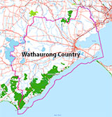
Traditional Owners — This dive site is in the traditional Country of the Wathaurong (Wadda-Warrung) people of the Kulin Nation. This truly ancient Country includes the coastline of Port Phillip, from the Werribee River in the north-east, the Bellarine Peninsula, and down to Cape Otway in the south-west. We wish to acknowledge the Wathaurong as Traditional Owners. We pay respect to their Ancestors and their Elders, past, present and emerging. We acknowledge Bunjil the Creator Spirit of this beautiful land, who travels as an eagle, and Waarn, who protects the waterways and travels as a crow, and thank them for continuing to watch over this Country today and beyond.
Wilson Spit Shellfish Reef Location Map
Latitude: 38° 7.159′ S (38.11931° S / 38° 7′ 9.52″ S)
Longitude: 144° 30.309′ E (144.505156° E / 144° 30′ 18.56″ E)
Datum: WGS84 |
Google Map
Added: 2021-03-14 14:35:45 GMT, Last updated: 2021-05-15 09:37:48 GMT
Source: The Nature Conservancy
Nearest Neighbour: Moolap Reef, 2,910 m, bearing 299°, WNW
Artificial shellfish reef installed to improve recreational fishing.
Depth: 8 to 9 m.
[ Top ]
DISCLAIMER: No claim is made by The Scuba Doctor as to the accuracy of the dive site coordinates listed here. Should anyone decide to use these GPS marks to locate and dive on a site, they do so entirely at their own risk. Always verify against other sources.
The marks come from numerous sources including commercial operators, independent dive clubs, reference works, and active divers. Some are known to be accurate, while others may not be. Some GPS marks may even have come from maps using the AGD66 datum, and thus may need be converted to the WGS84 datum. To distinguish between the possible accuracy of the dive site marks, we've tried to give each mark a source of GPS, Google Earth, or unknown.


